

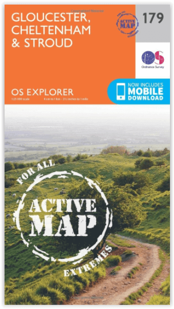
Wandelkaart 179 Gloucester- Cheltenham & Stroud - OSI
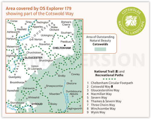
Cotswolds AONB- Vale van Gloucester & de Cotswolds way

Korte omschrijving
Wandelkaarten Gloucestershire, Egland van Ordnance Survey. Ideaal voor tochten in England.
Wandelkaart Gloucester- Cheltenham & Stroud - S.W. England Productbeschrijving: Kaart nummer 179 in de OS Explorer reeks heeft betrekking op de omgeving van Gloucester, Cheltenham, Stroud. H...

Specificaties
- Uitgever: Ordnance Survey
- ISBN-13: 9780319470510
- HOOFDCATEGORIEËN: Wandelkaart
- Activiteiten: Wandelen, Hiking & Trekking
- Regio: Gloucestershire, Egland
- Land: England
- Waterafstotende kaart: Ordnance Survey ACTIVE Explorer Weatherproof Maps
- TOPO's & Stafkaarten: Topografisch wandelen
- AONB - Area of Outstanding Beauty: Cotswolds AONB
- Schaal: 1:25000
- Taal: Engels
- Reeks/Serie: Explorer ACTIVE Series OSI
Volledige omschrijving
Wandelkaart Gloucester- Cheltenham & Stroud - S.W. England
Productbeschrijving: Kaart nummer 179 in de OS Explorer reeks heeft betrekking op de omgeving van Gloucester, Cheltenham, Stroud. Hoogtepunten van het gebied zijn onder andere: Cotswolds AONB gebied van uitzonderlijke natuurlijke schoonheid AONB, Vale van Gloucester, rivier de Severn en de Cotswolds way. De OS Explorer kaart voor Gloucester, Cheltenham & Stroud is beschikbaar in zowel de standaard papieren versie als de weerbestendige 'Actief' versie.
Productdiscription: Map sheet number 179 in the OS Explorer series covers the area around Gloucester, Cheltenham, Stroud. Highlights of the area include: Cotswolds Area of Outstanding Natural Beauty AONB, Vale of Gloucester, River Severn and the Cotswolds Way. The OS Explorer map for Gloucester, Cheltenham & Stroud is available in both the standard paper version and weatherproof 'Active' version.
Locatie op kaart
Gekoppelde artikelen
Wandelkaart 179 Gloucester- Cheltenham & Stroud - OSI • 9780319243725
standaard versieWandelkaart Gloucester- Cheltenham & Stroud - Gloucestershire Productbeschrijving: Gloucester & Cheltenham 179 / Gloucester, Cheltenham & Stroud, Gloucestershire, England - Kaart nummer 179 in de OS Explorer reeks heeft betrekking op de omgeving van Gloucester, Cheltenham, Stroud. Hoogtepunten van het gebied zijn onder meer: The Cotswolds AONB gebied van uitzonderlijke natuurlijke scho…
Wandelkaart 179 Gloucester- Cheltenham & Stroud - OSI • 9780319470510
weatherproof versieWandelkaart Gloucester- Cheltenham & Stroud - S.W. England Productbeschrijving: Kaart nummer 179 in de OS Explorer reeks heeft betrekking op de omgeving van Gloucester, Cheltenham, Stroud. Hoogtepunten van het gebied zijn onder andere: Cotswolds AONB gebied van uitzonderlijke natuurlijke schoonheid AONB, Vale van Gloucester, rivier de Severn en de Cotswolds way. De OS Explorer kaart voor G…
Artikelen uit dezelfde regio

Wandelgids Cotswold Way - Trailblazer Publications • 9781912716418
The Cotswold Way - Trailblazer Publications Productomschrijving: Chipping Campden tot Bath met 49 maps en 30 kleurfoto's. The Cotswolds Way loopt door het befaamd Cotswold AONB (Area of Outstanding Natural Beauty, of regio van uitmunend natuurschoon. The Cotswold Way, is een zeer goed gekende route van een dikke 164 km lang en biedt alles voor de natuurliefhebber. Engelse omschrijving:…

Moutainbike Cotswold Gravel & Mountain AONB - Goldeneye • 9781859653135
Moutainbike map Cotswold - Goldeneye Productomschrijving: Cotswold Gravel & Mountain Bike Routes: The Ultimate Off-Road Experience - Gravel & Mountain Bike Routes 18 (Paperback) When mountainbiking in the Cotswolds, in an Area of Outstanding Natural Beauty of AONB area, a lot of sportsfanatics & MTB fanatics are very interested, and cannot go wrong with this new Goldeneye mountainbiki…

Wandelgids The Offa's Dyke Path - England & Wales - Cicerone • 9781852847760
Wandelgids The Offa's Dyke Path - Wales - Cicerone Productomschrijving: Deze gids beschrijft het Offa's Dyke Path National Trail, een langeafstandswandeling van 283 km langs de Engels-Welshe grens tussen Sedbury (bij Chepstow) en Prestatyn. De gids is opgedeeld in 12 etappes met suggesties voor het plannen van alternatieve routes. Met 1:25K OSI (Ordnance Servey) kaart boekje. Engelse o…

Wandelkaart OL45 - The Cotswolds AONB- Gloucestershire - OSI • 9780319469637
Wandelkaart The Cotswolds AONB - Gloucestershire England Omvat ook: Burford, Chipping Campden, Cirencester & Stow-on-the-Wold Productbeschrijving: Kaart nummer OL45 in de OS Explorer kaarten reeks heeft betrekking op een groot gebied van de Cotswolds AONB, inclusief Stow-on-the-Wold, Burford, Cirencester & Chipping Campden. Hoogtepunten van het gebied: de Cotswold hills, Wychwood comm…

Cotswolds Mountain Biking - Vertebrate Publ. • 9781906148140
Cotswolds AONB Mountain Biking - Vertebrate Productomschrijving: 20 Classic Rides - Cotwolds Mountain Biking by Tom Fenton features 20 classic MTB routes in the Cotswold Hills across the counties of Gloucestershire and Oxfordshire, and extending into parts of Wiltshire, Somerset, Worcestershire and Warwickshire. With Ordnance Survey mapping and easy-to-follow directions. The Cotswold H…