

Wandelkaart 756 Harriman- Bear Mountain & Sterling Forest parks
Harriman State Park is the second largest state park in New York
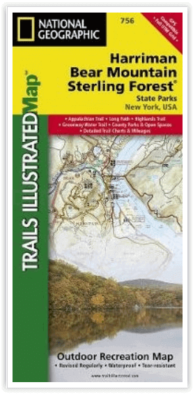
Korte omschrijving
Wandelkaarten New York State, USA van National Geographic. Ideaal voor tochten in Verenigde Staten van Amerika (USA).
Harriman- Bear Mountain & Sterling Forest State Parks - Nat Geo Engelse omschrijving: At over 46,000 acres, Harriman State Park is the second largest state park in New York and is located on...


Specificaties
- Uitgever: National Geographic
- ISBN-13: 9781566956079
- HOOFDCATEGORIEËN: Wandelkaart
- Activiteiten: Wandelen, Hiking & Trekking
- Auteur: National Geographic
- Regio: New York State, USA
- Land: Verenigde Staten van Amerika (USA)
- TOPO's & Stafkaarten: Topografisch wandelen
- Schaal: 1:30000
- Taal: Engels
Volledige omschrijving
Harriman- Bear Mountain & Sterling Forest State Parks - Nat Geo
Engelse omschrijving: At over 46,000 acres, Harriman State Park is the second largest state park in New York and is located only 30 miles north of New York City. It is a haven for hikers with over 200 miles of trails, and water-sport enthusiasts flock to its three beaches and 31 lakes and reservoirs. On the northeastern edge, the park borders the 5,067-acre Bear Mountain State Park which offers a variety of year-round outdoor activities. Sterling Forest State Park borders Harriman on the southwest. This nearly 22,000-acre forest habitat is important to the survival of many resident and migratory species, including black bear, a variety of hawks and songbirds and many rare invertebrates and plants. National Geographic's Trails Illustrated map of Harriman, Bear Mountain, and Sterling Forest State Parks provides unmatched detail of these parks to meet the needs of casual park visitors and avid adventurers alike. Expertly researched and created in partnership with local land management agencies, this map features key points of interest including Greenwood, Tuxedo, and Sterling lakes, Stony Point Battlefield and Fort Montgomery state historic sites, Hudson River, Haverstraw Bay, High Tor State Park, and Ramapo River.
The Appalachian Trail, Long Path Trail, and other national recreational trails wind through the region. Each trail is clearly indicated as is trail mileage, park and forest boundaries, parking areas, and access points. A handy trail chart will help you choose the right path for your use, whether hiking, horseback riding, cross-country skiing, or biking. The map base includes contour lines and elevations for summits, passes and many lakes. Campers will appreciate the inclusion of RV dump stations, group campsites, shelters, restrooms, and more. Activities abound in the region and the location of scenic overlooks, lookout towers, downhill ski areas, boat rentals, fishing access points, and other points of interest make this map as highly functional as it is remarkably crafted.
Every Trails Illustrated map is printed on "Backcountry Tough" waterproof, tear-resistant paper. A full UTM grid is printed on the map to aid with GPS navigation.
Other features found on this map include: Haverstraw, Kiryas Joel, Peekskill, Ramapo, Stony Point, West Haverstraw.
Locatie op kaart
Overzichtskaarten
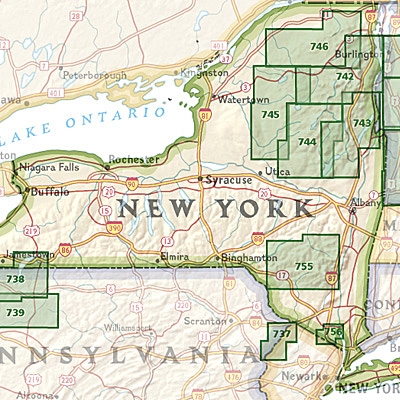
NAT GEO New York trail map
NAT GEO New York trail map

Producten op de overzichtskaart
Klik op een product om naar de detailpagina te gaan.
- Wandelkaart 738 Allegheny National Forest North - Nat Geo
- Wandelkaart 742 Adirondack Park - Lake Placid - Natgeo
- Wandelkaart 745 Adirondack Park - Old Forge & Oswegatchie
- Wandelkaart 746 Adirondack Park - Saranac & Paul Smiths
- Wandelkaart 747 Green Mountain National Forest- Vermont
- Wandelkaart 743 Adirondack Park - Lake George - Natgeo
- Wandelkaart 744 Adirondack Park - Northville & Raquette Lake
- Wandelkaart 748 Green Mountain National Forest
- Wandelkaart 756 Harriman- Bear Mountain & Sterling Forest parks
Artikelen uit dezelfde regio

Wandelkaart 745 Adirondack Park - Old Forge & Oswegatchie • 9781566954198
Topografische Wandelkaart 745 - Adirondack Park - Old Forge & Oswegatchie, New York State. Productomschjrijving: Adirondack park of mountains, een groter bebost deel van de staat New York. In dit geval gaat het over Old Forge, een bekende toegang tot het Old Forge deel van het pak. De locatie blijft een principieel toeristische regio, en zoals reeds vermeld, één van de westelijk gelegen to…
Reisgids New York secret - an unusual guide - Jonglez • 9782361952372
New York secret - an unusual guide - Jonglez Publishing Productinformation: Let Secret New York guide you around the unusual and unfamiliar. Step off the beaten track with this fascinating and unusual New York guide book and let our local experts show you the well-hidden treasures of this amazing city. Ideal for local inhabitants and curious travellers alike. The places included in our…

Reisgids New York city - Lonely Planet • 9781786570673
New York city - Lonely Planet Coverage Includes: Lower Manhattan & the Financial District, SoHo & Chinatown, East Village & Lower East Side, West Village, Chelsea & the Meatpacking District, Union Square, Flatiron District & Gramercy, Midtown, Upper East Side, Upper West Side & Central Park, Harlem & Upper Manhattan, Brooklyn, Queens. Product description: Epicenter of the arts. Dining…
Reisgids New York city - Lonely Planet • 9782816186406
New York city - Lonely Planet Déscription de product: Un guide de référence, à la fois pratique et culturel, pour un séjour inoubliable à New York. Une nouvelle édition tout en couleurs et avec de nombreuses photos. Un guide conçu pour les voyages en profondeur, avec un maximum d'informations pour organiser un séjour en fonction de ses intérêts, du temps et du budget disponible. Les pr…

Wandelkaart 742 Adirondack Park - Lake Placid - Natgeo • 9781566953573
TOPO Wandelkaart 742 - Adirondack Park - Lake Placid Productomschrijving : Adirondack park of mountains, een groter bebost deel van de staat New York. In dit geval gaat het over de locatie van Lake Placid, New York. Lake Placid is niet enkel een maar maar ook een kleine stad, in Essex County in New York. Engelse omschrijving : The largest park in the contiguous United States, Adirondac…