

Wandelkaart 157 St-David's & Haverfordwest - Wales - OSI
De traditionele Welsh steden van Pembroke & Milford Haven

Korte omschrijving
Wandelkaarten Pembrokeshire, Wales van Ordnance Survey. Ideaal voor tochten in Wales.
Wandelkaart St Davids & Haverfordwest - Wales OSI Productbeschrijving: De eigenschappen van het Pembrokeshire Coast Path sterkt zich op deze OS Landranger kaart 157 door langs de iconische k...

Specificaties
- Uitgever: Ordnance Survey
- ISBN-13: 9780319474808
- HOOFDCATEGORIEËN: Wandelkaart
- Activiteiten: Wandelen, Hiking & Trekking
- Regio: Pembrokeshire, Wales
- Land: Wales
- Waterafstotende kaart: Ordnance Survey ACTIVE Landranger Weatherproof Maps
- TOPO's & Stafkaarten: Topografisch wandelen
- Schaal: 1:50000
- Taal: Engels
- Reeks/Serie: Landranger ACTIVE series OSI
Volledige omschrijving
Wandelkaart St Davids & Haverfordwest - Wales OSI
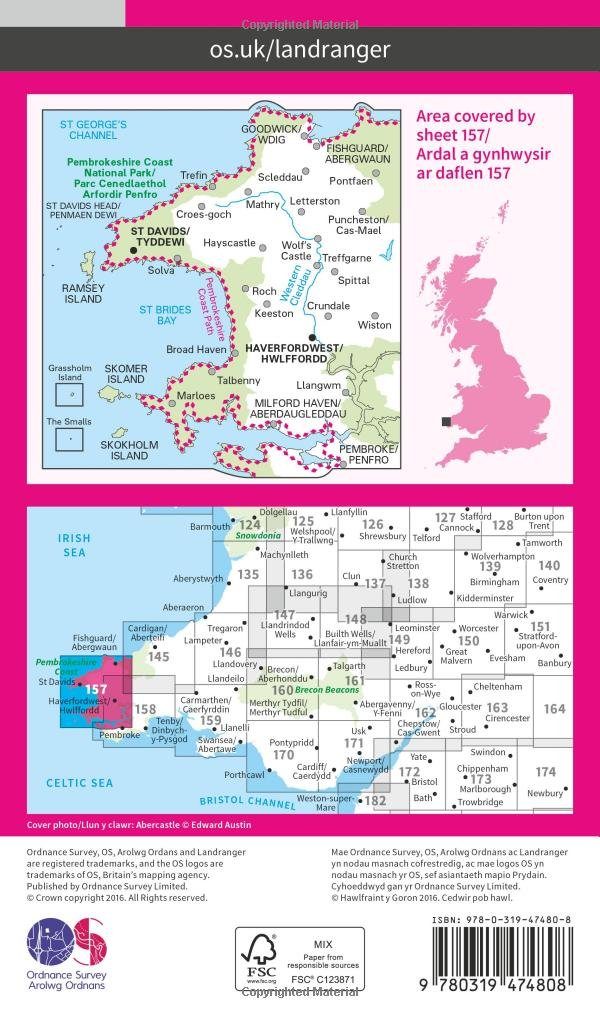
Productbeschrijving: De eigenschappen van het Pembrokeshire Coast Path sterkt zich op deze OS Landranger kaart 157 door langs de iconische kustlijn rond de landtong en St. Brides Bay, de traditionele Welsh steden van Pembroke, Milford Haven, Haverfordwest, St. David's en Goodwick. Hoogtepunten van St. David's Cathedral en de schitterende baai van Whitesands, waardoor de regio een fantastische toeristische bestemming werd met veel activiteiten.
De OS Landranger kaarten reeks heeft betrekking op Groot-Brittannië met 204 gedetailleerde kaarten, perfect voor dagtochten en korte pauzes. Elke kaart bevat alle informatie die u nodig heeft om dit lokaal gebied te leren kennen en omvat plaatsen van belang, toeristische informatie, picknickplaatsen en campings, plus doorgangsrechten informatie voor Engeland en Wales.
Productdiscription: The Pembrokeshire Coast Path features strongly on OS Landranger map 157 as it follows the iconic coastline around the headland and St. Brides Bay, passing through the traditional Welsh towns of Pembroke, Milford Haven, Haverfordwest, St. David's and Goodwick. Highlights include St. David's Cathedral and the stunning Whitesands Bay, making the region a fantastic tourist destination with many activities from horse riding to bird watching on offer. The map sheet also includes the Ramsey, Skokholm and Skomer islands.
The OS Landranger Map series covers Great Britain with 204 detailed maps, perfect for day trips and short breaks. Each map provides all the information you need to get to know your local area and includes places of interest, tourist information, picnic areas and camp sites, plus Rights of Way information for England and Wales.
Locatie op kaart
Gekoppelde artikelen

Wandelkaart 157 St-David's & Haverfordwest - Wales - OSI • 9780319262559
standaard versieWandelkaart St-David's & Haverfordwest - Wales - OSI Productbeschrijving: Pembrokeshire Coast Path op OS Landranger kaart 157, volgt de iconische kustlijn rond de landtong en St. Brides Bay, de traditionele Welsh steden van Pembroke, Milford Haven, Haverfordwest, St. David's en Goodwick passeren. De OS Landranger kaarten reeks heeft betrekking op Groot-Brittannië met 204 gedetailleerde kaa…

Wandelkaart 157 St-David's & Haverfordwest - Wales - OSI • 9780319474808
weatherproof versieWandelkaart St Davids & Haverfordwest - Wales OSI Productbeschrijving: De eigenschappen van het Pembrokeshire Coast Path sterkt zich op deze OS Landranger kaart 157 door langs de iconische kustlijn rond de landtong en St. Brides Bay, de traditionele Welsh steden van Pembroke, Milford Haven, Haverfordwest, St. David's en Goodwick. Hoogtepunten van St. David's Cathedral en de schitterende ba…
Overzichtskaarten

OSI Landranger & Landranger Active - Wales
OSI Landranger & Landranger Active - Wales

Producten op de overzichtskaart
Klik op een product om naar de detailpagina te gaan.
- Wandelkaart 108 Liverpool & Southport - England - OSI
- Wandelkaart 108 Liverpool- Merseyside England - OSI
- Wandelkaart 109 Greater Manchester England - OSI
- Wandelkaart 109 Manchester- Bolton & Warrington - OSI
- Wandelkaart 114 Anglesey & Ynys Môn- N.W. Wales - OSI
- Wandelkaart 114 Anglesey- North West Wales - OSI
- Wandelkaart 115 Snowdon & Caernarfon- Snowdonia NP - OSI
- Wandelkaart 115 Snowdon & Yr Wyddfa - Snowdonia NP - OSI
- Wandelkaart 116 Denbigh & Colwyn Bay - North Wales - OSI
- Wandelkaart 116 Denbigh & Colwyn Bay - North Wales - OSI
- Wandelkaart 117 Chester & Wrexham - Ellesmere Port - OSI
- Wandelkaart 117 Chester & Wrexham - West Cheshire - OSI
- Wandelkaart 118 Stoke-on-Trent & Macclesfield - OSI
- Wandelkaart 118 Stoke-on-Trent & Macclesfield - OSI
- Wandelkaart 123 Lleyn Peninsula - North Wales - OSI
- Wandelkaart 123 Lleyn Peninsula - North Wales - OSI
- Wandelkaart 124 Porthmadog & Dolgellau - N. Wales - OSI
- Wandelkaart 124 Porthmadog & Dolgellau - N. Wales - OSI
- Wandelkaart 125 Bala & Lake Vyrnwy- N. Wales - OSI
- Wandelkaart 125 Bala & Lake Vyrnwy- Gwynedd - OSI
- Wandelkaart 126 Shrewsbury & Oswestry - England - OSI
- Wandelkaart 126 Shrewsbury & Oswestry - England - OSI
- Wandelkaart 127 Stafford & Telford - Ironbridge England - OSI
- Wandelkaart 127 Stafford & Telford - Staffordshire England - OSI
- Wandelkaart 135 Aberystwyth & Machynlleth Wales - OSI
- Wandelkaart 135 Aberystwyth & Machynlleth Wales - OSI
- Wandelkaart 136 Newtown & Lllanidloes Wales - OSI
- Wandelkaart 136 Newtown & Llanidloes - OSI
- Wandelkaart 137 Ludlow & Church Stretton - England - OSI
- Wandelkaart 137 Ludlow & Church Stretton - England - OSI
- Wandelkaart 138 Kidderminster & Wyre Forest - OSI
- Wandelkaart 138 Kidderminster & Wyre Forest - OSI
- Wandelkaart 145 Cardigan & Mynydd Preseli - OSI
- Wandelkaart 145 Cardigan & Mynydd Preseli - OSI
- Wandelkaart 146 Lampeter & Llandovery - Ceredigion - OSI
- Wandelkaart 146 Lampeter & Llandovery - Ceredigion - OSI
- Wandelkaart 147 Elan valley & Builth Wells - Wales - OSI
- Wandelkaart 147 Elan Valley & Builth Wells - Wales - OSI
- Wandelkaart 148 Presteigne & Hay-on-Wye - S. Wales - OSI
- Wandelkaart 148 Presteigne & Hay-on-Wye - S. Wales - OSI
- Wandelkaart 149 Hereford & Leominster - England - OSI
- Wandelkaart 149 Hereford & Leominster - England - OSI
- Wandelkaart 150 Worcester & The Malverns - England - OSI
- Wandelkaart 150 Worcester & The Malverns - England - OSI
- Wandelkaart 157 St-David's & Haverfordwest - Wales - OSI
- Wandelkaart 157 St-David's & Haverfordwest - Wales - OSI
- Wandelkaart 158 Tenby & Pembroke - Wales - OSI
- Wandelkaart 158 Tenby & Pembroke - Wales - OSI
- Wandelkaart 159 Swansea & Gower- South Wales - OSI
- Wandelkaart 159 Swansea- Gower & Carmarthen - OSI
- Wandelkaart 160 Brecon Beacons NP - Powys Wales - OSI
- Wandelkaart 160 Brecon Beacons NP - Powys Wales - OSI
- Wandelkaart 161 Black Mountains & Brecon Beacons NP - OSI
- Wandelkaart 161 Black Mountains & Brecon Beacons NP - OSI
- Wandelkaart 162 Gloucester & Forest of Dean - OSI
- Wandelkaart 170 Vale of Glamorgan - Wales- OSI
- Wandelkaart 170 Vale of Glamorgan - Wales - OSI
- Wandelkaart 171 Cardiff & Newport - South Wales - OSI
- Wandelkaart 171 Cardiff & Newport - Pontypool South Wales - OSI
- Wandelkaart 172 Bristol & Bath- S.W. England - OSI
- Wandelkaart 172 Bristol- Bath & Thornbury- S.W. England - OSI

OSI Landranger & Landranger Active - Midden Engeland - Midland's
OSI Landranger & Landranger Active - Midden Engeland - Midland's

Producten op de overzichtskaart
Klik op een product om naar de detailpagina te gaan.
- Wandelkaart 102 Preston & Blackpool- Lancashire - OSI
- Wandelkaart 102 Preston & Blackpool- Lytham - OSI
- Wandelkaart 103 Blackburn & Burnley- N.W. England - OSI
- Wandelkaart 103 Blackburn- Burnley & Clitheroe - OSI
- Wandelkaart 104 Leeds & Bradford & Harrogate - OSI
- Wandelkaart 104 Leeds & Bradford - West Yorkshire - OSI
- Wandelkaart 105 York & Selby- North Yorkshire - OSI
- Wandelkaart 105 York & Selby- North Yorkshire - OSI
- Wandelkaart 106 Market Weighton- East Riding of Yorkshire - OSI
- Wandelkaart 106 Market Weighton- Goole- England - OSI
- Wandelkaart 107 Kingston upon Hull- Beverley - OSI
- Wandelkaart 107 Kingston upon Hull- Yorkshire - OSI
- Wandelkaart 108 Liverpool & Southport - England - OSI
- Wandelkaart 108 Liverpool & Merseyside - England - OSI
- Wandelkaart 109 Greater Manchester England - OSI
- Wandelkaart 109 Manchester- Bolton & Warrington - OSI
- Wandelkaart 110 Sheffield & Huddersfield - Glossop - OSI
- Wandelkaart 110 Sheffield & Huddersfield - Yorkshire - OSI
- Wandelkaart 111 Sheffield & Doncaster- Rotherham - OSI
- Wandelkaart 111 Sheffield & Doncaster England - OSI
- Wandelkaart 112 Scunthorpe & Gainsborough - OSI
- Wandelkaart 112 Scunthorpe & Gainsborough - OSI
- Wandelkaart 113 Grimsby- Louth & Market Rasen - OSI
- Wandelkaart 113 Grimsby- North East Lincolnshire - OSI
- Wandelkaart 114 Anglesey & Ynys Môn- N.W. Wales - OSI
- Wandelkaart 114 Anglesey- North West Wales - OSI
- Wandelkaart 115 Snowdon & Caernarfon- Snowdonia NP - OSI
- Wandelkaart 115 Snowdon & Yr Wyddfa - Snowdonia NP - OSI
- Wandelkaart 116 Denbigh & Colwyn Bay - North Wales - OSI
- Wandelkaart 116 Denbigh & Colwyn Bay - North Wales - OSI
- Wandelkaart 117 Chester & Wrexham - Ellesmere Port - OSI
- Wandelkaart 117 Chester & Wrexham - West Cheshire - OSI
- Wandelkaart 118 Stoke-on-Trent & Macclesfield - OSI
- Wandelkaart 118 Stoke-on-Trent & Macclesfield - OSI
- Wandelkaart 119 Buxton & Matlock- Derbyshire - OSI
- Wandelkaart 119 Buxton- Matlock & Chesterfield - OSI
- Wandelkaart 120 Mansfield & Sherwood Forest - OSI
- Wandelkaart 120 Mansfield - Nottinghamshire - OSI
- Wandelkaart 121 Lincoln & Newark-on-Trent- England - OSI
- Wandelkaart 121 Lincoln & Newark-on-Trent- England - OSI
- Wandelkaart 122 Skegness & Horncastle - England - OSI
- Wandelkaart 122 Skegness & Horncastle - England - OSI
- Wandelkaart 123 Lleyn Peninsula - North Wales - OSI
- Wandelkaart 123 Lleyn Peninsula - North Wales - OSI
- Wandelkaart 124 Porthmadog & Dolgellau - N. Wales - OSI
- Wandelkaart 124 Porthmadog & Dolgellau - N. Wales - OSI
- Wandelkaart 125 Bala & Lake Vyrnwy- Gwynedd - OSI
- Wandelkaart 125 Bala & Lake Vyrnwy- N. Wales - OSI
- Wandelkaart 126 Shrewsbury & Oswestry - England - OSI
- Wandelkaart 126 Shrewsbury & Oswestry - England - OSI
- Wandelkaart 127 Stafford & Telford - Ironbridge England - OSI
- Wandelkaart 127 Stafford & Telford - Staffordshire England - OSI
- Wandelkaart 128 Derby & Burton upon Trent - England - OSI
- Wandelkaart 128 Derby & Burton upon Trent - England - OSI
- Wandelkaart 129 Nottingham & Loughborough - England - OSI
- Wandelkaart 129 Nottingham & Loughborough - England - OSI
- Wandelkaart 130 Grantham- Lincolnshire- England - OSI
- Wandelkaart 130 Grantham- Sleaford & Bourne - OSI
- Wandelkaart 131 Boston & Spalding - England - OSI
- Wandelkaart 131 Boston & Spalding - Lincolshire England - OSI
- Wandelkaart 132 King's Lynn & Fakenham - England - OSI
- Wandelkaart 133 North East Norfolk - OSI
- Wandelkaart 133 North East Norfolk - Cromer - Wroxham - OSI
- Wandelkaart 134 Norwich & The Broads NP - OSI
- Wandelkaart 134 Norwich- The Broads NP & Great Yarmouth - OSI
- Wandelkaart 135 Aberystwyth & Machynlleth Wales - OSI
- Wandelkaart 135 Aberystwyth & Machynlleth Wales - OSI
- Wandelkaart 137 Ludlow & Church Stretton - England - OSI
- Wandelkaart 137 Ludlow & Church Stretton - England - OSI
- Wandelkaart 138 Kidderminster & Wyre Forest - OSI
- Wandelkaart 138 Kidderminster & Wyre Forest - OSI
- Wandelkaart 139 Birmingham & Wolverhampton - OSI
- Wandelkaart 139 Birmingham & Wolverhampton - OSI
- Wandelkaart 140 Leicester- Coventry & Rugby - OSI
- Wandelkaart 140 Leicester- Coventry & Rugby - OSI
- Wandelkaart 140 Kettering & Corby- England - OSI
- Wandelkaart 141 Kettering & Corby- England - OSI
- Wandelkaart 142 Peterborough & Market Deeping - England
- Wandelkaart 142 Peterborough & Market Deeping- England
- Wandelkaart 143 Ely & Wisbech- Cambridgeshire - OSI
- Wandelkaart 143 Ely- Wisbech & Downham - OSI
- Wandelkaart 144 Thetford & Breckland- Norfolk - OSI
- Wandelkaart 144 Thetford- Breckland & Wymondham - OSI
- Wandelkaart 145 Cardigan & Mynydd Preseli - OSI
- Wandelkaart 145 Cardigan & Mynydd Preseli - OSI
- Wandelkaart 146 Lampeter & Llandovery - Ceredigion - OSI
- Wandelkaart 146 Lampeter & Llandovery - Ceredigion - OSI
- Wandelkaart 147 Elan Valley & Builth Wells - Wales - OSI
- Wandelkaart 147 Elan valley & Builth Wells - Wales - OSI
- Wandelkaart 148 Presteigne & Hay-on-Wye - S. Wales - OSI
- Wandelkaart 148 Presteigne & Hay-on-Wye - S. Wales - OSI
- Wandelkaart 149 Hereford & Leominster - England - OSI
- Wandelkaart 149 Hereford & Leominster - England - OSI
- Wandelkaart 150 Worcester & The Malverns - England - OSI
- Wandelkaart 150 Worcester & The Malverns - England - OSI
- Wandelkaart 151 Stratford-upon-Avon & Warwick - OSI
- Wandelkaart 151 Stratford-upon-Avon- England - OSI
- Wandelkaart 152 Northampton & Milton Keynes - OSI
- Wandelkaart 152 Northampton & Milton Keynes - OSI
- Wandelkaart 153 Bedford & Huntingdon- England - OSI
- Wandelkaart 153 Bedford- Huntingdon & St-Neots - OSI
- Wandelkaart 154 Cambridge & Newmarket - England - OSI
- Wandelkaart 154 Cambridge & Newmarket - England - OSI
- Wandelkaart 155 Bury St-Edmunds & Stowmarket - OSI
- Wandelkaart 155 Bury St-Edmunds & Sudbury - OSI
- Wandelkaart 156 Saxmundham & Aldeburgh - OSI
- Wandelkaart 156 Saxmundham- Aldeburgh & Southwold - OSI
- Wandelkaart 157 St-David's & Haverfordwest - Wales - OSI
- Wandelkaart 157 St-David's & Haverfordwest - Wales - OSI
- Wandelkaart 158 Tenby & Pembroke - Wales - OSI
- Wandelkaart 158 Tenby & Pembroke - Wales - OSI
- Wandelkaart 159 Swansea & Gower - South Wales - OSI
- Wandelkaart 159 Swansea- Gower & Carmarthen - OSI
- Wandelkaart 160 Brecon Beacons NP - Powys Wales - OSI
- Wandelkaart 160 Brecon Beacons NP - Powys Wales - OSI
- Wandelkaart 161 Black Mountains & Brecon Beacons NP - OSI
- Wandelkaart 161 Black Mountains & Brecon Beacons NP - OSI
- Wandelkaart 162 Gloucester & Forest of Dean - OSI
- Wandelkaart 163 Cheltenham & Cirencester - England - OSI
- Wandelkaart 163 Cheltenham & Cirencester - England - OSI
- Wandelkaart 164 Oxford & Chipping Norton - England - OSI
- Wandelkaart 164 Oxford & Chipping Norton - England - OSI
- Wandelkaart 165 Aylesbury & Leighton Buzzard - OSI
- Wandelkaart 165 Aylesbury & Leighton Buzzard - OSI
- Wandelkaart 166 Luton- Hertford & Hitchin - OSI
- Wandelkaart 166 Luton- Hertford & Hitchin- Bedfordshire - OSI
- Wandelkaart 167 Chelmsford & Harlow- Essex England - OSI
- Wandelkaart 167 Chelmsford- Harlow & Bishop's - OSI
- Wandelkaart 168 Colchester- Halstead & Maldon - OSI
- Wandelkaart 168 Colchester- Halstead & Maldon- England - OSI
- Wandelkaart 169 Ipswich & The Naze- England - OSI
- Wandelkaart 169 Ipswich & The Naze- England - OSI
Artikelen uit dezelfde regio

Wandelkaart 158 Tenby & Pembroke - Wales - OSI • 9780319474815
Wandelkaart Tenby & Pembroke in Pembrokeshire Wales Productbeschrijving: Deze OS Landranger kaart 158 omvat Tenby & Pembroke, alsook Kilgetty, Freystrop, Yerbeston, Milford Haven, Wolfsdale, Llandissilio, het Nationaal Park van Pembrokeshire Coast en de Pembrokeshire Coast Path. De OS Landranger kaarten reeks heeft betrekking op Groot-Brittannië met 204 gedetailleerde kaarten, perfect voo…
Wandelgids Day Walks on the Pembrokeshire Coast - Vertebrate publ • 9781910240984
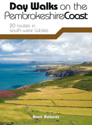
Day Walks on the Pembrokeshire Coast - Vertebrate Productomschrijving: 20 routes in south-west Wales Day Walks on the Pembrokeshire Coast features 20 classic coastal routes between 6.5 miles and 13 miles (10.4km and 20.8km) in length, suitable for hillwalkers of all abilities. Local author and walker Harri Roberts shares his favourite walks in the national park, including a meander al…

Wandelgids Park Rangers Favourite Walks Pembrokeshire - Collins • 9780008462734
Park Rangers Favourite Walks Pembrokeshire coast - Collins Productomschrijving: Wandelgids voor het Pembrokeshire Coast National Park, met 20 beste routes uitgekozen door de parkwachters. Elke wandeling varieert in lengte van 2 tot 10 km en kan worden voltooid in minder dan 4 uur. Engelse omschrijving: Walking guide to the Pembrokeshire Coast National Park, with 20 best routes chosen b…

Wandelkaart OL036 Pembrokeshire National Park South - OS • 9780319242759
Wandelkaart Pembrokeshire National Park South - OS Productomschrijving: Pembrokeshire National Park South Ontdek de OL-serie van Ordnance Survey: De OL-serie (Outdoor Leisure) van Ordnance Survey is dé referentie voor wie gaat wandelen op de Britse eilanden. Deze topografische kaarten maken deel uit van de Explorer-reeks en bieden ongeëvenaarde nauwkeurigheid en detail op een schaal …

Wandelkaart 158 Tenby & Pembroke - Wales - OSI • 9780319262566
Wandelkaart Tenby & Pembroke in Wales Productbeschrijving: Deze OS Landranger kaart 158 van Tenby & Pembroke omvat ook Kilgetty, Freystrop, Yerbeston, Milford Haven, Wolfsdale, Llandissilio, het Nationaal Park van Pembrokeshire Coast en de Pembrokeshire Coast Path. De OS Landranger kaarten reeks heeft betrekking op Groot-Brittannië met 204 gedetailleerde kaarten, perfect voor dagtochten e…