

Wandelkaart 171 Cardiff & Newport - South Wales - OSI
Omvat Cardiff- Newport en Pontypool

Korte omschrijving
Wandelkaarten South Wales van Ordnance Survey. Ideaal voor tochten in Wales.
Wandelkaart Cardiff & Newport - South Wales Productbeschrijving: Als een compacte en levendige stad is Cardiff een spannende plek om te vertroeven. OS Landranger kaart 171 dekt Cardiff, Newp...

Specificaties
- Uitgever: Ordnance Survey
- ISBN-13: 9780319262696
- HOOFDCATEGORIEËN: Wandelkaart
- Activiteiten: Wandelen, Hiking & Trekking
- Regio: South Wales
- Land: Wales
- TOPO's & Stafkaarten: Topografisch wandelen
- Schaal: 1:50000
- Taal: Engels
- Reeks/Serie: Landranger Series OSI
Volledige omschrijving
Wandelkaart Cardiff & Newport - South Wales
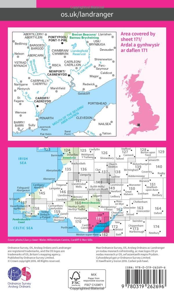
Productbeschrijving: Als een compacte en levendige stad is Cardiff een spannende plek om te vertroeven. OS Landranger kaart 171 dekt Cardiff, Newport en Pontypool en de monding van de Severn. Het heeft een schat aan sport, culturele, en entertainment attracties variërend van de studio's van BBC Wales naar de kathedraal van Llandaff.
De OS Landranger kaarten reeks heeft betrekking op Groot-Brittannië met 204 gedetailleerde kaarten, perfect voor dagtochten en korte pauzes. Elke kaart bevat alle informatie die u nodig heeft om dit lokaal gebied te leren kennen en omvat plaatsen van belang, toeristische informatie, picknickplaatsen en campings, plus doorgangsrechten informatie voor Engeland en Wales.
Productdiscription: As a compact and vibrant city, Cardiff is an exciting place to be. OS Landranger map 171 covers Cardiff (Caerdydd), Newport (Casnewydd) and Pontypool (Pont-y-pwl) and the mouth of the Severn. It has a wealth of sport, cultural and entertainment attractions ranging from the BBC Wales studios to Llandaff Cathedral and the city never has a shortage of festivals and events.
The OS Landranger Map series covers Great Britain with 204 detailed maps, perfect for day trips and short breaks. Each map provides all the information you need to get to know your local area and includes places of interest, tourist information, picnic areas and camp sites, plus Rights of Way information for England and Wales.
Locatie op kaart
Gekoppelde artikelen

Wandelkaart 171 Cardiff & Newport - South Wales - OSI • 9780319262696
standaard versieWandelkaart Cardiff & Newport - South Wales Productbeschrijving: Als een compacte en levendige stad is Cardiff een spannende plek om te vertroeven. OS Landranger kaart 171 dekt Cardiff, Newport en Pontypool en de monding van de Severn. Het heeft een schat aan sport, culturele, en entertainment attracties variërend van de studio's van BBC Wales naar de kathedraal van Llandaff. De OS Lan…

Wandelkaart 171 Cardiff & Newport - Pontypool South Wales - OSI • 9780319474945
weatherproof versieWandelkaart Cardiff- Newport & Pontypool - South Wales Productbeschrijving: Als een compacte en levendige stad is Cardiff een spannende plek om te troeben. OS Landranger kaart 171 dekt Cardiff (Caerdydd), Newport (Casnewydd) en Pontypool (Pont-y-pwl) en de monding van de Severn. Het heeft een schat aan sport. De OS Landranger kaarten reeks heeft betrekking op Groot-Brittannië met 204 gedet…
Overzichtskaarten

OSI Landranger & Landranger Active - Wales
OSI Landranger & Landranger Active - Wales

Producten op de overzichtskaart
Klik op een product om naar de detailpagina te gaan.
- Wandelkaart 108 Liverpool & Southport - England - OSI
- Wandelkaart 108 Liverpool- Merseyside England - OSI
- Wandelkaart 109 Greater Manchester England - OSI
- Wandelkaart 109 Manchester- Bolton & Warrington - OSI
- Wandelkaart 114 Anglesey & Ynys Môn- N.W. Wales - OSI
- Wandelkaart 114 Anglesey- North West Wales - OSI
- Wandelkaart 115 Snowdon & Caernarfon- Snowdonia NP - OSI
- Wandelkaart 115 Snowdon & Yr Wyddfa - Snowdonia NP - OSI
- Wandelkaart 116 Denbigh & Colwyn Bay - North Wales - OSI
- Wandelkaart 116 Denbigh & Colwyn Bay - North Wales - OSI
- Wandelkaart 117 Chester & Wrexham - Ellesmere Port - OSI
- Wandelkaart 117 Chester & Wrexham - West Cheshire - OSI
- Wandelkaart 118 Stoke-on-Trent & Macclesfield - OSI
- Wandelkaart 118 Stoke-on-Trent & Macclesfield - OSI
- Wandelkaart 123 Lleyn Peninsula - North Wales - OSI
- Wandelkaart 123 Lleyn Peninsula - North Wales - OSI
- Wandelkaart 124 Porthmadog & Dolgellau - N. Wales - OSI
- Wandelkaart 124 Porthmadog & Dolgellau - N. Wales - OSI
- Wandelkaart 125 Bala & Lake Vyrnwy- N. Wales - OSI
- Wandelkaart 125 Bala & Lake Vyrnwy- Gwynedd - OSI
- Wandelkaart 126 Shrewsbury & Oswestry - England - OSI
- Wandelkaart 126 Shrewsbury & Oswestry - England - OSI
- Wandelkaart 127 Stafford & Telford - Ironbridge England - OSI
- Wandelkaart 127 Stafford & Telford - Staffordshire England - OSI
- Wandelkaart 135 Aberystwyth & Machynlleth Wales - OSI
- Wandelkaart 135 Aberystwyth & Machynlleth Wales - OSI
- Wandelkaart 136 Newtown & Lllanidloes Wales - OSI
- Wandelkaart 136 Newtown & Llanidloes - OSI
- Wandelkaart 137 Ludlow & Church Stretton - England - OSI
- Wandelkaart 137 Ludlow & Church Stretton - England - OSI
- Wandelkaart 138 Kidderminster & Wyre Forest - OSI
- Wandelkaart 138 Kidderminster & Wyre Forest - OSI
- Wandelkaart 145 Cardigan & Mynydd Preseli - OSI
- Wandelkaart 145 Cardigan & Mynydd Preseli - OSI
- Wandelkaart 146 Lampeter & Llandovery - Ceredigion - OSI
- Wandelkaart 146 Lampeter & Llandovery - Ceredigion - OSI
- Wandelkaart 147 Elan valley & Builth Wells - Wales - OSI
- Wandelkaart 147 Elan Valley & Builth Wells - Wales - OSI
- Wandelkaart 148 Presteigne & Hay-on-Wye - S. Wales - OSI
- Wandelkaart 148 Presteigne & Hay-on-Wye - S. Wales - OSI
- Wandelkaart 149 Hereford & Leominster - England - OSI
- Wandelkaart 149 Hereford & Leominster - England - OSI
- Wandelkaart 150 Worcester & The Malverns - England - OSI
- Wandelkaart 150 Worcester & The Malverns - England - OSI
- Wandelkaart 157 St-David's & Haverfordwest - Wales - OSI
- Wandelkaart 157 St-David's & Haverfordwest - Wales - OSI
- Wandelkaart 158 Tenby & Pembroke - Wales - OSI
- Wandelkaart 158 Tenby & Pembroke - Wales - OSI
- Wandelkaart 159 Swansea & Gower- South Wales - OSI
- Wandelkaart 159 Swansea- Gower & Carmarthen - OSI
- Wandelkaart 160 Brecon Beacons NP - Powys Wales - OSI
- Wandelkaart 160 Brecon Beacons NP - Powys Wales - OSI
- Wandelkaart 161 Black Mountains & Brecon Beacons NP - OSI
- Wandelkaart 161 Black Mountains & Brecon Beacons NP - OSI
- Wandelkaart 162 Gloucester & Forest of Dean - OSI
- Wandelkaart 170 Vale of Glamorgan - Wales- OSI
- Wandelkaart 170 Vale of Glamorgan - Wales - OSI
- Wandelkaart 171 Cardiff & Newport - South Wales - OSI
- Wandelkaart 171 Cardiff & Newport - Pontypool South Wales - OSI
- Wandelkaart 172 Bristol & Bath- S.W. England - OSI
- Wandelkaart 172 Bristol- Bath & Thornbury- S.W. England - OSI
Artikelen uit dezelfde regio

Landkaart Wegenkaart 1 West Country & Wales Zuid - AA • 9780749584061
Wegenkaart West Country & Wales Zuid - AA Productomschrijving: AA Road Map West Country & South Wales is a practical and slimline, foldable map from the experts at the AA. Encased in a durable, weatherproof cover, the mapping is produced at a scale of 3 miles to 1 inch (1:200,000 / 2km to 1cm) combining clear design, an easy-to-read scale and more road detail to ensure that you never lose…

Wandelkaart 166 Rhondda & Merthyr Tydfil - OSI • 9780319243596
Wandelkaart Rhondda & Merthyr Tydfil - South Wales Productbeschrijving: Kaart nummer 166 in de OS Explorer kaart reeks is de ideale kaart voor het ontdekken van de enorme ruimte van Rhondda en Merthyr Tydfil in Zuid-Wales. Net ten zuiden van de Brecon Beacons heeft dit gebied prachtige natuurschoon en vele wandelingen om te waarderen. Hoogtepunten van het gebied zijn onder andere: Aberdare…
Wandelgids 50 walks in the Brecon Beacons & South Wales - AA • 9780749583705
Wandelgids Brecon Beacons & South Wales - AA Productomschrijving: De Brecon Beacons in Wales vormen een waar paradijs voor wandelaars. Met zijn uitgestrekte landschappen, ruige bergen en diepe valleien biedt dit nationale park meer dan genoeg om de avontuurlijke wandelaar bezig te houden. Stel je voor dat er 50 wandelroutes zijn, elk met hun eigen charme en uitdaging, variërend van eenvoud…

Reisgids South Wales - Bradt Travel Guides • 9781784778378
Reisgids Wales South - Bradt Productomschrijving: Deze nieuwe Bradt-gids is de eerste die uitsluitend gewijd is aan een specifiek deel van Wales en omvat het zuidelijke derde deel van het land. Deze gids bestrijkt Monmouthshire, Glamorgan, Carmarthenshire, Pembrokeshire en het Brecon Beacons National Park en biedt een diepgaande beschrijving van een breed scala aan attracties. Voor wandela…
Wandelkaart 187 Llandovery- South Wales - OSI • 9780319243800
Wandelkaart Llandovery - South Wales Omvat ook: Llanwrtyd Wells & Llyn Brianne. Productbeschrijving: OS Explorer kaart blad 187 toont Claerwen Resevior aan de Tywi Forest en Llandovery. De Wereldkampioenschappen Bog snorkelen worden er jaarlijks gehouden in de buurt van Llanwrtyd Wells. De OS Explorer kaart voor Llandovery is beschikbaar in zowel de standaard papieren versie als de wee…