
Wandelkaart 221 Coventry & Warwickshire - OSI
Omvat Coventry- Warwick & Royal Leamington Spa

Korte omschrijving
Wandelkaart Coventry & Warwickshire - England Productbeschrijving: Royal Leamington Spa & Kenilworth. 221 / Coventry & Warwickshire, England - OS Explorer kaart 221 dekt Coventry, Warwi...

Specificaties
- Uitgever: Ordnance Survey
- ISBN-13: 9780319244142
- HOOFDCATEGORIEËN: Wandelkaart
- Activiteiten: Wandelen, Hiking & Trekking
- Regio: Warwickshire, West Midlands
- Land: England
- Schaal: 1:25000
- Afmeting: 13x23
- Taal: Engels
- Reeks: Explorer Series
Volledige omschrijving
Wandelkaart Coventry & Warwickshire - England
Productbeschrijving: Royal Leamington Spa & Kenilworth.
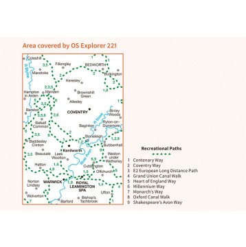
221 / Coventry & Warwickshire, England - OS Explorer kaart 221 dekt Coventry, Warwick, Royal Leamington Spa en de omliggende gebieden. Warwick Castle en vervolgens de rivier de Avon en Fort Lunt Roamn in de buurt van Coventry. De OS Explorer kaart voor Coventry & Warwick is beschikbaar in zowel de standaard papieren versie als de weerbestendige 'Actief' versie.
221 / Coventry & Warwickshire, England - OS Explorer Map sheet 221 covers Coventry, Warwick, Royal Leamington Spa and the surrounding areas. Explore Warwick Castle, and then continue your adventure up the River Avon, or visit the Roamn Lunt Fort near Coventry. The OS Explorer map for Coventry & Warwick is available in both the standard paper version and weatherproof 'Active' version.
Locatie op kaart
Gekoppelde artikelen

Wandelkaart 221 Coventry & Warwickshire - OSI • 9780319244142
standaard versieWandelkaart Coventry & Warwickshire - England Productbeschrijving: Royal Leamington Spa & Kenilworth. 221 / Coventry & Warwickshire, England - OS Explorer kaart 221 dekt Coventry, Warwick, Royal Leamington Spa en de omliggende gebieden. Warwick Castle en vervolgens de rivier de Avon en Fort Lunt Roamn in de buurt van Coventry. De OS Explorer kaart voor Coventry & Warwick is beschikbaa…

Wandelkaart 221 Coventry & Warwick- West Midlands - OSI • 9780319470930
weatherproof versieWandelkaart Coventry & Warwick - West Midlands England Productbeschrijving: OS Explorer kaart 221 omvat Coventry, Warwick, Royal Leamington Spa en de omliggende gebieden. Ontdek Warwick Castle, en zet vervolgens uw avontuur door langs de rivier de Avon, of bezoek het Fort Lunt Roamn in de buurt van Coventry. De OS Explorer kaart voor Coventry & Warwick is beschikbaar in zowel de standaard …
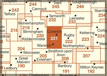
Overzichtskaarten

OSI Explorer & Explorer Active - Midden Engeland - Midlands
OSI Explorer & Explorer Active - Midden Engeland - Midlands

Producten op de overzichtskaart
Klik op een product om naar de detailpagina te gaan.
- Wandelkaart 179 Gloucester- Cheltenham & Stroud - OSI
- Wandelkaart 180 Oxford- England - OSI
- Wandelkaart 181 Chiltern Hills North AONB- Wycombe - OSI
- Wandelkaart 182 St-Albans & Hatfield- Hertfordshire - OSI
- Wandelkaart 189 Hereford & Ross-on-Wye- England - OSI
- Wandelkaart 190 Malvern Hills AONB & Bredon Hill - OSI
- Wandelkaart 191 Banbury- Bicester & Chipping Norton- OSI
- Wandelkaart 192 Buckingham & Milton Keynes - OSI
- Wandelkaart 193 Luton & Stevenage- Bedfordshire - OSI
- Wandelkaart 194 Hertford & Bishop's Stortford - OSI
- Wandelkaart 202 Leominster & Bromyard Hererfordshire - OSI
- Wandelkaart 203 Ludlow & Shropshire Hills AONB - OSI
- Wandelkaart 204 Worcester & Droitwich Spa - OSI
- Wandelkaart 205 Stratford-upon-Avon & Evesham - OSI
- Wandelkaart 206 Edge Hill & Fenny Compton - OSI
- Wandelkaart 207 Newport Pagnell & Northampton - OSI
- Wandelkaart 208 Bedford & St Neots- Bedforeshire - OSI
- Wandelkaart 209 Cambridge - England - OSI
- Wandelkaart 217 Long Mynd & Wenlock Edge - OSI
- Wandelkaart 218 Kidderminster & Wyre Forest - OSI
- Wandelkaart 219 Wolverhampton & Dudley - OSI
- Wandelkaart 220 Birmingham- West Midlands - OSI
- Wandelkaart 221 Coventry & Warwickshire - OSI
- Wandelkaart 222 Rugby & Daventry- Warwickshire - OSI
- Wandelkaart 223 Northampton & Market Harborough - OSI
- Wandelkaart 224 Corby- Kettering & Wellingborough - OSI
- Wandelkaart 225 Huntingdon & St Ives - OSI
- Wandelkaart 227 Peterborough- Cambridgeshire England - OSI
- Wandelkaart 228 March- Ely- Chatteris & Littleport - OSI
- Wandelkaart 232 Nuneaton & Tamworth- Warwickshire - OSI
- Wandelkaart 233 Leicester & Hinckley England - OSI
- Wandelkaart 234 Rutland Water & Stamford- Oakham - OSI
- Wandelkaart 235 Wisbech & Peterborough North - OSI
- Wandelkaart 241 Shrewsbury- shropshire England - OSI
- Wandelkaart 242 Telford- Ironbridge & the Wrekin - OSI
- Wandelkaart 243 Market Drayton- Schropshire - OSI
- Wandelkaart 244 Cannock Chase & Chasewater- Severn - OSI
- Wandelkaart 245 National Forest- Burton-upon-Trent - OSI
- Wandelkaart 245 National Forest - OSI
- Wandelkaart 246 Loughborough- Leicestershire England - OSI
- Wandelkaart 247 Grantham- Lincolnshire - OSI
- Wandelkaart 248 Bourne & Heckington- lincolnshire - OSI
- Wandelkaart 249 Spalding & Holbeach- Lincolnshire - OSI
- Wandelkaart 257 Crewe & Nantwich & Cheshire East - OSI
- Wandelkaart 258 Stoke-on-Trent & Newcastle-under-Lyme- OSI
- Wandelkaart 259 Derby & Utoxeter- Derbyshire - OSI
- Wandelkaart 260 Nottingham & Vale of Belvoir - OSI
- Wandelkaart 261 Boston & Lincolnshire- England - OSI
- Wandelkaart 267 Northwich & Delamere Forest - OSI
- Wandelkaart 268 Wilmslow- Macclesfield & Congleton - OSI
- Wandelkaart 269 Chesterfield & Alfreton- Derbyshire- OSI
- Wandelkaart 270 Sherwood Forest- Nottinghamshire - OSI
- Wandelkaart 271 Newark-on-Trent- Nottinghampshire - OSI
- Wandelkaart 272 Lincoln- England - OSI
- Wandelkaart 273 Lincolnshire Wolds South- England - OSI
- Wandelkaart 274 Skegness- Alford & Spilsby - OSI
- Wandelkaart 275 Liverpool- South West England - OSI
- Wandelkaart 276 Bolton- Wigan & Warrington- Machester - OSI
- Wandelkaart 277 Manchester & Salford - OSI
- Wandelkaart 278 Sheffield & Barnsley- South Yorkshire - OSI
- Wandelkaart 279 Doncaster- South Yorkshire - OSI
- Wandelkaart 280 Isle of Axholme- Lincolnshire - OSI
- Wandelkaart 281 Ancholme Valley- Lincolnshire - OSI
- Wandelkaart 282 Lincolnshire Wolds North- England - OSI
- Wandelkaart 283 Louth & Mablethorpe- Lincolnshire - OSI
- Wandelkaart 284 Grimsby- Cleethorpes & Immingham - OSI
Artikelen uit dezelfde regio

Wandelkaart 205 Stratford-upon-Avon & Evesham - OSI • 9780319243985
Wandelkaart Stratford-upon-Avon & Evesham - Warwickshire Omvat ook: Alcester. Productbeschrijving: Kaart nummer 205 in de OS Explorer kaarten reeks beslaat een gebied in de Midlands van Engeland. Dit is een gebied die deel uit maakt van de Cotswolds AONB, alsmede de Monarch en Centenary Way wandelroutes naar het zuiden. Andere steden die zijn opgenomen in het verdragsgebied omvatten Al…

Fietskaart & Mtb kaart The Cotswolds - Goldeneye • 9781859652589
Fietskaart en Mtb kaart - The Cotswolds - Goldeneye Productomschrijving: De Cotswolds is een AONB streek, (Area of Outstanding Natural Beauty) in centraal Engeland. Het gebied omvat de graafschappen Somerset, Warwickshire, Wiltshire, Oxfordshire & Worcestershire, maar het grootste deel ligt in Gloucestershire. Er wordt sinds eeuwen kalksteen uit de steengroeven gewonnen in deze regio, en d…

Wandelgids Guide to the Cotswolds AONB - AA • 9780749579418
Wandelgids - Guide to the Cotswolds AONB - AA Productomschrijving: The Cotswolds zijn een regio van uitmuntend natuurlijk schoon, of in andere woorden, "Area of Outstanding Natural Beauty". Zo noemen de britten hun meest geliefde regio's. WIj spreken oven nationale parken or regionale parken, terwijl de britten er eveneens over beschikken, maar de AONB's gaan voor op de rest. Talloze route…

Wandelkaart 206 Edge Hill & Fenny Compton - OSI • 9780319243992
Wandelkaart Edge Hill & Fanny Compton - Warwickshire Productbeschrijving: Badby, Kineton & Middle Tysoe. 206 / Edge Hill & Fenny Compton, Warwickshire, England - Kaart nummer 206 in de OS Explorer kaart reeks is ideaal voor het ontdekken van het noordelijke deel van de Cotswolds. Dit gebied van uitzonderlijke natuurlijke schoonheid AONB kan worden bezocht dmv het aflopen van de Centen…

Reisgids Cotswolds England - Rough Guides • 9780241308752
Reisgids Cotswolds England - Rough Guides Productomschrijving: The Rough Guide to the Cotswolds AONB is your definitive handbook to one of the most beautiful and diverse holiday destinations in the UK. From stately homes and wildlife parks to modern art galleries, country walks and adventure sports, there is a section that introduces all of the regions’ highlights. For every town and v…