

Wandelkaart 269 Chesterfield & Alfreton- Derbyshire- OSI
Hier zijn een aantal parken te ontdekken


Korte omschrijving
Wandelkaarten Derbyshire, England van Ordnance Survey. Ideaal voor tochten in England.
Wandelkaart Chesterfield & Alfreton - Derbyshire England Productbeschrijving: Sutton in Ashfield & Bolsover. 269 / Chesterfield & Alfreton, Derbyshire, England - OS Explorer kaart 269 de...

Specificaties
- Uitgever: Ordnance Survey
- ISBN-13: 9780319244661
- HOOFDCATEGORIEËN: Wandelkaart
- Activiteiten: Wandelen, Hiking & Trekking
- Regio: Derbyshire, England
- Land: England
- TOPO's & Stafkaarten: Topografisch wandelen
- Schaal: 1:25000
- Taal: Engels
- Reeks/Serie: Explorer Series OS
- De Engelse Graafschappen: Derbyshire
Volledige omschrijving
Wandelkaart Chesterfield & Alfreton - Derbyshire England
Productbeschrijving: Sutton in Ashfield & Bolsover.
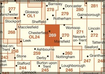
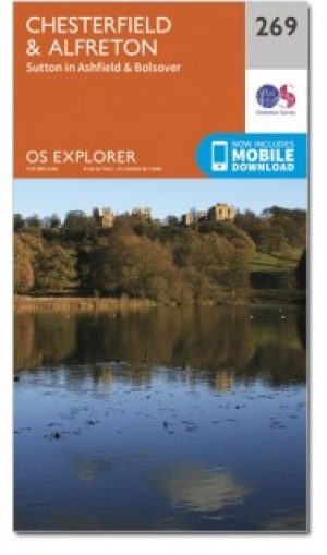
269 / Chesterfield & Alfreton, Derbyshire, England - OS Explorer kaart 269 dekt Chesterfield, Sutton in Ashfield en Alfreton. Hier zijn een aantal parken om te ontdekken, evenals deel van de Trans Pennine Trail. De five pits Trail te Grassmoor is open voor fietsers, wandelaars en ruiters. De OS Explorer kaart voor Chesterfield & Alfreton is beschikbaar in zowel de standaard papieren versie Als de weerbestendige 'Actief' versie.
269 / Chesterfield & Alfreton, Derbyshire, England - OS Explorer Map 269 covers Chesterfield, Sutton in Ashfield and Alfreton. There are a number of Country Parks to discover, as well as part of the Trans Pennine Trail. The Five Pits Trail at Grassmoor is surfaced and open to cyclists, walkers and horse riders. The OS Explorer map for Chesterfield & Alfreton is available in both the standard paper version and weatherproof 'Active' version.
Locatie op kaart
Gekoppelde artikelen
Wandelkaart 269 Chesterfield & Alfreton- Derbyshire- OSI • 9780319244661
standaard versieWandelkaart Chesterfield & Alfreton - Derbyshire England Productbeschrijving: Sutton in Ashfield & Bolsover. 269 / Chesterfield & Alfreton, Derbyshire, England - OS Explorer kaart 269 dekt Chesterfield, Sutton in Ashfield en Alfreton. Hier zijn een aantal parken om te ontdekken, evenals deel van de Trans Pennine Trail. De five pits Trail te Grassmoor is open voor fietsers, wandelaars e…

Wandelkaart 269 Chesterfield & Alfreton- Derbyshire - OSI • 9780319471418
weatherproof versieWandelkaart Chesterfield & Alfreton - Derbyshire East Midlands Omvat ook: Sutton in Ashfield & Bolsover. Productbeschrijving: OS Explorer kaart 269 omvat Chesterfield, Sutton in Ashfield en Alfreton. Er vallen een aantal parken om te ontdekken, evenals deel van de Trans Pennine Trail. De Five Pits Trail in Grassmoor is open voor fietsers, wandelaars en ruiters. De OS Explorer kaart voo…
Overzichtskaarten

OSI Explorer & Explorer Active - Midden Engeland - Midlands
OSI Explorer & Explorer Active - Midden Engeland - Midlands

Producten op de overzichtskaart
Klik op een product om naar de detailpagina te gaan.
- Wandelkaart 180 Oxford- England - OSI
- Wandelkaart 181 Chiltern Hills North AONB- Wycombe - OSI
- Wandelkaart 182 St-Albans & Hatfield- Hertfordshire - OSI
- Wandelkaart 189 Hereford & Ross-on-Wye- England - OSI
- Wandelkaart 190 Malvern Hills AONB & Bredon Hill - OSI
- Wandelkaart 191 Banbury- Bicester & Chipping Norton- OSI
- Wandelkaart 192 Buckingham & Milton Keynes - OSI
- Wandelkaart 193 Luton & Stevenage- Bedfordshire - OSI
- Wandelkaart 194 Hertford & Bishop's Stortford - OSI
- Wandelkaart 202 Leominster & Bromyard Hererfordshire - OSI
- Wandelkaart 203 Ludlow & Shropshire Hills AONB - OSI
- Wandelkaart 204 Worcester & Droitwich Spa - OSI
- Wandelkaart 205 Stratford-upon-Avon & Evesham - OSI
- Wandelkaart 206 Edge Hill & Fenny Compton - OSI
- Wandelkaart 207 Newport Pagnell & Northampton - OSI
- Wandelkaart 208 Bedford & St Neots- Bedforeshire - OSI
- Wandelkaart 209 Cambridge - England - OSI
- Wandelkaart 217 Long Mynd & Wenlock Edge - OSI
- Wandelkaart 218 Kidderminster & Wyre Forest - OSI
- Wandelkaart 219 Wolverhampton & Dudley - OSI
- Wandelkaart 220 Birmingham- West Midlands - OSI
- Wandelkaart 221 Coventry & Warwickshire - OSI
- Wandelkaart 222 Rugby & Daventry- Warwickshire - OSI
- Wandelkaart 223 Northampton & Market Harborough - OSI
- Wandelkaart 224 Corby- Kettering & Wellingborough - OSI
- Wandelkaart 225 Huntingdon & St Ives - OSI
- Wandelkaart 227 Peterborough- Cambridgeshire England - OSI
- Wandelkaart 228 March- Ely- Chatteris & Littleport - OSI
- Wandelkaart 232 Nuneaton & Tamworth- Warwickshire - OSI
- Wandelkaart 233 Leicester & Hinckley England - OSI
- Wandelkaart 234 Rutland Water & Stamford- Oakham - OSI
- Wandelkaart 235 Wisbech & Peterborough North - OSI
- Wandelkaart 241 Shrewsbury- shropshire England - OSI
- Wandelkaart 242 Telford- Ironbridge & the Wrekin - OSI
- Wandelkaart 243 Market Drayton- Schropshire - OSI
- Wandelkaart 244 Cannock Chase & Chasewater- Severn - OSI
- Wandelkaart 245 National Forest- Burton-upon-Trent - OSI
- Wandelkaart 245 National Forest - OSI
- Wandelkaart 246 Loughborough- Leicestershire England - OSI
- Wandelkaart 247 Grantham- Lincolnshire - OSI
- Wandelkaart 248 Bourne & Heckington- lincolnshire - OSI
- Wandelkaart 249 Spalding & Holbeach- Lincolnshire - OSI
- Wandelkaart 257 Crewe & Nantwich & Cheshire East - OSI
- Wandelkaart 258 Stoke-on-Trent & Newcastle-under-Lyme- OSI
- Wandelkaart 259 Derby & Utoxeter- Derbyshire - OSI
- Wandelkaart 260 Nottingham & Vale of Belvoir - OSI
- Wandelkaart 261 Boston & Lincolnshire- England - OSI
- Wandelkaart 267 Northwich & Delamere Forest - OSI
- Wandelkaart 268 Wilmslow- Macclesfield & Congleton - OSI
- Wandelkaart 269 Chesterfield & Alfreton- Derbyshire- OSI
- Wandelkaart 270 Sherwood Forest- Nottinghamshire - OSI
- Wandelkaart 271 Newark-on-Trent- Nottinghampshire - OSI
- Wandelkaart 272 Lincoln- England - OSI
- Wandelkaart 273 Lincolnshire Wolds South- England - OSI
- Wandelkaart 274 Skegness- Alford & Spilsby - OSI
- Wandelkaart 275 Liverpool- South West England - OSI
- Wandelkaart 276 Bolton- Wigan & Warrington- Machester - OSI
- Wandelkaart 277 Manchester & Salford - OSI
- Wandelkaart 278 Sheffield & Barnsley- South Yorkshire - OSI
- Wandelkaart 279 Doncaster- South Yorkshire - OSI
- Wandelkaart 280 Isle of Axholme- Lincolnshire - OSI
- Wandelkaart 281 Ancholme Valley- Lincolnshire - OSI
- Wandelkaart 282 Lincolnshire Wolds North- England - OSI
- Wandelkaart 283 Louth & Mablethorpe- Lincolnshire - OSI
- Wandelkaart 284 Grimsby- Cleethorpes & Immingham - OSI
- Wandelkaart OL01 Peak District NP & Dark Peak area - OS
- Wandelkaart OL13 Brecon Beacons National Parc East - OS
- Wandelkaart OL24 Peak District & White Peak area - OS
- Wandelkaart OL40 The Broads National Park - OS
Artikelen uit dezelfde regio

Wandelgids Derbyshire walking guide - Cicerone • 9781852846336
Wandelgids - Derbyshire walking guide - Cicerone Productomschrijving: Een handige gids die 60 circulaire dagwandelingen beschrijft, variërend van eenvoudig tot matig, in termen van moeilijkheden en terrein, die geschikt zijn voor het hele gezin. Derbyshire beschikt over een interessante geschiedenis die ook door middel van deze routes onderzocht kan worden, en elk thema rond een specifieke…

Wandelkaart OL1 Peak District & Dark Peak area - OSI • 9780319475652
Wandelkaart Peak District & Dark Peak area - Derbyshire Engeland Productomschrijving: Kaart nummer OL1 in de OS Explorer-serie is ideaal voor het verkennen van alles wat het Dark Peak-gebied van het Peak District te bieden heeft. Bezoekers van dit gebied zullen genieten van hoge gritstone heuvels, steile valleien en heidevelden. Hoogtepunten van het gebied zijn: Kinder Scout, The Pennine W…
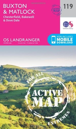
Wandelkaart 119 Buxton- Matlock & Chesterfield - OSI • 9780319474426
Wandelkaart Buxton- Matlock & Chesterfield - Derbyshire Productbeschrijving: Kaart nummer 119 in de OS Landranger kaarten serie is de ideale kaart voor het plannen van uitstapjes rond het gebied Buxton en Matlock. In het hart van het Peak District heeft dit gebied veel te bieden voor de hele familie. Wandelingen in het pittoreske platteland, spa breaks, shopping trips en de kunsten zijn hi…

Wandelkaart 259 Derby & Utoxeter- Derbyshire - OSI • 9780319244562
Wandelkaart Derby & Utoxeter - Derbyshire England Omvat ook: Uttoxeter, Ashbourne & Cheadle. 259 / Derby & Utoxeter, Derbyshire, England - Kaart nummer 259 in de OS Explorer reeks omvat Ashbourne, Uttoxeter, Cheadle en Derby in het Peak District National Park. Hoogtepunten van het gebied zijn onder andere: rivier Dove, rivier Churnet en lange afstand paden zoals Centenary way, Derwent …

Wandelkaart XT40 Pennine Way Noord - Harvey Maps • 9781851376155
Wandelkaart XT40 - Pennine Way Noord - Harvey Maps Productomschrijving: Een goede week wandelen op één kaart De Pennine Way is een wandelroute van 429km (268 mile) die van Edale in Derbyshire tot Kirk Yetholm in het Schotse grensgebied loopt. De route volgt de ruggengraat van Engeland, langs enkele van de mooiste hoge landschappen van het Peak District National Park, langs de Pennine ridge…