

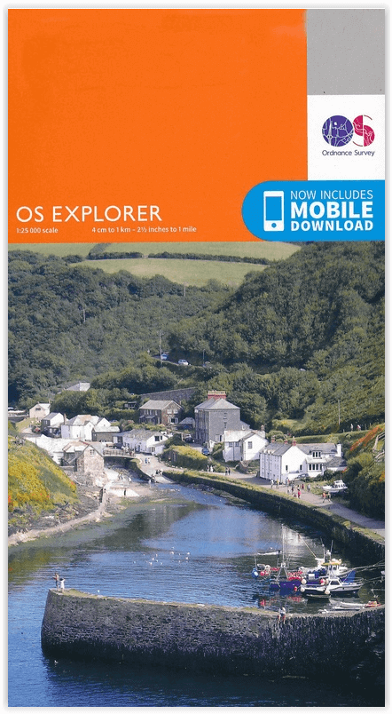
Wandelkaart 219 Wolverhampton & Dudley - OSI
Hoogtepunten zijn de Forest van Mercia & Halesowen


Korte omschrijving
Wandelkaarten West Midlands van Ordnance Survey. Ideaal voor tochten in England.
Wandelkaart Wolverhampton & Dudley - West Midlands England Omvat ook: Stourbridge & Kidderminster. Productbeschrijving: Kaart nummer 219 dekt Kidderminster, Wolverhampton, Dudley en Stou...

Specificaties
- Uitgever: Ordnance Survey
- ISBN-13: 9780319244128
- HOOFDCATEGORIEËN: Wandelkaart
- Activiteiten: Wandelen, Hiking & Trekking
- Regio: West Midlands
- Land: England
- Regionale parken: Forest of Mercia
- TOPO's & Stafkaarten: Topografisch wandelen
- Schaal: 1:25000
- Taal: Engels
- Reeks/Serie: Explorer Series OS
Volledige omschrijving
Wandelkaart Wolverhampton & Dudley - West Midlands England
Omvat ook: Stourbridge & Kidderminster.
Productbeschrijving: Kaart nummer 219 dekt Kidderminster, Wolverhampton, Dudley en Stourbridge. Hoogtepunten zijn de Forest van Mercia en de rivier Stour. Omvat ook Halesowen, Bromsgrove, Brierley Hill, Wednesbury en Bloxwich. De OS Explorer kaart voor Wolverhampton & Dudley is beschikbaar in zowel de standaard papieren versie als de weerbestendige 'Actief' versie.
Productdiscription: Map sheet number 219 covers Wolverhampton, Dudley, Stourbridge and Kidderminster. Highlights include the Forest of Mercia and River Stour. Also includes Halesowen, Bromsgrove, Brierley Hill, Wednesbury and Bloxwich. The OS Explorer map for Wolverhampton & Dudley is available in both the standard paper version and weatherproof 'Active' version.
Locatie op kaart
Gekoppelde artikelen

Wandelkaart 219 Wolverhampton & Dudley - OSI • 9780319244128
standaard versieWandelkaart Wolverhampton & Dudley - West Midlands England Omvat ook: Stourbridge & Kidderminster. Productbeschrijving: Kaart nummer 219 dekt Kidderminster, Wolverhampton, Dudley en Stourbridge. Hoogtepunten zijn de Forest van Mercia en de rivier Stour. Omvat ook Halesowen, Bromsgrove, Brierley Hill, Wednesbury en Bloxwich. De OS Explorer kaart voor Wolverhampton & Dudley is beschikbaa…

Wandelkaart 219 Wolverhampton- Dudley & Stourbridge - OSI • 9780319470916
weatherproof versieWandelkaart Wolverhampton- Dudley & Stourbridge - England Omvat ook: Stourbridge & Kidderminster. Productbeschrijving: Kaart nummer 219 dekt Kidderminster, Wolverhampton, Dudley en Stourbridge. Hoogtepunten zijn de Forest van Mercia en de rivier Stour. Omvat ook Halesowen, Bromsgrove, Brierley Hill, Wednesbury en Bloxwich. De OS Explorer kaart voor Wolverhampton & Dudley is beschikbaar…
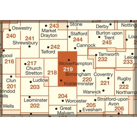
Overzichtskaarten

OSI Explorer & Explorer Active - Midden Engeland - Midlands
OSI Explorer & Explorer Active - Midden Engeland - Midlands

Producten op de overzichtskaart
Klik op een product om naar de detailpagina te gaan.
- Wandelkaart 180 Oxford- England - OSI
- Wandelkaart 181 Chiltern Hills North AONB- Wycombe - OSI
- Wandelkaart 182 St-Albans & Hatfield- Hertfordshire - OSI
- Wandelkaart 189 Hereford & Ross-on-Wye- England - OSI
- Wandelkaart 190 Malvern Hills AONB & Bredon Hill - OSI
- Wandelkaart 191 Banbury- Bicester & Chipping Norton- OSI
- Wandelkaart 192 Buckingham & Milton Keynes - OSI
- Wandelkaart 193 Luton & Stevenage- Bedfordshire - OSI
- Wandelkaart 194 Hertford & Bishop's Stortford - OSI
- Wandelkaart 202 Leominster & Bromyard Hererfordshire - OSI
- Wandelkaart 203 Ludlow & Shropshire Hills AONB - OSI
- Wandelkaart 204 Worcester & Droitwich Spa - OSI
- Wandelkaart 205 Stratford-upon-Avon & Evesham - OSI
- Wandelkaart 206 Edge Hill & Fenny Compton - OSI
- Wandelkaart 207 Newport Pagnell & Northampton - OSI
- Wandelkaart 208 Bedford & St Neots- Bedforeshire - OSI
- Wandelkaart 209 Cambridge - England - OSI
- Wandelkaart 217 Long Mynd & Wenlock Edge - OSI
- Wandelkaart 218 Kidderminster & Wyre Forest - OSI
- Wandelkaart 219 Wolverhampton & Dudley - OSI
- Wandelkaart 220 Birmingham- West Midlands - OSI
- Wandelkaart 221 Coventry & Warwickshire - OSI
- Wandelkaart 222 Rugby & Daventry- Warwickshire - OSI
- Wandelkaart 223 Northampton & Market Harborough - OSI
- Wandelkaart 224 Corby- Kettering & Wellingborough - OSI
- Wandelkaart 225 Huntingdon & St Ives - OSI
- Wandelkaart 227 Peterborough- Cambridgeshire England - OSI
- Wandelkaart 228 March- Ely- Chatteris & Littleport - OSI
- Wandelkaart 232 Nuneaton & Tamworth- Warwickshire - OSI
- Wandelkaart 233 Leicester & Hinckley England - OSI
- Wandelkaart 234 Rutland Water & Stamford- Oakham - OSI
- Wandelkaart 235 Wisbech & Peterborough North - OSI
- Wandelkaart 241 Shrewsbury- shropshire England - OSI
- Wandelkaart 242 Telford- Ironbridge & the Wrekin - OSI
- Wandelkaart 243 Market Drayton- Schropshire - OSI
- Wandelkaart 244 Cannock Chase & Chasewater- Severn - OSI
- Wandelkaart 245 National Forest- Burton-upon-Trent - OSI
- Wandelkaart 245 National Forest - OSI
- Wandelkaart 246 Loughborough- Leicestershire England - OSI
- Wandelkaart 247 Grantham- Lincolnshire - OSI
- Wandelkaart 248 Bourne & Heckington- lincolnshire - OSI
- Wandelkaart 249 Spalding & Holbeach- Lincolnshire - OSI
- Wandelkaart 257 Crewe & Nantwich & Cheshire East - OSI
- Wandelkaart 258 Stoke-on-Trent & Newcastle-under-Lyme- OSI
- Wandelkaart 259 Derby & Utoxeter- Derbyshire - OSI
- Wandelkaart 260 Nottingham & Vale of Belvoir - OSI
- Wandelkaart 261 Boston & Lincolnshire- England - OSI
- Wandelkaart 267 Northwich & Delamere Forest - OSI
- Wandelkaart 268 Wilmslow- Macclesfield & Congleton - OSI
- Wandelkaart 269 Chesterfield & Alfreton- Derbyshire- OSI
- Wandelkaart 270 Sherwood Forest- Nottinghamshire - OSI
- Wandelkaart 271 Newark-on-Trent- Nottinghampshire - OSI
- Wandelkaart 272 Lincoln- England - OSI
- Wandelkaart 273 Lincolnshire Wolds South- England - OSI
- Wandelkaart 274 Skegness- Alford & Spilsby - OSI
- Wandelkaart 275 Liverpool- South West England - OSI
- Wandelkaart 276 Bolton- Wigan & Warrington- Machester - OSI
- Wandelkaart 277 Manchester & Salford - OSI
- Wandelkaart 278 Sheffield & Barnsley- South Yorkshire - OSI
- Wandelkaart 279 Doncaster- South Yorkshire - OSI
- Wandelkaart 280 Isle of Axholme- Lincolnshire - OSI
- Wandelkaart 281 Ancholme Valley- Lincolnshire - OSI
- Wandelkaart 282 Lincolnshire Wolds North- England - OSI
- Wandelkaart 283 Louth & Mablethorpe- Lincolnshire - OSI
- Wandelkaart 284 Grimsby- Cleethorpes & Immingham - OSI
- Wandelkaart OL01 Peak District NP & Dark Peak area - OS
- Wandelkaart OL13 Brecon Beacons National Parc East - OS
- Wandelkaart OL24 Peak District & White Peak area - OS
- Wandelkaart OL40 The Broads National Park - OS
Artikelen uit dezelfde regio

Wandelkaart 139 Birmingham & Wolverhampton - OSI • 9780319474624
Wandelkaart Birmingham & Wolverhampton - West Midlands Productbeschrijving: Het centrum van OS Landranger kaart 139, Birmingham, is een levendige en gekweekte stad met Wolverhampton net naast de deur en het zwarte land, beroemd om haar midden van de negentiende eeuwse smederijen. De OS Landranger kaarten reeks heeft betrekking op Groot-Brittannië met 204 gedetailleerde kaarten, perfect voo…

Wandelgids Offa's Dyke path - Prestatyn to Chepstow - Trailblazer • 9781912716425
Wandelgids Offa's Dyke path, Prestatyn to Chepstow - Trailblazer Productomschrijving: (British Walking Guide) The Offa's Dyke Path is a superb National Trail that runs from the North Wales coast to the Severn Estuary following the line of Offa's Dyke (283 km), an impressive 8th-century earthwork along the English/Welsh border. The ever-changing landscape – the Clwydian Range, the Shropshi…

Wandelkaart 221 Coventry & Warwick- West Midlands - OSI • 9780319470930
Wandelkaart Coventry & Warwick - West Midlands England Productbeschrijving: OS Explorer kaart 221 omvat Coventry, Warwick, Royal Leamington Spa en de omliggende gebieden. Ontdek Warwick Castle, en zet vervolgens uw avontuur door langs de rivier de Avon, of bezoek het Fort Lunt Roamn in de buurt van Coventry. De OS Explorer kaart voor Coventry & Warwick is beschikbaar in zowel de standaard …

Wandelkaart 258 Stoke-on-Trent & Newcastle-under-Lyme- OSI • 9780319471302
Wandelkaart Stoke-on-Trent & Newcastle-under-Lyme - England Omvat ook: Biddulph & Stone. Productbeschrijving: Van Biddulph in het noorden tot Stone in het zuiden tot de bestrating van Stoke-on-Trent en Newcastle-under-Lyme, zal OS Explorer kaart blad 258 zal u helpen bij het verkennen van deze industriële landschappen. De OS Explorer kaart voor Stoke-on-Trent & Newcastle-under-Lyme is …

Wandelkaart 220 Birmingham Walsall & Solihull - OSI • 9780319470923
Wandelkaart Birmingham- Walsall- Solihull & Redditch - England Omvat ook: Walsall, Solihull & Redditch. Productbeschrijving: Kaart nummer 220 in de OS Explorer reeks beslaat het gebied in de Midlands rond Birmingham en Solihull. Hij omvat de omgeving van Walsall en het bos van Mercia in het noorden van de kaart, naar Redditch in het zuiden. Hier lopen de paden van de Beacon Way, de Gra…