

Wandelkaart 99 Northallerton & Ripon- N. Yorkshire - OSI
De Yorkshire Dales en de North York Moors


Korte omschrijving
Wandelkaarten North Yorkshire, Engeland van Ordnance Survey. Ideaal voor tochten in United Kingdom, Great Britain en England.
Wandelkaart Northallerton & Ripon - North Yorkshire England Productbeschrijving: Ligt tussen de Yorkshire Dales en de North York Moors, het gebied gedekt door OS Landranger kaart 99 wordt v...

Specificaties
- Uitgever: Ordnance Survey
- ISBN-13: 9780319474228
- HOOFDCATEGORIEËN: Wandelkaart
- Activiteiten: Wandelen, Hiking & Trekking
- Regio: North Yorkshire, Engeland
- Land: England, United Kingdom, Great Britain
- Waterafstotende kaart: Ordnance Survey ACTIVE Landranger Weatherproof Maps
- TOPO's & Stafkaarten: Topografisch wandelen
- Schaal: 1:50000
- Taal: Engels
- Reeks/Serie: Landranger ACTIVE series OSI
- De Engelse Graafschappen: North Yorkshire, Yorkshire
Volledige omschrijving
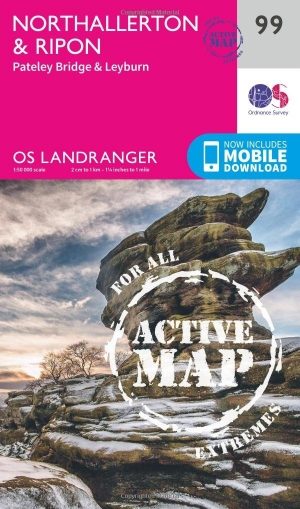
Wandelkaart Northallerton & Ripon - North Yorkshire England
Productbeschrijving: Ligt tussen de Yorkshire Dales en de North York Moors, het gebied gedekt door OS Landranger kaart 99 wordt vaak vergeten, maar omvat wel de oude kathedraal stad van Ripon, Northallerton en andere kleinere steden. De OS Landranger kaarten reeks heeft betrekking op Groot-Brittannië met 204 gedetailleerde kaarten, perfect voor dagtochten en korte pauzes. Elke kaart bevat alle informatie die u nodig heeft om dit lokaal gebied te leren kennen en omvat plaatsen van belang, toeristische informatie, picknickplaatsen en campings, plus doorgangsrechten informatie voor Engeland en Wales.
Productdiscription: Set between the Yorkshire Dales and North York Moors, the area covered by OS Landranger map 99 is often overlooked, but includes the ancient cathedral city of Ripon, Northallerton and other smaller towns. The OS Landranger Map series covers Great Britain with 204 detailed maps, perfect for day trips and short breaks. Each map provides all the information you need to get to know your local area and includes places of interest, tourist information, picnic areas and camp sites, plus Rights of Way information for England and Wales.
Locatie op kaart
Gekoppelde artikelen

Wandelkaart 99 Northallerton & Ripon- N. Yorkshire - OSI • 9780319261972
standaard versieWandelkaart Northallerton & Ripon - North Yorkshire England Productbeschrijving: Ligt tussen de Yorkshire Dales en de North York Moors, het gebied gedekt door OS Landranger kaart 99 wordt vaak vergeten, maar omvat de oude kathedraal stad van Ripon, Northallerton en andere kleinere steden. De OS Landranger kaarten reeks heeft betrekking op Groot-Brittannië met 204 gedetailleerde kaarten…
Wandelkaart 99 Northallerton & Ripon- N. Yorkshire - OSI • 9780319474228
weatherproof versieWandelkaart Northallerton & Ripon - North Yorkshire England Productbeschrijving: Ligt tussen de Yorkshire Dales en de North York Moors, het gebied gedekt door OS Landranger kaart 99 wordt vaak vergeten, maar omvat wel de oude kathedraal stad van Ripon, Northallerton en andere kleinere steden. De OS Landranger kaarten reeks heeft betrekking op Groot-Brittannië met 204 gedetailleerde kaarte…
Overzichtskaarten
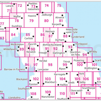
OSI Landranger & Landranger Active - Noord Engeland - Lake District
OSI Landranger & Landranger Active - Noord Engeland - Lake District
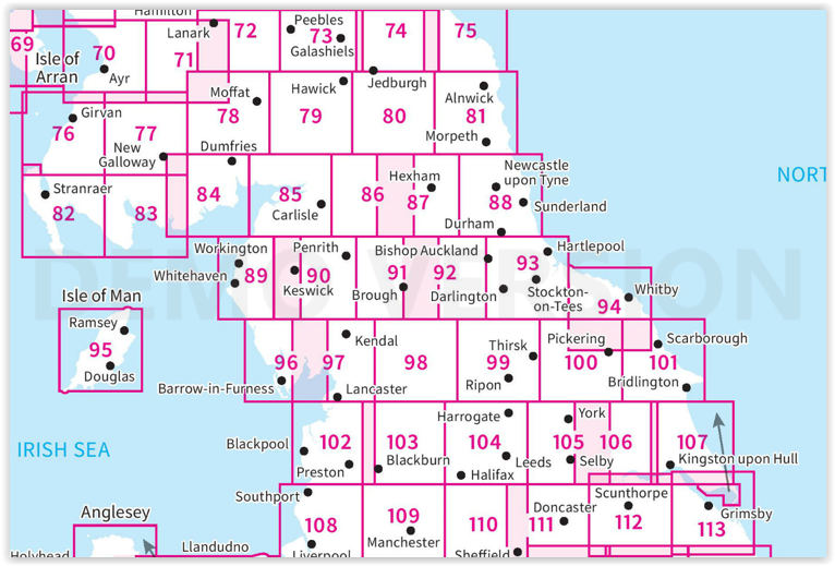
Producten op de overzichtskaart
Klik op een product om naar de detailpagina te gaan.
- Wandelkaart 70 Ayr- Kilmarnock & Troon- Schotland - OSI
- Wandelkaart 70 Ayr- Kilmarnock & Troon- Schotland - OSI
- Wandelkaart 71 Lanark & Upper Nithsdale- Schotland - OSI
- Wandelkaart 71 Lanark & Upper Nithsdale- S. Lanarkshire - OSI
- Wandelkaart 72 Upper Clyde Valley- Lanarkshire - OSI
- Wandelkaart 72 Upper Clyde Valley- Lanarkshire - OSI
- Wandelkaart 73 Peebles- Galashiels & Selkirk - Schotland - OSI
- Wandelkaart 73 Peebles- Galashiels & Selkirk - Schotland - OSI
- Wandelkaart 74 Kelso & Coldstream - Schotland - OSI
- Wandelkaart 74 Kelso & Coldstream - Schotland - OSI
- Wandelkaart 75 Berwick-upon-Tweed- England - OSI
- Wandelkaart 75 Berwick-upon-Tweed- Northumberland - OSI
- Wandelkaart 76 Girvan- South Ayrshire- Schotland - OSI
- Wandelkaart 76 Girvan- South Ayrshire-Schotland - OSI
- Wandelkaart 77 Dalmellington & New Galloway- Schotland - OSI
- Wandelkaart 77 Dalmellington & New Galloway- Schotland - OSI
- Wandelkaart 78 Nithsdale & Annandale- Schotland - OSI
- Wandelkaart 78 Nithsdale & Annandale- Schotland - OSI
- Wandelkaart 79 Hawick & Eskdale - Schotland - OSI
- Wandelkaart 79 Hawick & Eskdale- Schotland - OSI
- Wandelkaart 80 Cheviot Hills & Kielder Water- England - OSI
- Wandelkaart 80 Cheviot Hills & Kielder Water- England - OSI
- Wandelkaart 81 Alnwick & Morpeth - Northumberland - OSI
- Wandelkaart 82 Stranraer & Glenluce - Schotland - OSI
- Wandelkaart 82 Stranraer & Glenluce - Schotland - OSI
- Wandelkaart 83 Newton Stewart & Kirkcudbright- Schotland - OSI
- Wandelkaart 83 Newton Stewart & Kirkcudbright- Schotland - OSI
- Wandelkaart 84 Dumfries & Castle Douglas- Schotland - OSI
- Wandelkaart 84 Dumfries & Castle Douglas- Schotland - OSI
- Wandelkaart 85 Carlisle & Solway Firth- Cumbria England - OSI
- Wandelkaart 85 Carlisle & Solway Firth- Cumbria England - OSI
- Wandelkaart 86 Haltwhistle & Brampton - OSI
- Wandelkaart 86 Haltwhistle & Brampton - OSI
- Wandelkaart 87 Hexham & Haltwhistle- England - OSI
- Wandelkaart 87 Hexham & Haltwhistle- England - OSI
- Wandelkaart 88 Newcastle upon Tyne- N.E. England - OSI
- Wandelkaart 88 Newcastle upon Tyne- N.E. England - OSI
- Wandelkaart 89 West Cumbria England - OSI
- Wandelkaart 89 West Cumbria England - OSI
- Wandelkaart 90 Penrith & Keswick - Lake District NP - OSI
- Wandelkaart 90 Lake Distrist NP - Penrith & Keswick - OSI
- Wandelkaart 91 Appleby-in-Westmorland - OSI
- Wandelkaart 91 Appleby-in-Westmorland - OSI
- Wandelkaart 92 Barnard Castle Teesdale - England - OSI
- Wandelkaart 92 Barnard Castle Teesdale - England - OSI
- Wandelkaart 93 Middlesbrough & Darlington- England - OSI
- Wandelkaart 93 Middlesbrough & Darlington- England - OSI
- Wandelkaart 94 Whitby & Esk Dale- North Yorkshire - OSI
- Wandelkaart 94 Whitby & Esk Dale- North Yorkshire - OSI
- Wandelkaart 95 Isle of Man- England - OSI
- Wandelkaart 95 Isle of Man- England - OSI
- Wandelkaart 96 Barrow-in-Furness & South Lakeland - OSI
- Wandelkaart 96 Barrow-in-Furness & South Lakeland - OSI
- Wandelkaart 97 Kendal & Morecambe- Cumbria - OSI
- Wandelkaart 97 Kendal & Morecambe- Cumbria - OSI
- Wandelkaart 99 Northallerton & Ripon- N. Yorkshire - OSI
- Wandelkaart 99 Northallerton & Ripon- N. Yorkshire - OSI
- Wandelkaart 100 Malton & Pickering- Yorkshire - OSI
- Wandelkaart 100 Malton & Pickering- Yorkshire - OSI
- Wandelkaart 101 Scarborough- Bridlington & Filey - OSI
- Wandelkaart 101 Scarborough- North Yorkshire - OSI
- Wandelkaart 102 Preston & Blackpool- Lancashire - OSI
- Wandelkaart 102 Preston & Blackpool- Lytham - OSI
- Wandelkaart 103 Blackburn & Burnley- N.W. England - OSI
- Wandelkaart 103 Blackburn- Burnley & Clitheroe - OSI
- Wandelkaart 104 Leeds & Bradford - West Yorkshire - OSI
- Wandelkaart 104 Leeds & Bradford & Harrogate - OSI
- Wandelkaart 105 York & Selby- North Yorkshire - OSI
- Wandelkaart 105 York & Selby- North Yorkshire - OSI
- Wandelkaart 106 Market Weighton- East Riding of Yorkshire - OSI
- Wandelkaart 106 Market Weighton- Goole- England - OSI
- Wandelkaart 107 Kingston upon Hull- Beverley - OSI
- Wandelkaart 107 Kingston upon Hull- Yorkshire - OSI
- Wandelkaart 108 Liverpool & Southport - England - OSI
- Wandelkaart 108 Liverpool- Merseyside England - OSI
- Wandelkaart 109 Greater Manchester England - OSI
- Wandelkaart 109 Manchester- Bolton & Warrington - OSI
- Wandelkaart 110 Sheffield & Huddersfield - Glossop - OSI
- Wandelkaart 110 Sheffield & Huddersfield - Yorkshire - OSI
- Wandelkaart 111 Sheffield & Doncaster England - OSI
- Wandelkaart 111 Sheffield & Doncaster- Rotherham - OSI
- Wandelkaart 112 Scunthorpe & Gainsborough - OSI
- Wandelkaart 112 Scunthorpe & Gainsborough - OSI
- Wandelkaart 113 Grimsby- Louth & Market Rasen - OSI
- Wandelkaart 113 Grimsby- North East Lincolnshire - OSI
Artikelen uit dezelfde regio

Wandelkaart Fietskaart Forest of Bowland - Harvey maps • 9781851374731
Wandelkaart - Fietskaart Forest of Bowland - Harvey maps Productomschrijving: Deze kaart van de Forest of Bowland is 2-in-1. Aan de ene kant is een wandelkaart; aan de andere een kaart geschikt voor fietsers. De Forest of Bowland heeft veel te bieden voor wandelaars, ruiters en fietsers, en deze praktische kaart zal u helpen om dit prachtige deel van Engeland te verkennen. De wandelaar…

Wandelkaart 297 Lower Wharefedale & Washburn Valley- OSI • 9780319471692
Wandelkaart Lower Wharefedale & Washburn Valley - North Yorkshire Omvat ook: Harrogate & Ilkley Moor. Productbeschrijving: Kaart nummer 297 in de OS Explorer reeks heeft betrekking op het Nidderdale gebied van buitengewone natuurlijke schoonheid AONB en het Yorkshire Dales National Park. De stad van Harrogate is omgeven door het Harrogate Ringway recreatieve pad, terwijl de Dales Way l…
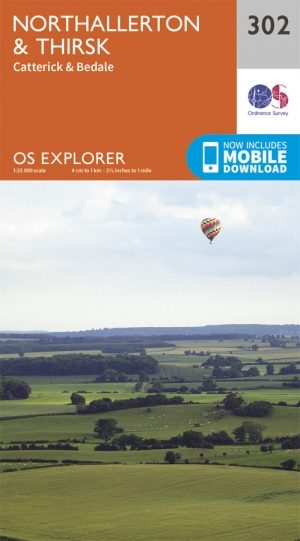
Wandelkaart 302 Northallerton & Thirsk- North Yorkshire • 9780319245545
Wandelkaart Northallerton & Thirsk - North Yorkshire England Omvat ook: Catterick & Bedale Productomschrijving: Kaart nummer 302 in de OS Explorer kaarten reeks is ideaal voor het ontdekken North Yorkshire rond Thirsk en Northallerton. Dit gebied maakt deel uit van de Vale van Mowbray, en heeft meanderende rivieren en golvende landschappen te verkennen, die in detail op deze kaart word…

Wandelkaart OL41 - Forest of Bowland & Ribblesdale - OSI • 9780319469590
Wandelkaart Forest of Bowland & Ribblesdale - North Yorkshire Omvat ook: Pendle Hill, Clitheroe & Settle Productbeschrijving: Kaart nummer OL41 in de OS Explorer kaarten reeks omvat de Forest of Bowland en Yorkshire Dales National Park in de buurt van Clitheroe. Hoogtepunten van het gebied zijn onder andere: Ribble way & Wyre way, Lune Valley walkway en Pendle way, samen met de steden …

Wandelgids 093 Pathfinde North Yorkshire Accessible walks - OS • 9780319092859
Wandelgids North Yorkshire Accessible walks - OS Productomschrijving: This guide comprises 33 beautiful walks, ranging in distance from 0.5 to 8 miles, across North Yorkshire, with ten routes in the Yorkshire Dales National Park, eleven in the North York Moors National Park, North Sea coast routes at Whitby, Robin Hood’s Bay and Bempton, and routes handily placed near the Richmond, Ripon, …