

Wandelkaart 75 Berwick-upon-Tweed- England - OSI
Berwick-upon-Tweed- de meest noordelijke stad in Engeland

Korte omschrijving
Wandelkaarten Engeland en Northhumberland, Engeland van Ordnance Survey. Ideaal voor tochten in England.
Wandelkaart Berwick-upon-Tweed - Northumebrland England Productbeschrijving: Gelegen dichtbij de Schotse grens, is Berwick-upon-Tweed de meest noordelijke stad in Engeland, en verschijnt op ...

Specificaties
- Uitgever: Ordnance Survey
- ISBN-13: 9780319261736
- HOOFDCATEGORIEËN: Wandelkaart
- Activiteiten: Wandelen, Hiking & Trekking
- Regio: Engeland, Northhumberland, Engeland
- Land: England
- TOPO's & Stafkaarten: Topografisch wandelen
- Schaal: 1:50000
- Taal: Engels
- Reeks/Serie: Landranger Series OSI
Volledige omschrijving
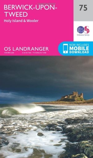
Wandelkaart Berwick-upon-Tweed - Northumebrland England
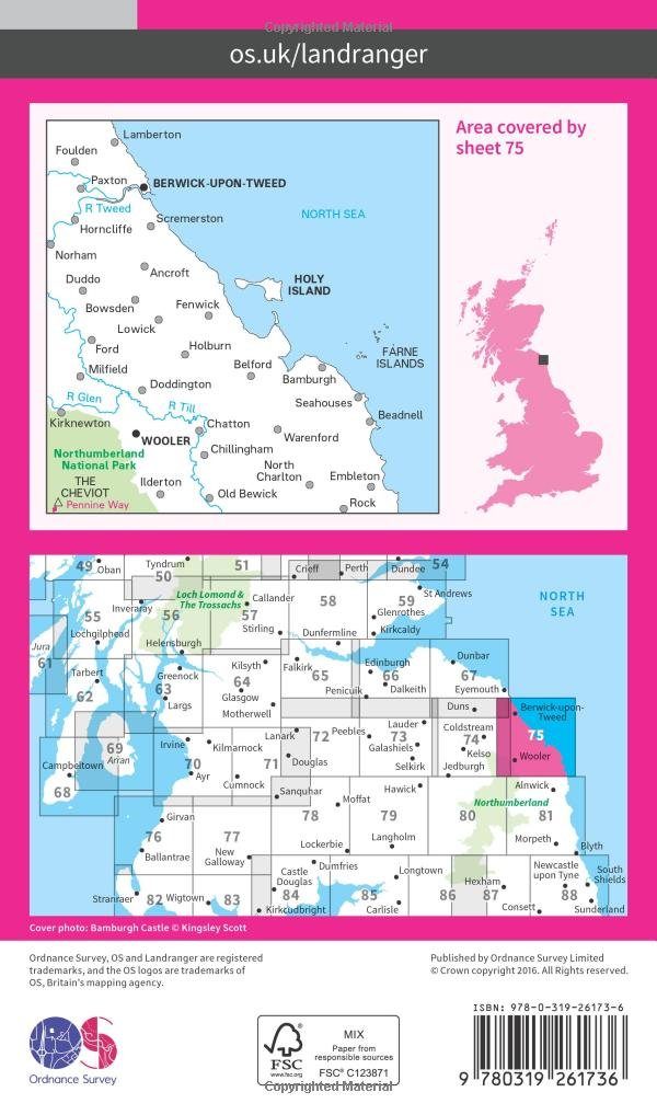
Productbeschrijving: Gelegen dichtbij de Schotse grens, is Berwick-upon-Tweed de meest noordelijke stad in Engeland, en verschijnt op kaart nummer 75 in de OS Landranger kaarten reeks. Vele bezienswaardigheden te ontdekken in de omgeving. De enorme uitgestrektheid van Northumberland platteland beschikt over glooiende heuvels, stranden, historische monumenten en interessante musea.
De OS Landranger kaarten reeks heeft betrekking op Groot-Brittannië met 204 gedetailleerde kaarten, perfect voor dagtochten en korte pauzes. Elke kaart bevat alle informatie die u nodig heeft om dit lokaal gebied te leren kennen en omvat plaatsen van belang, toeristische informatie, picknickplaatsen en campings, plus doorgangsrechten informatie voor Engeland en Wales.
Productdiscription: Located close to the Scottish border, Berwick-upon-Tweed is the northern-most town in England, and appears in map sheet number 75 in the OS Landranger map. There is a magnitude of activities and attractions to discover in the local area. The vast expanse of surrounding Northumberland countryside features rolling hills, beaches, historical landmarks and interesting museums.
The OS Landranger Map series covers Great Britain with 204 detailed maps, perfect for day trips and short breaks. Each map provides all the information you need to get to know your local area and includes places of interest, tourist information, picnic areas and camp sites, plus Rights of Way information for England and Wales.
Locatie op kaart
Gekoppelde artikelen
Wandelkaart 75 Berwick-upon-Tweed- England - OSI • 9780319261736
standaard versieWandelkaart Berwick-upon-Tweed - Northumebrland England Productbeschrijving: Gelegen dichtbij de Schotse grens, is Berwick-upon-Tweed de meest noordelijke stad in Engeland, en verschijnt op kaart nummer 75 in de OS Landranger kaarten reeks. Vele bezienswaardigheden te ontdekken in de omgeving. De enorme uitgestrektheid van Northumberland platteland beschikt over glooiende heuvels, stranden…
Wandelkaart 75 Berwick-upon-Tweed - OSI • 9780319473986
weatherproof versieWandelkaart Berwick-upon-Tweed - Northumberland England Productbeschrijving: Gelegen dichtbij de Schotse grens, is Berwick-upon-Tweed de meest noordelijke stad in Engeland, en verschijnt op deze kaart met nummer 75 in de OS Landranger-kaarten reeks. Er is een magnitude aan activiteiten en bezienswaardigheden te ontdekken in de omgeving. De enorme uitgestrektheid van Northumberland plattela…
Overzichtskaarten
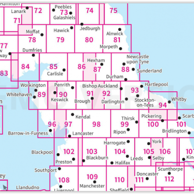
OSI Landranger & Landranger Active - Noord Engeland - Lake District
OSI Landranger & Landranger Active - Noord Engeland - Lake District
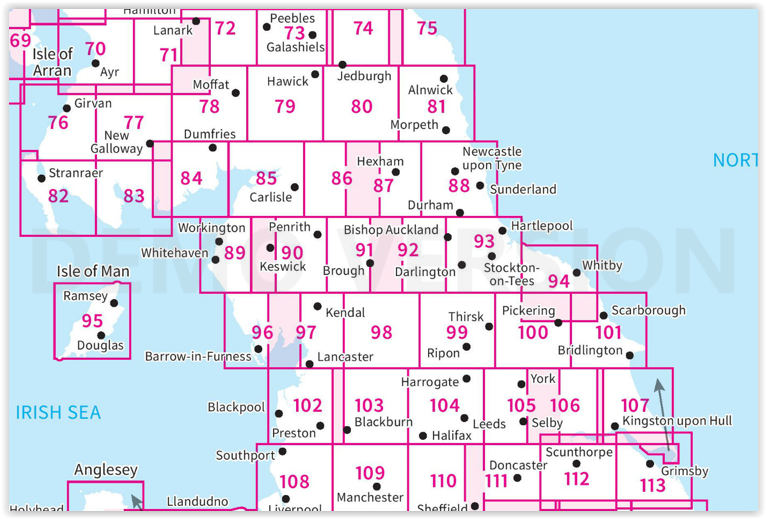
Producten op de overzichtskaart
Klik op een product om naar de detailpagina te gaan.
- Wandelkaart 70 Ayr- Kilmarnock & Troon- Schotland - OSI
- Wandelkaart 70 Ayr- Kilmarnock & Troon- Schotland - OSI
- Wandelkaart 71 Lanark & Upper Nithsdale- Schotland - OSI
- Wandelkaart 71 Lanark & Upper Nithsdale- S. Lanarkshire - OSI
- Wandelkaart 72 Upper Clyde Valley- Lanarkshire - OSI
- Wandelkaart 72 Upper Clyde Valley- Lanarkshire - OSI
- Wandelkaart 73 Peebles- Galashiels & Selkirk - Schotland - OSI
- Wandelkaart 73 Peebles- Galashiels & Selkirk - Schotland - OSI
- Wandelkaart 74 Kelso & Coldstream - Schotland - OSI
- Wandelkaart 74 Kelso & Coldstream - Schotland - OSI
- Wandelkaart 75 Berwick-upon-Tweed- England - OSI
- Wandelkaart 75 Berwick-upon-Tweed- Northumberland - OSI
- Wandelkaart 76 Girvan- South Ayrshire- Schotland - OSI
- Wandelkaart 76 Girvan- South Ayrshire-Schotland - OSI
- Wandelkaart 77 Dalmellington & New Galloway- Schotland - OSI
- Wandelkaart 77 Dalmellington & New Galloway- Schotland - OSI
- Wandelkaart 78 Nithsdale & Annandale- Schotland - OSI
- Wandelkaart 78 Nithsdale & Annandale- Schotland - OSI
- Wandelkaart 79 Hawick & Eskdale - Schotland - OSI
- Wandelkaart 79 Hawick & Eskdale- Schotland - OSI
- Wandelkaart 80 Cheviot Hills & Kielder Water- England - OSI
- Wandelkaart 80 Cheviot Hills & Kielder Water- England - OSI
- Wandelkaart 81 Alnwick & Morpeth - Northumberland - OSI
- Wandelkaart 82 Stranraer & Glenluce - Schotland - OSI
- Wandelkaart 82 Stranraer & Glenluce - Schotland - OSI
- Wandelkaart 83 Newton Stewart & Kirkcudbright- Schotland - OSI
- Wandelkaart 83 Newton Stewart & Kirkcudbright- Schotland - OSI
- Wandelkaart 84 Dumfries & Castle Douglas- Schotland - OSI
- Wandelkaart 84 Dumfries & Castle Douglas- Schotland - OSI
- Wandelkaart 85 Carlisle & Solway Firth- Cumbria England - OSI
- Wandelkaart 85 Carlisle & Solway Firth- Cumbria England - OSI
- Wandelkaart 86 Haltwhistle & Brampton - OSI
- Wandelkaart 86 Haltwhistle & Brampton - OSI
- Wandelkaart 87 Hexham & Haltwhistle- England - OSI
- Wandelkaart 87 Hexham & Haltwhistle- England - OSI
- Wandelkaart 88 Newcastle upon Tyne- N.E. England - OSI
- Wandelkaart 88 Newcastle upon Tyne- N.E. England - OSI
- Wandelkaart 89 West Cumbria England - OSI
- Wandelkaart 89 West Cumbria England - OSI
- Wandelkaart 90 Penrith & Keswick - Lake District NP - OSI
- Wandelkaart 90 Lake Distrist NP - Penrith & Keswick - OSI
- Wandelkaart 91 Appleby-in-Westmorland - OSI
- Wandelkaart 91 Appleby-in-Westmorland - OSI
- Wandelkaart 92 Barnard Castle Teesdale - England - OSI
- Wandelkaart 92 Barnard Castle Teesdale - England - OSI
- Wandelkaart 93 Middlesbrough & Darlington- England - OSI
- Wandelkaart 93 Middlesbrough & Darlington- England - OSI
- Wandelkaart 94 Whitby & Esk Dale- North Yorkshire - OSI
- Wandelkaart 94 Whitby & Esk Dale- North Yorkshire - OSI
- Wandelkaart 95 Isle of Man- England - OSI
- Wandelkaart 95 Isle of Man- England - OSI
- Wandelkaart 96 Barrow-in-Furness & South Lakeland - OSI
- Wandelkaart 96 Barrow-in-Furness & South Lakeland - OSI
- Wandelkaart 97 Kendal & Morecambe- Cumbria - OSI
- Wandelkaart 97 Kendal & Morecambe- Cumbria - OSI
- Wandelkaart 99 Northallerton & Ripon- N. Yorkshire - OSI
- Wandelkaart 99 Northallerton & Ripon- N. Yorkshire - OSI
- Wandelkaart 100 Malton & Pickering- Yorkshire - OSI
- Wandelkaart 100 Malton & Pickering- Yorkshire - OSI
- Wandelkaart 101 Scarborough- Bridlington & Filey - OSI
- Wandelkaart 101 Scarborough- North Yorkshire - OSI
- Wandelkaart 102 Preston & Blackpool- Lancashire - OSI
- Wandelkaart 102 Preston & Blackpool- Lytham - OSI
- Wandelkaart 103 Blackburn & Burnley- N.W. England - OSI
- Wandelkaart 103 Blackburn- Burnley & Clitheroe - OSI
- Wandelkaart 104 Leeds & Bradford - West Yorkshire - OSI
- Wandelkaart 104 Leeds & Bradford & Harrogate - OSI
- Wandelkaart 105 York & Selby- North Yorkshire - OSI
- Wandelkaart 105 York & Selby- North Yorkshire - OSI
- Wandelkaart 106 Market Weighton- East Riding of Yorkshire - OSI
- Wandelkaart 106 Market Weighton- Goole- England - OSI
- Wandelkaart 107 Kingston upon Hull- Beverley - OSI
- Wandelkaart 107 Kingston upon Hull- Yorkshire - OSI
- Wandelkaart 108 Liverpool & Southport - England - OSI
- Wandelkaart 108 Liverpool- Merseyside England - OSI
- Wandelkaart 109 Greater Manchester England - OSI
- Wandelkaart 109 Manchester- Bolton & Warrington - OSI
- Wandelkaart 110 Sheffield & Huddersfield - Glossop - OSI
- Wandelkaart 110 Sheffield & Huddersfield - Yorkshire - OSI
- Wandelkaart 111 Sheffield & Doncaster England - OSI
- Wandelkaart 111 Sheffield & Doncaster- Rotherham - OSI
- Wandelkaart 112 Scunthorpe & Gainsborough - OSI
- Wandelkaart 112 Scunthorpe & Gainsborough - OSI
- Wandelkaart 113 Grimsby- Louth & Market Rasen - OSI
- Wandelkaart 113 Grimsby- North East Lincolnshire - OSI
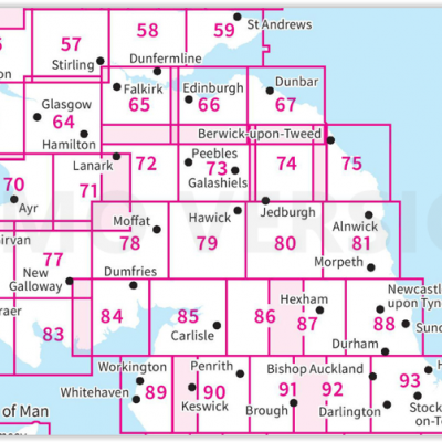
OSI Landranger & Landranger Active - Zuid Schotland & Scotisch Borders
OSI Landranger & Landranger Active - Zuid Schotland & Scotisch Borders
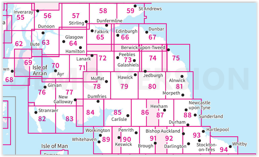
Producten op de overzichtskaart
Klik op een product om naar de detailpagina te gaan.
- Wandelkaart 55 Lochgilphead & Loch Awe - OSI
- Wandelkaart 55 Lochgilphead & Loch Awe - OSI
- Wandelkaart 56 Loch Lomond & Inveraray- Trossachs NP - OSI
- Wandelkaart 56 Loch Lomond & Inveraray- Trossachs NP - OSI
- Wandelkaart 57 Stirling & The Trossachs NP - Highland's - OSI
- Wandelkaart 57 Stirling & The Trossachs NP - Schotland - OSI
- Wandelkaart 58 Perth & Alloa - Perth & Kinross - OSI
- Wandelkaart 58 Perth & Alloa - perth & Kinross - OSI
- Wandelkaart 59 St-Andrews- Fife Schotland - OSI
- Wandelkaart 59 St-Andrews- Fife- Schotland - OSI
- Wandelkaart 62 North Kintyre & Tarbert - Schotland - OSI
- Wandelkaart 62 North Kintyre & Tarbert - Schotland - OSI
- Wandelkaart 63 Firth of Clyde- Argyl & Bute - Schotland - OSI
- Wandelkaart 63 Firth of Clyde- Argyl & Bute - Schotland - OSI
- Wandelkaart 64 Glasgow City Schotland - OSI
- Wandelkaart 64 Glasgow City Schotland- OSI
- Wandelkaart 65 Falkirk & Linlithgow - Edinburgh - OSI
- Wandelkaart 65 Falkirk & Linlithgow - West Schotland - OSI
- Wandelkaart 66 Edinburgh - Western Schotland - OSI
- Wandelkaart 66 Edinburgh - Western Schotland - OSI
- Wandelkaart 67 Duns- Dunbar & Eyemouth- Schotland - OSI
- Wandelkaart 67 Duns- Dunbar & Eyemouth- Schotland - OSI
- Wandelkaart 68 South Kintyre & Campbeltown - OSI
- Wandelkaart 68 South Kintyre & Campbeltown - OSI
- Wandelkaart 69 Isle of Arran - Inner Hybrids - OSI
- Wandelkaart 69 Isle of Arran - Inner Hybrids - OSI
- Wandelkaart 70 Ayr- Kilmarnock & Troon- Schotland - OSI
- Wandelkaart 70 Ayr- Kilmarnock & Troon- Schotland - OSI
- Wandelkaart 71 Lanark & Upper Nithsdale - OSI
- Wandelkaart 71 Lanark & Upper Nithsdale - OSI
- Wandelkaart 72 Upper Clyde Valley- Lanarkshire - OSI
- Wandelkaart 72 Upper Clyde Valley- Lanarkshire - OSI
- Wandelkaart 73 Peebles- Galashiels & Selkirk - Schotland - OSI
- Wandelkaart 73 Peebles- Galashiels & Selkirk - Schotland - OSI
- Wandelkaart 74 Kelso & Coldstream - Schotland - OSI
- Wandelkaart 74 Kelso & Coldstream - Schotland - OSI
- Wandelkaart 75 Berwick-upon-Tweed- England - OSI
- Wandelkaart 75 Berwick-upon-Tweed - OSI
- Wandelkaart 76 Girvan- South Ayrshire - Schotland - OSI
- Wandelkaart 76 Girvan- South Ayrshire -Schotland - OSI
- Wandelkaart 77 Dalmellington & New Galloway- Schotland - OSI
- Wandelkaart 77 Dalmellington & New Galloway- Schotland - OSI
- Wandelkaart 78 Nithsdale & Annandale- Schotland - OSI
- Wandelkaart 78 Nithsdale & Annandale- Schotland - OSI
- Wandelkaart 79 Hawick & Eskdale - Schotland - OSI
- Wandelkaart 79 Hawick & Eskdale - Schotland - OSI
- Wandelkaart 80 Cheviot Hills & Kielder Water - England - OSI
- Wandelkaart 80 Cheviot Hills & Kielder Water - England - OSI
- Wandelkaart 81 Alnwick & Morpeth - Northumberland - OSI
- Wandelkaart 82 Stranraer & Glenluce - Schotland - OSI
- Wandelkaart 82 Stranraer & Glenluce - Schotland - OSI
- Wandelkaart 83 Newton Stewart & Kirkcudbright- Schotland - OSI
- Wandelkaart 83 Newton Stewart & Kirkcudbright- Schotland - OSI
- Wandelkaart 84 Dumfries & Castle Douglas- Schotland - OSI
- Wandelkaart 84 Dumfries & Castle Douglas- Schotland - OSI
- Wandelkaart 85 Carlisle & Solway Firth- Cumbria England - OSI
- Wandelkaart 85 Carlisle & Solway Firth- Cumbria England - OSI
- Wandelkaart 86 Haltwhistle & Brampton - OSI
- Wandelkaart 86 Haltwhistle & Brampton - OSI
- Wandelkaart 87 Hexham & Haltwhistle- England - OSI
- Wandelkaart 87 Hexham & Haltwhistle- England - OSI
- Wandelkaart 88 Newcastle upon Tyne- N.E. England - OSI
- Wandelkaart 88 Newcastle upon Tyne- N.E. England - OSI
- Wandelkaart 89 West Cumbria England - OSI
- Wandelkaart 89 West Cumbria England - OSI
- Wandelkaart 91 Appleby-in-Westmorland - OSI
- Wandelkaart 91 Appleby-in-Westmorland - OSI
- Wandelkaart 92 Barnard Castle Teesdale - England - OSI
- Wandelkaart 92 Barnard Castle Teesdale - England - OSI
- Wandelkaart 93 Middlesbrough & Darlington- England - OSI
- Wandelkaart 93 Middlesbrough & Darlington- England - OSI
- Wandelkaart 94 Whitby & Esk Dale- North Yorkshire - OSI
- Wandelkaart 94 Whitby & Esk Dale- North Yorkshire - OSI
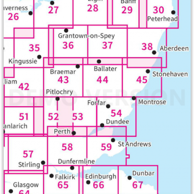
OSI Landranger & Landranger Active - Noord Oost Schotland - Cairngorms
OSI Landranger & Landranger Active - Noord Oost Schotland - Cairngorms

Producten op de overzichtskaart
Klik op een product om naar de detailpagina te gaan.
- Wandelkaart 21 Dornoch & Alness- Highland's - Schotland - OSI
- Wandelkaart 21 Dornoch & Alness- Highland's - Schotland - OSI
- Wandelkaart 26 Inverness & Loch Ness- Schotland - OSI
- Wandelkaart 26 Inverness & Loch Ness- Schotland - OSI
- Wandelkaart 27 Nairn & Forres- Highland's Schotland - OSI
- Wandelkaart 27 Nairn & Forres- Highland's Schotland - OSI
- Wandelkaart 28 Elgin & Dufftown & Moray - Schotland- OSI
- Wandelkaart 28 Elgin & Dufftown- Moray - Schotland - OSI
- Wandelkaart 29 Banff & Huntly - Schotland - OSI
- Wandelkaart 29 Banff & Huntly - Schotland - OSI
- Wandelkaart 30 Fraserburgh- Aberdeenshire Schotland - OSI
- Wandelkaart 30 Fraserburgh- Aberdeenshire Schotland - OSI
- Wandelkaart 35 Kingussie & Cairngorms NP - Highland's - OSI
- Wandelkaart 35 Kingussie & Cairngorms NP - Highland's - OSI
- Wandelkaart 36 Grantown & Aviemore - Cairngorms NP - OSI
- Wandelkaart 36 Grantown & Aviemore - Cairngorms - OSI
- Wandelkaart 37 Strathdon & Alford - Schotland - OSI
- Wandelkaart 37 Strathdon & Alford - Schotland - OSI
- Wandelkaart 38 Aberdeen- Schotland - OSI
- Wandelkaart 38 Aberdeen- Schotland - OSI
- Wandelkaart 42 Glen Garry & Loch Rannoch - OSI
- Wandelkaart 42 Glen Garry & Loch Rannoch - OSI
- Wandelkaart 43 Braemar & Blair Athol - Perth & Kinross - OSI
- Wandelkaart 43 Braemar & Blair Athol - Perth & Kinross - OSI
- Wandelkaart 44 Ballater & Glen Clova - Aberdeenshire - OSI
- Wandelkaart 44 Ballater & Glen Clova - Aberdeenshire - OSI
- Wandelkaart 45 Stonehaven & Banchory - OSI
- Wandelkaart 45 Stonehaven - Banchory - OSI
- Wandelkaart 51 Loch Tay & Glen Dochart- Highland's - OSI
- Wandelkaart 51 Loch Tay & Glen Dochart- Highland's - OSI
- Wandelkaart 52 Pitlochry & Crieff- Perth & Kinross - OSI
- Wandelkaart 52 Pitlochry & Crieff- Perth & Kinross - OSI
- Wandelkaart 53 Blairgowrie & Forest of Alyth- Schotland - OSI
- Wandelkaart 53 Blairgowrie & Forest of Alyth- Schotland - OSI
- Wandelkaart 54 Dundee & Montrose- West Schotland - OSI
- Wandelkaart 54 Dundee & Montrose- West Schotland - OSI
- Wandelkaart 57 Stirling & The Trossachs NP - Highland's - OSI
- Wandelkaart 58 Perth & Alloa - perth & Kinross - OSI
- Wandelkaart 58 Perth & Alloa - Perth & Kinross - OSI
- Wandelkaart 59 St-Andrews- Fife Schotland - OSI
- Wandelkaart 59 St-Andrews- Fife- Schotland - OSI
- Wandelkaart 64 Glasgow City Schotland - OSI
- Wandelkaart 65 Falkirk & Linlithgow - Edinburgh - OSI
- Wandelkaart 65 Falkirk & Linlithgow - West Schotland - OSI
- Wandelkaart 66 Edinburgh - Western Schotland - OSI
- Wandelkaart 66 Edinburgh - Western Schotland - OSI
- Wandelkaart 67 Duns- Dunbar & Eyemouth- Schotland - OSI
- Wandelkaart 67 Duns- Dunbar & Eyemouth- Schotland - OSI
- Wandelkaart 71 Lanark & Upper Nithsdale - OSI
- Wandelkaart 71 Lanark & Upper Nithsdale - OSI
- Wandelkaart 72 Upper Clyde Valley- Lanarkshire - OSI
- Wandelkaart 72 Upper Clyde Valley- Lanarkshire - OSI
- Wandelkaart 73 Peebles- Galashiels & Selkirk - Schotland - OSI
- Wandelkaart 73 Peebles- Galashiels & Selkirk - Schotland - OSI
- Wandelkaart 74 Kelso & Coldstream - Schotland - OSI
- Wandelkaart 74 Kelso & Coldstream - Schotland - OSI
- Wandelkaart 75 Berwick-upon-Tweed - OSI
- Wandelkaart 75 Berwick-upon-Tweed - OSI
Artikelen uit dezelfde regio

Fietsgids & Reisgids Groot-Brittanië - Lannoo uitgevers group • 9789401442237
Fietsgids & Reisgids Groot-Brittanië - Lannoo Productomschrjiving: Lonely Planet fietsgids Groot-Brittannië - Een dagje uit met de fiets - Lonely Planet laat je actief genieten van het mooiste van Groot-Brittannië - Ontdek Groot-Brittannië op een actieve manier met deze kant-en-klaar uitgestippelde routes van Lonely Planet. - Je kiest uit panoramatochten, kustroutes, bergritten…

Wandelgids Walk Britain - Vertebrate Publishing • 9781839811449
Wandelgids Walk Britain - Vertebrate Productomschrijving: 90 inspirational car-free walks in England, Scotland and Wales Walk Britain by Elise Downing is an inspirational collection of 90 walking routes accessible by public transport which can enable you to see the best of Great Britain in an environmentally friendly way. The book is organised into easily accessible base locations thr…
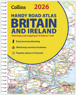
Wegenatlas Britain & Ireland road atlas A5-formaat - Collins • 9780008719227
Wegenatlas Britain & Ireland road atlas - Collins Productomschrijving: This easy-to-use, handy A5 sized road atlas with popular lie-flat spiral binding features extremely clear route planning maps of Britain and Ireland and fits neatly into your glove box or bag. The atlas has been fully updated. The maps of Britain are at 9.9 miles to 1 inch (1:625,000) and the whole of Ireland is co…
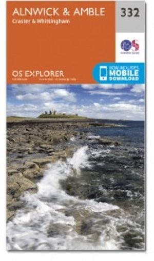
Wandelkaart 332 Alnwick & Amble Northumberland - OSI • 9780319472040
Wandelkaart Alnwick & Amble - Northumberland England Omvat ook: Craster & Whittingham. Productbeschrijving: Kaart nummer 332 in de OS Explorer kaarten reeks heeft betrekking op de Northumbrian kust van Embleton Bay naar Amble en landinwaarts tot zover de bron van de rivier de Aln looptt. Plaatsen om te bezoeken zijn onder andere: Craster, kasteel van Alnwick, Warkworth Castle, Craster …

Plano Adm. Wandkaart Groot-Brittannië 84 x 119 - Lovell Johns • 9781904892687
Wandkaart Groot-Brittannië 84 x 119 - Lovell Johns Productomschrijving: Toont provincies en unitaire autoriteiten in verschillende kleuren. Arrondissementen en districten worden ook op deze kaart getoond, evenals dorpen en steden. Bevat een kleine postcodekaart van Groot-Brittannië met postcodes, evenals bevolkingsgegevens. Deze administratieve kaart van Verenigd Koninkrijk is ideaal v…
