
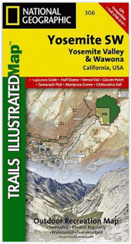
Wandelkaart 306 Yosemite SW- Yosemite Valley - Nat Geo
Yosemite Valley is een populaire toeristische bestemming
Korte omschrijving
Yosemite SW- Yosemite Valley & Wawona - Nat Geo Productomschrijving: De Yosemite Valley is een populaire toeristische bestemming, die elk jaar miljoenen bezoekers ontvangt. De gletsjervallei...

Specificaties
- Uitgever: National Geographic
- ISBN-13: 9781566953627
- HOOFDCATEGORIEËN: Wandelkaart
- Activiteiten: Wandelen, Hiking & Trekking
- Regio: Californië, USA
- Land: Verenigde Staten van Amerika (USA)
- Nationale parken: Yosemeti NP, California USA
- Schaal: 1:40000
- Afmeting: 10x19
- Taal: Engels
Volledige omschrijving
Yosemite SW- Yosemite Valley & Wawona - Nat Geo
Productomschrijving: De Yosemite Valley is een populaire toeristische bestemming, die elk jaar miljoenen bezoekers ontvangt. De gletsjervallei, omlijst door ontzagwekkende granietformaties als El Capitan en Half Dome, staat bekend om zijn dramatische watervallen, reusachtige sequoia's en biologische diversiteit. National Geographic's Trails Illustrated kaart van Yosemite SW: Yosemite Valley en Wawona levert ongeëvenaarde details en waardevolle informatie om u te helpen bij uw verkenning van deze spectaculaire wildernis. Gemaakt in samenwerking met lokale landbeheerders, toont deze deskundig onderzochte kaart belangrijke gebieden van belang, waaronder Yosemite Valley, Wawona, White Wolf, Merced en South Fork Merced rivieren, en Sierra National Forest.
Ontworpen met een breed scala van bezoekers in het achterhoofd, bevat deze kaart gedetailleerde en gemakkelijk te lezen paden met kilometerstanden tussen kruispunten, een nauwkeurig wegennet, kampeerterreinen, trailheads, overnachtingsmogelijkheden, toiletten, en eetgelegenheden. Delen van de Pacific Crest en John Muir trails zijn duidelijk gemarkeerd. Een verscheidenheid aan nuttige informatie over wildernis wandelen en kamperen, vergunningen, veiligheid van beren, en overlevingstips is ook opgenomen. De kaartbasis bevat hoogtelijnen en hoogtes voor toppen en vele meren.
Engelse omschrijving: The Yosemite Valley is a popular tourist destination, hosting millions of visitors each year. The glacial valley framed by such awe-inspiring granite formations as El Capitan and Half Dome is known for its dramatic waterfalls, giant sequoia groves, and biological diversity. National Geographic's Trails Illustrated map of Yosemite SW: Yosemite Valley and Wawona delivers unmatched detail and valuable information to assist you in your exploration of this spectacular wilderness. Created in partnership with local land management agencies, this expertly researched map features key areas of interest including Yosemite Valley, Wawona, White Wolf, Merced and South Fork Merced rivers, and Sierra National Forest.
Designed with a wide range of visitors in mind, this map features detailed and easy to read trails that include mileage between intersections, accurate road network, campgrounds, trailheads, lodging, restrooms, and food services. Sections of the Pacific Crest and John Muir trails are clearly marked. A variety of helpful information about wilderness hiking and camping, permits, bear safety, and survival tips is included as well. The map base includes contour lines and elevations for summits and many lakes.
Every Trails Illustrated map is printed on "Backcountry Tough" waterproof, tear-resistant paper. A full UTM grid is printed on the map to aid with GPS navigation.
Other features found on this map include: Bridalveil Fall, Chowchilla Mountains, El Capitan, Illilouette Falls, Lower Yosemite Fall, Nevada Fall, Ribbon Fall, Sierra National Forest, Silver Strand Falls, Stanislaus National Forest, Upper Yosemite Falls, Vernal Fall, Yosemite National Park, Yosemite Valley.
Locatie op kaart
Overzichtskaarten

NAT GEO California trail maps
NAT GEO California trail maps

Producten op de overzichtskaart
Klik op een product om naar de detailpagina te gaan.
- Wandelkaart 205 Sequoia & Kings Canyon NP - California
- Wandelkaart 206 Yosemite NP - California - Nat Geo
- Wandelkaart 218 Redwood National & State Parks - Nat Geo
- Wandelkaart 221 Death Valley NP - Nevada - Natgeo
- Wandelkaart 226 Joshua Tree NP - California - Nat Geo
- Wandelkaart 256 Mojave National park California - Nat Geo
- Wandelkaart 306 Yosemite SW- Yosemite Valley - Nat Geo
- Wandelkaart 307 Yosemite NP North West - Nat Geo
- Wandelkaart 308 Yosemite NE- Tuolumne Meadows - Nat Geo
- Wandelkaart 309 Yosemite SE - Ansel Adams Wilderness - Nat Geo
- Wandelkaart 322 Mount Whitney California - Nat Geo
- Wandelkaart 803 Lake Tahoe Basin - California - Nat Geo
- Wandelkaart 804 Tahoe National Forest West - Nat Geo
- Wandelkaart 805 Tahoe Nat. Forest East - Sierra Buttes - Nat Geo
- Wandelkaart 809 Mammoth Lakes - Mono Divide - Nat Geo
- Wandelkaart 810 Shaver Lake - Sierra National Forest - Nat Geo

NAT GEO Montana trails map
NAT GEO Montana trails map

Producten op de overzichtskaart
Klik op een product om naar de detailpagina te gaan.
- Wandelkaart 215 Glacier & Waterton Lakes NP - Montana - Nat Geo
- Wandelkaart 301 Longs Peak -Trails Illustrated N. Trails - Nat Geo
- Wandelkaart 302 Yellowstone NP & Old Faithful - Nat Geo
- Wandelkaart 303 Mammoth Hot Springs- Yellowstone - Nat Geo
- Wandelkaart 304 Tower & Canyon Yellowstone NP - Nat Geo
- Wandelkaart 306 Yosemite SW- Yosemite Valley - Nat Geo
- Wandelkaart 314 Many Glacier NP- Waterton lakes - Montana
Artikelen uit dezelfde regio

Wandelkaart 809 Mammoth Lakes - Mono Divide - Nat Geo • 9781566952668
TOPO Wandelkaart 809 - Mammoth Lakes - Mono Divide - National Geographic Productomschrijving: Mammoth Lakes is een stadje in Mono County, California, de enige geintegreerde community in de regio. Gelegen direct ten oosten van Mammoth Mountain. Engelse omschrijving: Explore the magnificent alpine landscape of Mammoth Lakes, Mono Divide with National Geographic's Trails Illustrated map. …

Wandelkaart 803 Lake Tahoe Basin - California - Nat Geo • 9781566953344
TOPO Wandelkaart 803 - Lake Tahoe Basin - California - Nat Geo Productomschrijving: Lake Tahoe Basin is een bosgebied in het Sierra Nevada-gebergte in de Verenigde Staten, dat als National Forest. Het bosgebied ligt verspreid over Placer, El Dorado en Alpine County in Californië en Washoe en Douglas County en Carson City in Nevada. Engelse omschrijving: The largest alpine lake in North…

Wandelkaart 807 Carson-Iceberg- Nat.Geo • 9781566952651
TOPO Wandelkaart 807 - Carson-Iceberg- Nat.Geo Productomschrijving: Een verzameling aan nationale bosgebieden op één kaart en gelegen in Calofornia. Engelse omschrijving: Expertly researched and created in partnership with the U.S. Forest Service and others, National Geographic's Trails Illustrated map of Yuba and American Rivers region of Tahoe National Forest provides an unparalleled…

Wandelgids California & Southwest USA's NP's - Lonely Planet • 9781838696061
Wandelgids California & Southwest USA's National Parks Productomschrijving: Lonely Planet's California and Southwest USA's National Parks is uw paspoort voor het meest actuele advies over wat je moet zien en overslaan. Wandel door de Grand Canyon, bewonder Sequoia en jaag op watervallen in Yosemite; allemaal met je vertrouwde reisgenoot. Duik in het hart van de nationale parken van Califor…

Reisgids Experience California - Lonely Planet • 9781838695613
Experience California met Lonely Planet Productomschrijving: Inspirerende full-color reisfotografie en kaarten in de hele gids. Hoogtepunten en trip builders om je te helpen je reis af te stemmen op je persoonlijke behoeften en interesses. Frisse invalshoeken om u te verrassen met dingen waar u niet aan had gedacht, evenals een frisse kijk op de bekende bezienswaardigheden Insider tips hel…