

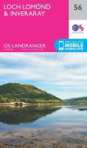
Wandelkaart 56 Loch Lomond & Inveraray- Trossachs NP - OSI
De West Highland Way- & Loch Lomond in het Trossachs NP


Korte omschrijving
Wandelkaarten Highlands, Schotland van Ordnance Survey. Ideaal voor tochten in Schotland.
Wandelkaart Loch Lomond & Inveraray - Schotland Productbeschrijving: Gezegd dat dit de toegangspoort tot de hooglanden is, heeft Inveraray een breed scala aan attracties in aanbod van Invera...

Specificaties
- Uitgever: Ordnance Survey
- ISBN-13: 9780319261545
- HOOFDCATEGORIEËN: Wandelkaart
- Activiteiten: Wandelen, Hiking & Trekking
- Regio: Highlands, Schotland
- Land: Schotland
- Nationale parken: The Trossarchs National Park, Schotland
- TOPO's & Stafkaarten: Topografisch wandelen
- Schaal: 1:50000
- Taal: Engels
- Reeks/Serie: Landranger Series OSI
Volledige omschrijving
Wandelkaart Loch Lomond & Inveraray - Schotland
Productbeschrijving: Gezegd dat dit de toegangspoort tot de hooglanden is, heeft Inveraray een breed scala aan attracties in aanbod van Inveraray Castle en tuinen tot wandelen in de nabijgelegen Glens Shira en Aray. OS Landranger kaart 56 toont ook de West Highland Way, die op zijn beurt langs de oevers van Loch Lomond in het Trossachs Nationaal Park. De loch zelf is de grootste hoeveelheid zoet water op het vasteland van Groot-Brittannië.
De OS Landranger kaarten reeks heeft betrekking op Groot-Brittannië met 204 gedetailleerde kaarten, perfect voor dagtochten en korte pauzes. Elke kaart bevat alle informatie die u nodig heeft om dit lokaal gebied te leren kennen en omvat plaatsen van belang, toeristische informatie, picknickplaatsen en campings, plus doorgangsrechten informatie voor Engeland en Wales.
Productdiscription: Said to be the gateway to the Highlands, Inveraray has a wide range of attractions on offer from Inveraray Castle and Gardens to walking in the nearby Glens Shira and Aray. OS Landranger map 56 also shows the West Highland Way, which passes along the banks of Loch Lomond in the Trossachs National Park. The loch itself is the largest body of freshwater in mainland Britain.
The OS Landranger Map series covers Great Britain with 204 detailed maps, perfect for day trips and short breaks. Each map provides all the information you need to get to know your local area and includes places of interest, tourist information, picnic areas and camp sites, plus Rights of Way information for England and Wales.
Locatie op kaart
Gekoppelde artikelen
Wandelkaart 56 Loch Lomond & Inveraray- Trossachs NP - OSI • 9780319261545
standaard versieWandelkaart Loch Lomond & Inveraray - Schotland Productbeschrijving: Gezegd dat dit de toegangspoort tot de hooglanden is, heeft Inveraray een breed scala aan attracties in aanbod van Inveraray Castle en tuinen tot wandelen in de nabijgelegen Glens Shira en Aray. OS Landranger kaart 56 toont ook de West Highland Way, die op zijn beurt langs de oevers van Loch Lomond in het Trossachs Nation…

Wandelkaart 56 Loch Lomond & Inveraray- Trossachs NP - OSI • 9780319473795
weatherproof versieWandelkaart Loch Lomond & Inverary - Trossachs NP Schotland Productbeschrijving: Als toegangspoort tot de highland's, heeft Inveraray een breed scala aan attracties in aanbod, van Inveraray Castle tot wandelen in de nabijgelegen Glens, Shira en Aray. OS Landranger kaart 56 toont ook de West Highland Way, die op hun beurt langs de oevers van Loch Lomond in het Trossachs Nationaal Park ligge…
Overzichtskaarten
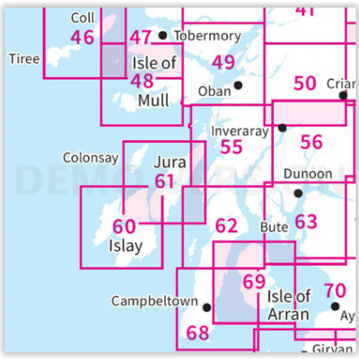
OSI Landranger & Landranger Active - Zuid-West Schotland - Schotse eilanden & Highland's
OSI Landranger & Landranger Active - Zuid-West Schotland - Schotse eilanden & Highland's

Producten op de overzichtskaart
Klik op een product om naar de detailpagina te gaan.
- Wandelkaart 46 Coll & Tiree Isles- Inner hybriden - OSI
- Wandelkaart 46 Coll & Tiree Isles- Binnen hybriden - OSI
- Wandelkaart 47 Tobermory & North Mull - Schotland - OSI
- Wandelkaart 47 Tobermory & North Mull- Argyl & Bute - OSI
- Wandelkaart 48 Iona & West Mull - Inner Hybrids - OSI
- Wandelkaart 48 Iona & West Mull - Schotland - OSI
- Wandelkaart 49 Oban & East Mull- Schotland - OSI
- Wandelkaart 49 Oban & East Mull- Argyl & Bute Schotland - OSI
- Wandelkaart 50 Glen Orchy & Loch Etive- Argyl & Bute - OSI
- Wandelkaart 50 Glen Orchy & Loch Etive- Schotland - OSI
- Wandelkaart 55 Lochgilphead & Loch Awe - OSI
- Wandelkaart 55 Lochgilphead & Loch Awe - OSI
- Wandelkaart 56 Loch Lomond & Inveraray- Trossachs NP - OSI
- Wandelkaart 56 Loch Lomond & Inveraray- Trossachs NP - OSI
- Wandelkaart 60 Islay- Inner Hybrids Schotland - OSI
- Wandelkaart 60 Islay- Inner Hybrids Schotland - OSI
- Wandelkaart 61 Jura & Colonsay - Inner Hybrids - OSI
- Wandelkaart 61 Jura & Colonsay - Schotland - OSI
- Wandelkaart 62 North Kintyre & Tarbert - Schotland - OSI
- Wandelkaart 62 North Kintyre & Tarbert - Schotland - OSI
- Wandelkaart 63 Firth of Clyde- Argyl & Bute - Schotland - OSI
- Wandelkaart 63 Firth of Clyde- Argyl & Bute - Schotland - OSI
- Wandelkaart 68 South Kintyre & Campbeltown - OSI
- Wandelkaart 68 South Kintyre & Campbeltown - OSI
- Wandelkaart 69 Isle of Arran- Inner Hybrids - OSI
- Wandelkaart 69 Isle of Arran- Inner Hybrids - OSI
- Wandelkaart 70 Ayr- Kilmarnock & Troon- Schotland - OSI
- Wandelkaart 70 Ayr- Kilmarnock & Troon- Schotland - OSI
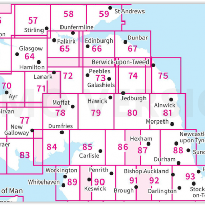
OSI Landranger & Landranger Active - Zuid Schotland & Scotisch Borders
OSI Landranger & Landranger Active - Zuid Schotland & Scotisch Borders
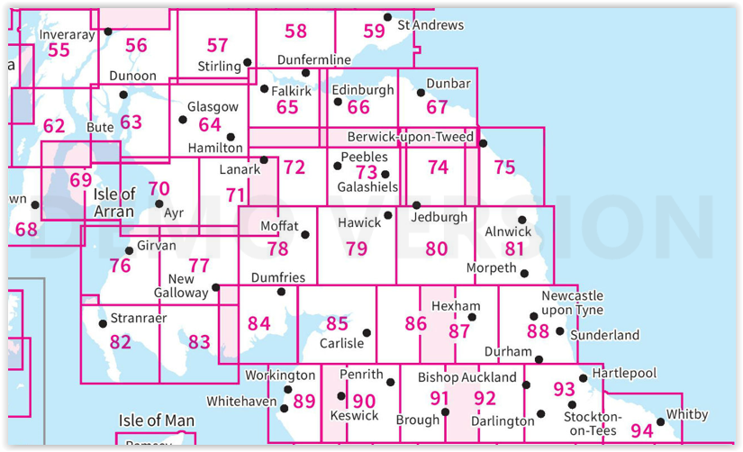
Producten op de overzichtskaart
Klik op een product om naar de detailpagina te gaan.
- Wandelkaart 55 Lochgilphead & Loch Awe - OSI
- Wandelkaart 55 Lochgilphead & Loch Awe - OSI
- Wandelkaart 56 Loch Lomond & Inveraray- Trossachs NP - OSI
- Wandelkaart 56 Loch Lomond & Inveraray- Trossachs NP - OSI
- Wandelkaart 57 Stirling & The Trossachs NP - Highland's - OSI
- Wandelkaart 57 Stirling & The Trossachs NP - Schotland - OSI
- Wandelkaart 58 Perth & Alloa - Perth & Kinross - OSI
- Wandelkaart 58 Perth & Alloa - perth & Kinross - OSI
- Wandelkaart 59 St-Andrews- Fife Schotland - OSI
- Wandelkaart 59 St-Andrews- Fife- Schotland - OSI
- Wandelkaart 62 North Kintyre & Tarbert - Schotland - OSI
- Wandelkaart 62 North Kintyre & Tarbert - Schotland - OSI
- Wandelkaart 63 Firth of Clyde- Argyl & Bute - Schotland - OSI
- Wandelkaart 63 Firth of Clyde- Argyl & Bute - Schotland - OSI
- Wandelkaart 64 Glasgow City Schotland - OSI
- Wandelkaart 64 Glasgow City Schotland- OSI
- Wandelkaart 65 Falkirk & Linlithgow - Edinburgh - OSI
- Wandelkaart 65 Falkirk & Linlithgow - West Schotland - OSI
- Wandelkaart 66 Edinburgh - Western Schotland - OSI
- Wandelkaart 66 Edinburgh - Western Schotland - OSI
- Wandelkaart 67 Duns- Dunbar & Eyemouth- Schotland - OSI
- Wandelkaart 67 Duns- Dunbar & Eyemouth- Schotland - OSI
- Wandelkaart 68 South Kintyre & Campbeltown - OSI
- Wandelkaart 68 South Kintyre & Campbeltown - OSI
- Wandelkaart 69 Isle of Arran - Inner Hybrids - OSI
- Wandelkaart 69 Isle of Arran - Inner Hybrids - OSI
- Wandelkaart 70 Ayr- Kilmarnock & Troon- Schotland - OSI
- Wandelkaart 70 Ayr- Kilmarnock & Troon- Schotland - OSI
- Wandelkaart 71 Lanark & Upper Nithsdale - OSI
- Wandelkaart 71 Lanark & Upper Nithsdale - OSI
- Wandelkaart 72 Upper Clyde Valley- Lanarkshire - OSI
- Wandelkaart 72 Upper Clyde Valley- Lanarkshire - OSI
- Wandelkaart 73 Peebles- Galashiels & Selkirk - Schotland - OSI
- Wandelkaart 73 Peebles- Galashiels & Selkirk - Schotland - OSI
- Wandelkaart 74 Kelso & Coldstream - Schotland - OSI
- Wandelkaart 74 Kelso & Coldstream - Schotland - OSI
- Wandelkaart 75 Berwick-upon-Tweed- England - OSI
- Wandelkaart 75 Berwick-upon-Tweed - OSI
- Wandelkaart 76 Girvan- South Ayrshire - Schotland - OSI
- Wandelkaart 76 Girvan- South Ayrshire -Schotland - OSI
- Wandelkaart 77 Dalmellington & New Galloway- Schotland - OSI
- Wandelkaart 77 Dalmellington & New Galloway- Schotland - OSI
- Wandelkaart 78 Nithsdale & Annandale- Schotland - OSI
- Wandelkaart 78 Nithsdale & Annandale- Schotland - OSI
- Wandelkaart 79 Hawick & Eskdale - Schotland - OSI
- Wandelkaart 79 Hawick & Eskdale - Schotland - OSI
- Wandelkaart 80 Cheviot Hills & Kielder Water - England - OSI
- Wandelkaart 80 Cheviot Hills & Kielder Water - England - OSI
- Wandelkaart 81 Alnwick & Morpeth - Northumberland - OSI
- Wandelkaart 82 Stranraer & Glenluce - Schotland - OSI
- Wandelkaart 82 Stranraer & Glenluce - Schotland - OSI
- Wandelkaart 83 Newton Stewart & Kirkcudbright- Schotland - OSI
- Wandelkaart 83 Newton Stewart & Kirkcudbright- Schotland - OSI
- Wandelkaart 84 Dumfries & Castle Douglas- Schotland - OSI
- Wandelkaart 84 Dumfries & Castle Douglas- Schotland - OSI
- Wandelkaart 85 Carlisle & Solway Firth- Cumbria England - OSI
- Wandelkaart 85 Carlisle & Solway Firth- Cumbria England - OSI
- Wandelkaart 86 Haltwhistle & Brampton - OSI
- Wandelkaart 86 Haltwhistle & Brampton - OSI
- Wandelkaart 87 Hexham & Haltwhistle- England - OSI
- Wandelkaart 87 Hexham & Haltwhistle- England - OSI
- Wandelkaart 88 Newcastle upon Tyne- N.E. England - OSI
- Wandelkaart 88 Newcastle upon Tyne- N.E. England - OSI
- Wandelkaart 89 West Cumbria England - OSI
- Wandelkaart 89 West Cumbria England - OSI
- Wandelkaart 91 Appleby-in-Westmorland - OSI
- Wandelkaart 91 Appleby-in-Westmorland - OSI
- Wandelkaart 92 Barnard Castle Teesdale - England - OSI
- Wandelkaart 92 Barnard Castle Teesdale - England - OSI
- Wandelkaart 93 Middlesbrough & Darlington- England - OSI
- Wandelkaart 93 Middlesbrough & Darlington- England - OSI
- Wandelkaart 94 Whitby & Esk Dale- North Yorkshire - OSI
- Wandelkaart 94 Whitby & Esk Dale- North Yorkshire - OSI
Artikelen uit dezelfde regio
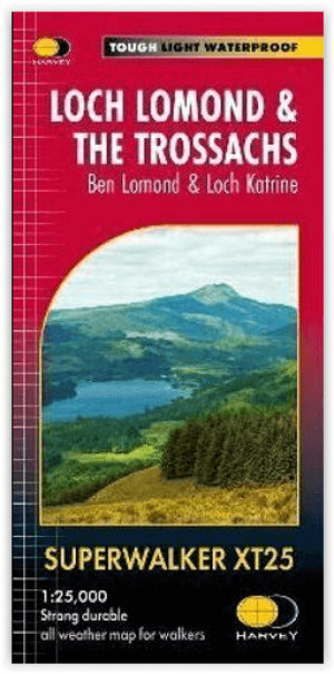
Wandelkaart XT25 Loch Lomond & The Trossachs - Harvey maps • 9781851376445
Loch Lomond & The Trossachs - Harvey maps Productomschrijving: Ideaal om het ganse gebied van de Great Trossachs Forest en Queen Elizabeth Forest Park te ontdekken. Er gaat niets boven een Schots nationaal park. Omvat: Ben Vorlich, Ben Ledi en Ben Venue - 7 Munros, 7 Corbetts en 6 Grahams - Lichtgewicht, gedetailleerd, duidelijk en makkelijk te lezen - Geprint op sterk, 100% wa…

Wandelgids Ben Nevis & Glen Coe Schotland - Cicerone • 9781852848712
Wandelgids - Ben Nevis & Glen Coe Schotland - Cicerone Productomschrijving: Wandelgids voor de regio van Schotland, de Ben Nevis en Glen Coe, en omvat 100 ingedeelde routes van tussen de 2 tot en met 26km. De routes variëren van zachte wandelingen tot Bothy treks en omvatten 43 Munro's en 3 scrambles. De routes omvatten wandelingen in de buurt van Kinlochleven, Fort William, de Grey Corrie…
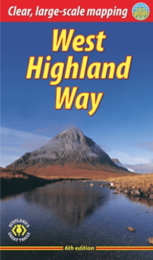
Wandelgids The West Highland Way - Rucksack Readers • 9781913817213
The West Highland Way - Rucksack Readers Productomschrijving: Een unieke intussen zeer gekende wandelroute, die loopt van Milngavie nabij Glasgow tot Fort William door de Schotse Hooglanden. De Route is 152 km Lang en brengt u door de westelijke Highlands van Schotland starten vanuit Glasgow. Engelse omschrijving: The West Highland Way is the first, and remains the most famous, of Scot…

Reisgids Scottish Highlands & Islands - Rough guides • 9780241272312
Scottish Highlands & Islands - Rough guides Product description: This fully updated The Rough Guide to Scottish Highlands and Islands is the ultimate guidebook to the captivating remote reaches of Scotland. From the divine seafood offerings at Loch Fyne to the whisky distilleries on Islay, this is a place for indulging. It’s also a hotspot for outdoor activities, whether you decide to bag …

Wandelkaart 443 Ben Klibreck & Ben Armine Schotland - OSI • 9780319472958
Wandelkaart Ben Klibreck & Ben Armine - Highland's Schotland Productbeschrijving: OS Explorer kaart 443 toont de Munro Meall nan Con, Ben Klibreck, Loch Choire en Loch Shin. Toegang vanaf de A836 aan de westzijde van de kaart - alleen onopgemaakte sporen en voetpaden nemen u verder. De OS Explorer kaart voor Ben Klibreck & Ben Armine is beschikbaar in zowel de standaard papieren versie als…