

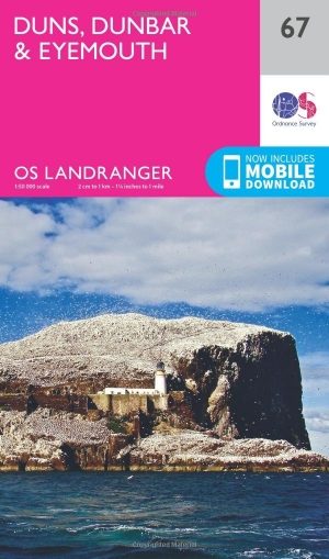
Wandelkaart 67 Duns- Dunbar & Eyemouth- Schotland - OSI
Omvat Edinburgh- en de steden Duns- Dunbar & East Linton


Korte omschrijving
Wandelkaarten Schotse grenzen van Ordnance Survey. Ideaal voor tochten in Schotland.
Wandelkaart Duns- Dunbar & Eyemouth - Schotland Productbeschrijving: OS Landranger kaart 67 toont de oostkust in de buurt van Edinburgh, en omvat de steden Duns, Dunbar, East Linton, Eyemout...

Specificaties
- Uitgever: Ordnance Survey
- ISBN-13: 9780319261651
- HOOFDCATEGORIEËN: Wandelkaart
- Activiteiten: Wandelen, Hiking & Trekking
- Regio: Schotse grenzen
- Land: Schotland
- TOPO's & Stafkaarten: Topografisch wandelen
- Schaal: 1:50000
- Taal: Engels
- Reeks/Serie: Landranger Series OSI
Volledige omschrijving
Wandelkaart Duns- Dunbar & Eyemouth - Schotland
Productbeschrijving: OS Landranger kaart 67 toont de oostkust in de buurt van Edinburgh, en omvat de steden Duns, Dunbar, East Linton, Eyemouth en Cosckburnspath. Het markeert het oostelijke uiteinde van de Southern Upland Way, en u kunt het ook verkennen van de Lammermuir Hills.
De OS Landranger kaarten reeks heeft betrekking op Groot-Brittannië met 204 gedetailleerde kaarten, perfect voor dagtochten en korte pauzes. Elke kaart bevat alle informatie die u nodig heeft om dit lokaal gebied te leren kennen en omvat plaatsen van belang, toeristische informatie, picknickplaatsen en campings, plus doorgangsrechten informatie voor Engeland en Wales.
Productdiscription: OS Landranger map 67 shows the east coast near Edinburgh, and includes the towns of Duns, Dunbar, East Linton, Eyemouth and Cosckburnspath. It marks the eastern end of the Southern Upland Way, and you can also explore the Lammermuir Hills.
The OS Landranger Map series covers Great Britain with 204 detailed maps, perfect for day trips and short breaks. Each map provides all the information you need to get to know your local area and includes places of interest, tourist information, picnic areas and camp sites, plus Rights of Way information for England and Wales.
Locatie op kaart
Gekoppelde artikelen
Wandelkaart 67 Duns- Dunbar & Eyemouth- Schotland - OSI • 9780319261651
standaard versieWandelkaart Duns- Dunbar & Eyemouth - Schotland Productbeschrijving: OS Landranger kaart 67 toont de oostkust in de buurt van Edinburgh, en omvat de steden Duns, Dunbar, East Linton, Eyemouth en Cosckburnspath. Het markeert het oostelijke uiteinde van de Southern Upland Way, en u kunt het ook verkennen van de Lammermuir Hills. De OS Landranger kaarten reeks heeft betrekking op Groot-Br…

Wandelkaart 67 Duns- Dunbar & Eyemouth- Schotland - OSI • 9780319473900
weatherproof versieWandelkaart Duns- Dunbar & Eyemouth - Schotland Productbeschrijving: OS Landranger kaart 67 toont de oostkust van de buurt van Edinburgh, en omvat de steden Duns, Dunbar, East Linton, Eyemouth en Cosckburnspath. Het markeert het oostelijke uiteinde van de Southern Upland Way, en u kunt ook het verkennen van de Lammermuir Hills. De OS Landranger kaarten reeks heeft betrekking op Groot-Britt…
Overzichtskaarten
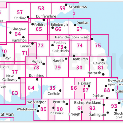
OSI Landranger & Landranger Active - Zuid Schotland & Scotisch Borders
OSI Landranger & Landranger Active - Zuid Schotland & Scotisch Borders
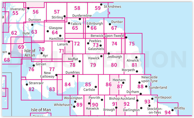
Producten op de overzichtskaart
Klik op een product om naar de detailpagina te gaan.
- Wandelkaart 55 Lochgilphead & Loch Awe - OSI
- Wandelkaart 55 Lochgilphead & Loch Awe - OSI
- Wandelkaart 56 Loch Lomond & Inveraray- Trossachs NP - OSI
- Wandelkaart 56 Loch Lomond & Inveraray- Trossachs NP - OSI
- Wandelkaart 57 Stirling & The Trossachs NP - Highland's - OSI
- Wandelkaart 57 Stirling & The Trossachs NP - Schotland - OSI
- Wandelkaart 58 Perth & Alloa - Perth & Kinross - OSI
- Wandelkaart 58 Perth & Alloa - perth & Kinross - OSI
- Wandelkaart 59 St-Andrews- Fife Schotland - OSI
- Wandelkaart 59 St-Andrews- Fife- Schotland - OSI
- Wandelkaart 62 North Kintyre & Tarbert - Schotland - OSI
- Wandelkaart 62 North Kintyre & Tarbert - Schotland - OSI
- Wandelkaart 63 Firth of Clyde- Argyl & Bute - Schotland - OSI
- Wandelkaart 63 Firth of Clyde- Argyl & Bute - Schotland - OSI
- Wandelkaart 64 Glasgow City Schotland - OSI
- Wandelkaart 64 Glasgow City Schotland- OSI
- Wandelkaart 65 Falkirk & Linlithgow - Edinburgh - OSI
- Wandelkaart 65 Falkirk & Linlithgow - West Schotland - OSI
- Wandelkaart 66 Edinburgh - Western Schotland - OSI
- Wandelkaart 66 Edinburgh - Western Schotland - OSI
- Wandelkaart 67 Duns- Dunbar & Eyemouth- Schotland - OSI
- Wandelkaart 67 Duns- Dunbar & Eyemouth- Schotland - OSI
- Wandelkaart 68 South Kintyre & Campbeltown - OSI
- Wandelkaart 68 South Kintyre & Campbeltown - OSI
- Wandelkaart 69 Isle of Arran - Inner Hybrids - OSI
- Wandelkaart 69 Isle of Arran - Inner Hybrids - OSI
- Wandelkaart 70 Ayr- Kilmarnock & Troon- Schotland - OSI
- Wandelkaart 70 Ayr- Kilmarnock & Troon- Schotland - OSI
- Wandelkaart 71 Lanark & Upper Nithsdale - OSI
- Wandelkaart 71 Lanark & Upper Nithsdale - OSI
- Wandelkaart 72 Upper Clyde Valley- Lanarkshire - OSI
- Wandelkaart 72 Upper Clyde Valley- Lanarkshire - OSI
- Wandelkaart 73 Peebles- Galashiels & Selkirk - Schotland - OSI
- Wandelkaart 73 Peebles- Galashiels & Selkirk - Schotland - OSI
- Wandelkaart 74 Kelso & Coldstream - Schotland - OSI
- Wandelkaart 74 Kelso & Coldstream - Schotland - OSI
- Wandelkaart 75 Berwick-upon-Tweed- England - OSI
- Wandelkaart 75 Berwick-upon-Tweed - OSI
- Wandelkaart 76 Girvan- South Ayrshire - Schotland - OSI
- Wandelkaart 76 Girvan- South Ayrshire -Schotland - OSI
- Wandelkaart 77 Dalmellington & New Galloway- Schotland - OSI
- Wandelkaart 77 Dalmellington & New Galloway- Schotland - OSI
- Wandelkaart 78 Nithsdale & Annandale- Schotland - OSI
- Wandelkaart 78 Nithsdale & Annandale- Schotland - OSI
- Wandelkaart 79 Hawick & Eskdale - Schotland - OSI
- Wandelkaart 79 Hawick & Eskdale - Schotland - OSI
- Wandelkaart 80 Cheviot Hills & Kielder Water - England - OSI
- Wandelkaart 80 Cheviot Hills & Kielder Water - England - OSI
- Wandelkaart 81 Alnwick & Morpeth - Northumberland - OSI
- Wandelkaart 82 Stranraer & Glenluce - Schotland - OSI
- Wandelkaart 82 Stranraer & Glenluce - Schotland - OSI
- Wandelkaart 83 Newton Stewart & Kirkcudbright- Schotland - OSI
- Wandelkaart 83 Newton Stewart & Kirkcudbright- Schotland - OSI
- Wandelkaart 84 Dumfries & Castle Douglas- Schotland - OSI
- Wandelkaart 84 Dumfries & Castle Douglas- Schotland - OSI
- Wandelkaart 85 Carlisle & Solway Firth- Cumbria England - OSI
- Wandelkaart 85 Carlisle & Solway Firth- Cumbria England - OSI
- Wandelkaart 86 Haltwhistle & Brampton - OSI
- Wandelkaart 86 Haltwhistle & Brampton - OSI
- Wandelkaart 87 Hexham & Haltwhistle- England - OSI
- Wandelkaart 87 Hexham & Haltwhistle- England - OSI
- Wandelkaart 88 Newcastle upon Tyne- N.E. England - OSI
- Wandelkaart 88 Newcastle upon Tyne- N.E. England - OSI
- Wandelkaart 89 West Cumbria England - OSI
- Wandelkaart 89 West Cumbria England - OSI
- Wandelkaart 91 Appleby-in-Westmorland - OSI
- Wandelkaart 91 Appleby-in-Westmorland - OSI
- Wandelkaart 92 Barnard Castle Teesdale - England - OSI
- Wandelkaart 92 Barnard Castle Teesdale - England - OSI
- Wandelkaart 93 Middlesbrough & Darlington- England - OSI
- Wandelkaart 93 Middlesbrough & Darlington- England - OSI
- Wandelkaart 94 Whitby & Esk Dale- North Yorkshire - OSI
- Wandelkaart 94 Whitby & Esk Dale- North Yorkshire - OSI
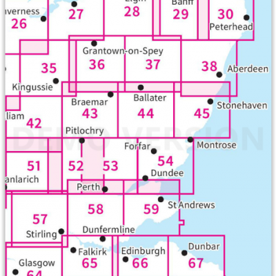
OSI Landranger & Landranger Active - Noord Oost Schotland - Cairngorms
OSI Landranger & Landranger Active - Noord Oost Schotland - Cairngorms

Producten op de overzichtskaart
Klik op een product om naar de detailpagina te gaan.
- Wandelkaart 21 Dornoch & Alness- Highland's - Schotland - OSI
- Wandelkaart 21 Dornoch & Alness- Highland's - Schotland - OSI
- Wandelkaart 26 Inverness & Loch Ness- Schotland - OSI
- Wandelkaart 26 Inverness & Loch Ness- Schotland - OSI
- Wandelkaart 27 Nairn & Forres- Highland's Schotland - OSI
- Wandelkaart 27 Nairn & Forres- Highland's Schotland - OSI
- Wandelkaart 28 Elgin & Dufftown & Moray - Schotland- OSI
- Wandelkaart 28 Elgin & Dufftown- Moray - Schotland - OSI
- Wandelkaart 29 Banff & Huntly - Schotland - OSI
- Wandelkaart 29 Banff & Huntly - Schotland - OSI
- Wandelkaart 30 Fraserburgh- Aberdeenshire Schotland - OSI
- Wandelkaart 30 Fraserburgh- Aberdeenshire Schotland - OSI
- Wandelkaart 35 Kingussie & Cairngorms NP - Highland's - OSI
- Wandelkaart 35 Kingussie & Cairngorms NP - Highland's - OSI
- Wandelkaart 36 Grantown & Aviemore - Cairngorms NP - OSI
- Wandelkaart 36 Grantown & Aviemore - Cairngorms - OSI
- Wandelkaart 37 Strathdon & Alford - Schotland - OSI
- Wandelkaart 37 Strathdon & Alford - Schotland - OSI
- Wandelkaart 38 Aberdeen- Schotland - OSI
- Wandelkaart 38 Aberdeen- Schotland - OSI
- Wandelkaart 42 Glen Garry & Loch Rannoch - OSI
- Wandelkaart 42 Glen Garry & Loch Rannoch - OSI
- Wandelkaart 43 Braemar & Blair Athol - Perth & Kinross - OSI
- Wandelkaart 43 Braemar & Blair Athol - Perth & Kinross - OSI
- Wandelkaart 44 Ballater & Glen Clova - Aberdeenshire - OSI
- Wandelkaart 44 Ballater & Glen Clova - Aberdeenshire - OSI
- Wandelkaart 45 Stonehaven & Banchory - OSI
- Wandelkaart 45 Stonehaven - Banchory - OSI
- Wandelkaart 51 Loch Tay & Glen Dochart- Highland's - OSI
- Wandelkaart 51 Loch Tay & Glen Dochart- Highland's - OSI
- Wandelkaart 52 Pitlochry & Crieff- Perth & Kinross - OSI
- Wandelkaart 52 Pitlochry & Crieff- Perth & Kinross - OSI
- Wandelkaart 53 Blairgowrie & Forest of Alyth- Schotland - OSI
- Wandelkaart 53 Blairgowrie & Forest of Alyth- Schotland - OSI
- Wandelkaart 54 Dundee & Montrose- West Schotland - OSI
- Wandelkaart 54 Dundee & Montrose- West Schotland - OSI
- Wandelkaart 57 Stirling & The Trossachs NP - Highland's - OSI
- Wandelkaart 58 Perth & Alloa - perth & Kinross - OSI
- Wandelkaart 58 Perth & Alloa - Perth & Kinross - OSI
- Wandelkaart 59 St-Andrews- Fife Schotland - OSI
- Wandelkaart 59 St-Andrews- Fife- Schotland - OSI
- Wandelkaart 64 Glasgow City Schotland - OSI
- Wandelkaart 65 Falkirk & Linlithgow - Edinburgh - OSI
- Wandelkaart 65 Falkirk & Linlithgow - West Schotland - OSI
- Wandelkaart 66 Edinburgh - Western Schotland - OSI
- Wandelkaart 66 Edinburgh - Western Schotland - OSI
- Wandelkaart 67 Duns- Dunbar & Eyemouth- Schotland - OSI
- Wandelkaart 67 Duns- Dunbar & Eyemouth- Schotland - OSI
- Wandelkaart 71 Lanark & Upper Nithsdale - OSI
- Wandelkaart 71 Lanark & Upper Nithsdale - OSI
- Wandelkaart 72 Upper Clyde Valley- Lanarkshire - OSI
- Wandelkaart 72 Upper Clyde Valley- Lanarkshire - OSI
- Wandelkaart 73 Peebles- Galashiels & Selkirk - Schotland - OSI
- Wandelkaart 73 Peebles- Galashiels & Selkirk - Schotland - OSI
- Wandelkaart 74 Kelso & Coldstream - Schotland - OSI
- Wandelkaart 74 Kelso & Coldstream - Schotland - OSI
- Wandelkaart 75 Berwick-upon-Tweed - OSI
- Wandelkaart 75 Berwick-upon-Tweed - OSI
Artikelen uit dezelfde regio
Wandelkaart 74 Kelso & Coldstream - Schotland - OSI • 9780319473979
Wandelkaart Kelso & Coldstream- Scotish borders - Schotland Productbeschrijving: De OS Landranger kaarten reeks heeft betrekking op Groot-Brittannië met 204 gedetailleerde kaarten, perfect voor dagtochten en korte pauzes. Elke kaart bevat alle informatie die u nodig heeft om dit lokaal gebied te leren kennen en omvat plaatsen van belang, toeristische informatie, picknickplaatsen en camping…

Wandelkaart 74 Kelso & Coldstream - Schotland - OSI • 9780319261729
Wandelkaart Kelso & Coldstream - Schotland Productbeschrijving: De steden van Kelso en Coldstream bevinden zich net over de Schotse grens. Kaart OS Landranger 74 omvat ook Duns, Eccles, Paxton, The Cheviot, Branxton, Blythe, onderdeel van de Pennine Way en deel van de Southern Upland Way, alsmede een klein gedeelte van het schilderachtige Northumberland National Park. De OS Landranger …
Wandelkaart 331 Teviotdale South Scotish Borders - OSI • 9780319472033
Wandelkaart Teviotdale South - Schotish Borders Productbeschrijving: OS Explorer kaart 331 omvat de rivier Teviot, Teviotdale, de stad van Hawick en de omliggende dorpen. Het terrein is gevarieerd, met zachte valleien oplopend tot enkele steile hellingen en half hoge pieken. De OS Explorer kaart voor Teviotdale zuiden is beschikbaar in zowel de standaard papieren versie als de weerbestendi…

Wandelkaart OL37 Cowal East- Dunoon & Iverary - OS • 9780319242766
Wandelkaart Cowal East- Dunoon & Iverary - OS Productomschrijving: Cowal East- Dunoon & Iverary, & Part of Loch Lomond & The Trossachs National Part. Omvat: Cowal East- Dunoon & Iverary, & Part of Loch Lomond & The Trossachs National Part, Argyll Forest Park, Kyles of Bute National Scenic Area, Cowal Way & the West Island Way. Ontdek de OL-serie van Ordnance Survey: De OL-serie (…
Wandelgids The Borders Abbeys Way - Cicerone • 9781852849801
Wandelgids - The Borders Abbeys Way - Cicerone Productomschrijving: Deze gids brengt u langs een 109 km lange afstand pad op- en rond het Schotse grensgebied. Langs de route bevinden zich 4 van de beroemste oude Schotse Abbey's. De route start en eindigd in Tweedbank Schotland, en loopt voor zo'n dikke 109 km. De gids beschrijft een dikke 6 etappes en is zeer geschiedenisrijk. Goed voor me…