

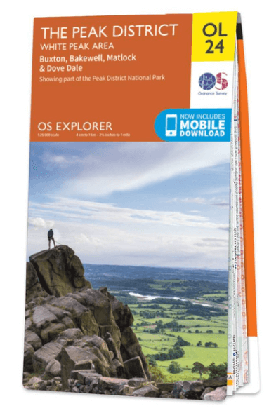
Wandelkaart OL24 Peak District & White Peak area - OS
Buxton- Bakewell- Matlock & Dove Dale- Peak district NP
Korte omschrijving
Wandelkaarten Derbyshire & Peak District, England van Ordnance Survey. Ideaal voor tochten in England.
Wandelkaart Peak District & White Peak area - OS Productomschrijving: Peak District & White Peak area, Derbyshire England Omvat: Buxton, Bakewell, Matlock & Dove Dale, with parts of the...

Specificaties
- Uitgever: Ordnance Survey
- ISBN-13: 9780319263846
- HOOFDCATEGORIEËN: Wandelkaart
- Activiteiten: Wandelen, Hiking & Trekking
- Auteur: Ordnance Survey
- Regio: Derbyshire & Peak District, England
- Land: England
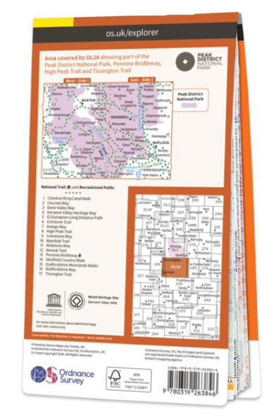
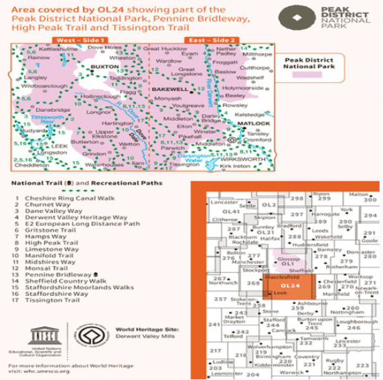
- Lange afstand wandelroutes: Pennine Bridleway, England (330 km)
- Nationale parken: Peak District NP, Derbyshire UK
- TOPO's & Stafkaarten: Topografisch wandelen
- Schaal: 1:25000
- Taal: Engels
- Reeks/Serie: Explorer Series OS
- De Engelse Graafschappen: Derbyshire, South Yorkshire
- De Nationale Parken: Peak District Nationaal Park, England
Volledige omschrijving
Wandelkaart Peak District & White Peak area - OS
Productomschrijving: Peak District & White Peak area, Derbyshire England
Omvat: Buxton, Bakewell, Matlock & Dove Dale, with parts of the Peak district National Park.
Ontdek de OL-serie van Ordnance Survey:
De OL-serie (Outdoor Leisure) van Ordnance Survey is dé referentie voor wie gaat wandelen op de Britse eilanden. Deze topografische kaarten maken deel uit van de Explorer-reeks en bieden ongeëvenaarde nauwkeurigheid en detail op een schaal van 1:25.000. Perfect voor wandelaars, hikers en outdoorliefhebbers.
Waarom kiezen voor de OL Explorer-kaarten?
Gedetailleerde topografie: Elk hekje, pad, beekje en hoogteverschil staat erop.
Ingetekende National Trails: Bekende wandelroutes zoals de South West Coast Path, Hadrian’s Wall Path en Pennine Way zijn duidelijk gemarkeerd.
Betrouwbaarheid: Ordnance Survey is al decennialang de standaard voor kaarten in het VK.
Weerbestendige versies beschikbaar – ideaal voor gebruik in weer en wind.
De beste keuze voor wandelaars
Vergeet generieke wandelkaarten. Met de OL-serie krijg je precieze, actuele informatie, zodat je zonder zorgen op pad kunt.
KOOP NU UW TOPOGRAFISCHE WANDELKAART
Bekijk ons aanbod en kies de OL-kaart die past bij jouw volgende wandelroute. Wandel slim, wandel met Ordnance Survey. wandelroute. Wandel slim, wandel met Ordnance Survey.
Overzichtskaarten

OSI Explorer & Explorer Active - Midden Engeland - Midlands
OSI Explorer & Explorer Active - Midden Engeland - Midlands

Producten op de overzichtskaart
Klik op een product om naar de detailpagina te gaan.
- Wandelkaart 180 Oxford- England - OSI
- Wandelkaart 181 Chiltern Hills North AONB- Wycombe - OSI
- Wandelkaart 182 St-Albans & Hatfield- Hertfordshire - OSI
- Wandelkaart 189 Hereford & Ross-on-Wye- England - OSI
- Wandelkaart 190 Malvern Hills AONB & Bredon Hill - OSI
- Wandelkaart 191 Banbury- Bicester & Chipping Norton- OSI
- Wandelkaart 192 Buckingham & Milton Keynes - OSI
- Wandelkaart 193 Luton & Stevenage- Bedfordshire - OSI
- Wandelkaart 194 Hertford & Bishop's Stortford - OSI
- Wandelkaart 202 Leominster & Bromyard Hererfordshire - OSI
- Wandelkaart 203 Ludlow & Shropshire Hills AONB - OSI
- Wandelkaart 204 Worcester & Droitwich Spa - OSI
- Wandelkaart 205 Stratford-upon-Avon & Evesham - OSI
- Wandelkaart 206 Edge Hill & Fenny Compton - OSI
- Wandelkaart 207 Newport Pagnell & Northampton - OSI
- Wandelkaart 208 Bedford & St Neots- Bedforeshire - OSI
- Wandelkaart 209 Cambridge - England - OSI
- Wandelkaart 217 Long Mynd & Wenlock Edge - OSI
- Wandelkaart 218 Kidderminster & Wyre Forest - OSI
- Wandelkaart 219 Wolverhampton & Dudley - OSI
- Wandelkaart 220 Birmingham- West Midlands - OSI
- Wandelkaart 221 Coventry & Warwickshire - OSI
- Wandelkaart 222 Rugby & Daventry- Warwickshire - OSI
- Wandelkaart 223 Northampton & Market Harborough - OSI
- Wandelkaart 224 Corby- Kettering & Wellingborough - OSI
- Wandelkaart 225 Huntingdon & St Ives - OSI
- Wandelkaart 227 Peterborough- Cambridgeshire England - OSI
- Wandelkaart 228 March- Ely- Chatteris & Littleport - OSI
- Wandelkaart 232 Nuneaton & Tamworth- Warwickshire - OSI
- Wandelkaart 233 Leicester & Hinckley England - OSI
- Wandelkaart 234 Rutland Water & Stamford- Oakham - OSI
- Wandelkaart 235 Wisbech & Peterborough North - OSI
- Wandelkaart 241 Shrewsbury- shropshire England - OSI
- Wandelkaart 242 Telford- Ironbridge & the Wrekin - OSI
- Wandelkaart 243 Market Drayton- Schropshire - OSI
- Wandelkaart 244 Cannock Chase & Chasewater- Severn - OSI
- Wandelkaart 245 National Forest- Burton-upon-Trent - OSI
- Wandelkaart 245 National Forest - OSI
- Wandelkaart 246 Loughborough- Leicestershire England - OSI
- Wandelkaart 247 Grantham- Lincolnshire - OSI
- Wandelkaart 248 Bourne & Heckington- lincolnshire - OSI
- Wandelkaart 249 Spalding & Holbeach- Lincolnshire - OSI
- Wandelkaart 257 Crewe & Nantwich & Cheshire East - OSI
- Wandelkaart 258 Stoke-on-Trent & Newcastle-under-Lyme- OSI
- Wandelkaart 259 Derby & Utoxeter- Derbyshire - OSI
- Wandelkaart 260 Nottingham & Vale of Belvoir - OSI
- Wandelkaart 261 Boston & Lincolnshire- England - OSI
- Wandelkaart 267 Northwich & Delamere Forest - OSI
- Wandelkaart 268 Wilmslow- Macclesfield & Congleton - OSI
- Wandelkaart 269 Chesterfield & Alfreton- Derbyshire- OSI
- Wandelkaart 270 Sherwood Forest- Nottinghamshire - OSI
- Wandelkaart 271 Newark-on-Trent- Nottinghampshire - OSI
- Wandelkaart 272 Lincoln- England - OSI
- Wandelkaart 273 Lincolnshire Wolds South- England - OSI
- Wandelkaart 274 Skegness- Alford & Spilsby - OSI
- Wandelkaart 275 Liverpool- South West England - OSI
- Wandelkaart 276 Bolton- Wigan & Warrington- Machester - OSI
- Wandelkaart 277 Manchester & Salford - OSI
- Wandelkaart 278 Sheffield & Barnsley- South Yorkshire - OSI
- Wandelkaart 279 Doncaster- South Yorkshire - OSI
- Wandelkaart 280 Isle of Axholme- Lincolnshire - OSI
- Wandelkaart 281 Ancholme Valley- Lincolnshire - OSI
- Wandelkaart 282 Lincolnshire Wolds North- England - OSI
- Wandelkaart 283 Louth & Mablethorpe- Lincolnshire - OSI
- Wandelkaart 284 Grimsby- Cleethorpes & Immingham - OSI
- Wandelkaart OL01 Peak District NP & Dark Peak area - OS
- Wandelkaart OL13 Brecon Beacons National Parc East - OS
- Wandelkaart OL24 Peak District & White Peak area - OS
- Wandelkaart OL40 The Broads National Park - OS
Artikelen uit dezelfde regio

Wandelkaart 245 National Forest - OSI • 9780319475461
Wandelkaart National Forest - OSI Productomschrijving: The National Forest is een milieuproject in Midden-Engeland dat wordt beheerd door The National Forest Company. U kunt deze wel zeer speciale plaats terug vinden in- en rond de gehuchten van north Leicestershire, south Derbyshire and southeast Staffordshire. Engelse omschrijving: The National Forest is an environmental project in …

Wandelgids 073 Pathfinder guides More Peak District - OS • 9780319091081
Wandelgids More Peak District - OS Productomschrijving: This companion to the Pathfinder Peak District Guidebook contains 28 additional circular walks of 5km (3 miles) to 17km (10.5 miles). Like the main book, each is graded by length difficulty, and ranges from relatively easy strolls to some of the more challenging routes with considerable vertical ascent. Each route includes a deta…

Wandelgids Classic Day Walks in the Peak District - Vertebrate • 9781906148492
Classic Day Walks in the Peak District - Vertebrate Productomschrijving: Day Walks in the Peak District – 20 classic circular routes features 20 circular walks, between 8.1 and 12.1 miles (13km and 19.5km), suitable for hillwalkers of all abilities. Local authors Norman Taylor and Barry Pope share walks in their favourite areas of the Peak District National Park including Chatsworth, Chee …

Wandelkaart XT25 Peak District Central - Harvey Maps • 9781851376537
Wandelkaart Peak District Central - Harvey Maps Productomschrijving: Gedetailleerde kaart voor bergwandelaars in het hart van het Peak District National Park. Het Peak District National Park is een zeer heuvelrijk landschap ten zuiden van het Penninisch Gebergte in het noorden van Engeland. Het gebied is beschermd. Omvat: Edale, Kinder Scout, de Gritstone Edges en Ladybower Reservoir. …

Mountainbikegids Peak District Mountain Biking - Vertebrate Publ. • 9781906148188
Peak District Mountain Biking - Vertebrate Productomschrijving: Peak District Mountain Biking by Jon Barton features 26 of the best mountain bike rides in the Dark Peak, between 9km and 105km in length, suitable for all levels of mountain bikers. This second edition features Ordnance Survey maps, and is illustrated with action photography. Includes Grenoside Woods and Lady Canning's Planta…