

Wandelkaart OL38 Loch Lomond South & Dumbarton - OSI
Dumbarton & Helensburgh Drymen & Cove


Korte omschrijving
Wandelkaarten Argyll & Bute, Schotland van Ordnance Survey. Ideaal voor tochten in Schotland.
Wandelkaart Loch Lomond South & Dumbarton Productomschrijving: Loch Lomond is een groot in Schotland. Het bevindt zich in het westen van de zuidelijke Highlands. Het meer is 37 km lang. Loch...

Specificaties
- Uitgever: Ordnance Survey
- ISBN-13: 9780319242773
- HOOFDCATEGORIEËN: Wandelkaart
- Activiteiten: Wandelen, Hiking & Trekking
- Auteur: Ordnance Survey
- Regio: Argyll & Bute, Schotland
- Land: Schotland
- Nationale parken: The Trossarchs National Park, Schotland
- TOPO's & Stafkaarten: Topografisch wandelen
- Schaal: 1:25000
- Taal: Engels
- Reeks/Serie: Explorer Series OS
Volledige omschrijving
Wandelkaart Loch Lomond South & Dumbarton
Productomschrijving: Loch Lomond is een groot in Schotland. Het bevindt zich in het westen van de zuidelijke Highlands. Het meer is 37 km lang. Loch Lomond is het grootste meer van Schotland na Loch Ness. In het meer bevinden zich vele eilandjes. Het vormt het centrum van het Nationaal park Loch Lomond en de Trossachs. Een kaart dus die u alles geeft van het gebied, met hoge kwaliteit.
Standard version: 9780319242773
Weatherproof Active version: 9780319469569
Omvat: Dumbarton & Helensburgh Drymen & Cove
Engelse omschrijving van de uitgever: Map sheet number OL 38 covers Loch Lomond South, Helensburgh and Dumbarton. Highlights include the Loch Lomond and The Trossarchs National Park and the Argyll Forest National Park. Also includes the Queen Elizabeth Forest Park, Arden and Balloch. This map replaces the previous OS Explorer map 347 for this area. With this map you will receive a code for use on your iOS or Android smartphone or tablet. Find our more at Mobile Download FAQ. The OS Explorer map for Loch Lomond South is available in both the standard paper version and weatherproof 'Active' version
Locatie op kaart
Gekoppelde artikelen

Wandelkaart OL38 Loch Lomond South & Dumbarton - OSI • 9780319469569
weatherproof versieWandelkaart Loch Lomond South & Dumbarton Omvat ook: Dumbarton & Helensburgh Drymen & Cove Productbeschrijving: Kaart nummer OL 38 omvat Loch Lomond Zuid, Helensburgh & Dumbarton. Hoogtepunten zijn de Loch Lomond, het Trossarchs National Park en het Argyll Forest National Park. Ook de koningin Elizabeth Forest Park, Arden en Balloch. Deze kaart vervangt de vorige OS Explorer kaart 347 …
Overzichtskaarten

OSI Explorer & Explorer Active - Zuid West Schotland - Loch Lomond
OSI Explorer & Explorer Active - Zuid West Schotland - Loch Lomond

Producten op de overzichtskaart
Klik op een product om naar de detailpagina te gaan.
- Wandelkaart 326 Ayr & Troon- South Ayrshire - OSI
- Wandelkaart 327 Cumnock & Dalmellington - OSI
- Wandelkaart 333 Kilmarnock & Irvine- East Ayrshire - OSI
- Wandelkaart 341 Greenock- Largs & Millport - OSI
- Wandelkaart 342 Glasgow- Schotland - OSI
- Wandelkaart 352 Islay South- Argyl & Bute- Schotland - OSI
- Wandelkaart 353 Islay North- Argule & Bute Schotland - OSI
- Wandelkaart 354 Colonsay & Oronsay- Argyl & Bute - OSI
- Wandelkaart 355 Jura & Scarba- Inner Hibrids - OSI
- Wandelkaart 356 Kintyre South- Highlands-Schotland - OSI
- Wandelkaart 357 Kintyre North- Highlands-Schotland - OSI
- Wandelkaart 358 Lochgilphead & Knapdale North - OSI
- Wandelkaart 359 Oban- Kerrera & Loch Melfort - OSI
- Wandelkaart 360 Loch Awe & Inveraray- Argyl Schotland- OSI
- Wandelkaart 361 Isle of Arran - OSI
- Wandelkaart 362 Cowal West & Isle of Bute - OSI
- Wandelkaart 373 Iona- Staffa & Ross of Mull - OSI
- Wandelkaart 375 Isle of Mull East- Argyl- Schotland - OSI
- Wandelkaart 377 Loch Etive & Glen Orchy- Schotland- OSI
- Wandelkaart OL37 Cowal East- Dunoon & Iverary - OS
- Wandelkaart OL38 Loch Lomond South & Dumbarton - OSI
- Wandelkaart OL39 Loch Lomond North & Tyndrum - OS
- Wandelkaart OL46 Trossachs NP, Callander & Aberfoyle - OS
- Wandelkaart OL48 Ben Lawers, Glen Lyon & Loch Tay - OS
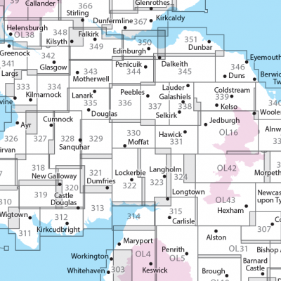
OSI Explorer & Explorer Active - Zuid Scotisch Borders
OSI Explorer & Explorer Active - Zuid Scotisch Borders

Producten op de overzichtskaart
Klik op een product om naar de detailpagina te gaan.
- Wandelkaart 307 Consett & Derwent reservoir - OSI
- Wandelkaart 308 Durham & Sunderland - England - OSI
- Wandelkaart 309 Stranraer & The Rhins - Dumfries - OSI
- Wandelkaart 310 Glenluce & Kirkcowan - Schotland - OSI
- Wandelkaart 311 Wigtown- Whithorn & The Machars - OSI
- Wandelkaart 312 Kirkcudbright & Castle Douglas - OSI
- Wandelkaart 313 Dumfries & Dalbeattie- Schotland - OSI
- Wandelkaart 314 Solway Firth- Wigton & Silloth - OSI
- Wandelkaart 315 Carlisle- Brampton & Longtown - OSI
- Wandelkaart 316 Newcastle upon Tyne - Northumberland - OSI
- Wandelkaart 318 Galloway Forest Park North- Ayrshire
- Wandelkaart 319 Galloway Forest Park South - OSI
- Wandelkaart 320 Castle Douglas & Loch Ken - OSI
- Wandelkaart 321 Nithsdale & Dumfries & Thornhill - OSI
- Wandelkaart 322 Annandale- Dumfries & Galoway - OSI
- Wandelkaart 323 Eskdale & Castle O'er Forest- Schotland - OSI
- Wandelkaart 324 Liddesdale & Kershope Forest - OSI
- Wandelkaart 325 Morpeth & Blyth - Northumberland - OSI
- Wandelkaart 326 Ayr & Troon - South Ayrshire - OSI
- Wandelkaart 327 Cumnock & Dalmellington - OSI
- Wandelkaart 328 Sanquhar & New Cumnock - OSI
- Wandelkaart 329 Lowther Hills- Sanquhar & Leadhills - OSI
- Wandelkaart 330 Moffat & St Mary's Loch - Dumfries - OSI
- Wandelkaart 331 Teviotdale South - Schotisch Borders - OSI
- Wandelkaart 332 Alnwick Amble - Northumberland - OSI
- Wandelkaart 333 Kilmarnock & Irvine - East Ayrshire - OSI
- Wandelkaart 334 East Kilbride- Galston & Darvel - Glasgow - OSI
- Wandelkaart 335 Lanark & Tinto Hills - South Lankashire - OSI
- Wandelkaart 336 Biggar & Broughton - South Lanarkshire - OSI
- Wandelkaart 337 Peebles & Interleithen - Schotish Borders - OSI
- Wandelkaart 338 Galashiels- Selkirk & Melrose - OSI
- Wandelkaart 339 Kelso- Coldstream & Lower Tweed Valley - OSI
- Wandelkaart 340 Holy Island & Bamburgh - OSO
- Wandelkaart 341 Greenock- Largs & Millport - OSI
- Wandelkaart 342 Glasgow Schotland - OSI
- Wandelkaart 343 Motherwell & Coatbridge- Glasgow - OSI
- Wandelkaart 344 Pentland Hills RP- Edinburgh - OSI
- Wandelkaart 345 Lammermuir Hills - Edinburgh - OSI
- Wandelkaart 346 Berwick-upon-Tweed - Northumberland - OSI
- Wandelkaart 349 Falkirk- Cumbernauld & Livingston - OSI
- Wandelkaart 350 Edinburgh - East Schotland - OSI
- Wandelkaart 351 Dunbar & North Berwick - Edinburgh - OSI
- Wandelkaart 361 Isle of Arran - OSI
- Wandelkaart 362 Cowal West & Isle of Bute - OSI
- Wandelkaart OL04 English Lakes - North Western area - OS
- Wandelkaart OL05 English Lakes - North Eastern area - OS
- Wandelkaart OL16 Cheviot Hills, Jedburgh & Wooler - OS
- Wandelkaart OL37 Cowal East- Dunoon & Iverary - OS
- Wandelkaart OL38 Loch Lomond South & Dumbarton - OSI
- Wandelkaart OL42 Kielder Water & Forest - OS
- Wandelkaart OL43 Hadrian's Wall- Haltwhistle & Hexham - OS

OSI Explorer & Explorer Active - Noord Schotland & The Cairngorms
OSI Explorer & Explorer Active - Noord Schotland & The Cairngorms
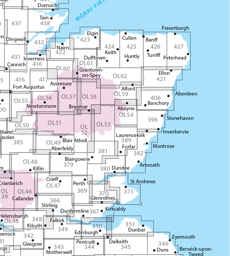
Producten op de overzichtskaart
Klik op een product om naar de detailpagina te gaan.
- Wandelkaart 342 Glasgow Schotland - OSI
- Wandelkaart 348 Campsie Fells- Glasgow - Schotland - OSI
- Wandelkaart 349 Falkirk- Cumbernauld & Livingston - OSI
- Wandelkaart 350 Edinburgh - East Schotland - OSI
- Wandelkaart 351 Dunbar & North Berwick - Edinburgh - OSI
- Wandelkaart 366 Stirling & Ochil Hills West - OSI
- Wandelkaart 367 Dunfermline- Kirkcaldy & Glenrothes - OSI
- Wandelkaart 369 Perth & Kinross - Schotland - OSI
- Wandelkaart 370 Glenrothes North- Falkland & Lomond Hills - OSI
- Wandelkaart 371 St-Andrews & East Fife- Schotland - OSI
- Wandelkaart 379 Dunkeld & Aberfeldy- Glen Almond - OSI
- Wandelkaart 380 Dundee & Sidlaw Hills- Fife - OSI
- Wandelkaart 381 Blairgowrie & Kirriemuir - OSI
- Wandelkaart 382 Arbroath- Montrose & Carnoustie - OSI
- Wandelkaart 385 Rannoch Moor & Ben Alder- Highland's - OSI
- Wandelkaart 389 Forfar- Brechin & Edzell- Tayside - OSI
- Wandelkaart 396 Stoneheaven- Inverbervie & Laurencekirk - OSI
- Wandelkaart 406 Aberdeen & Banchory- Schotland - OSI
- Wandelkaart 416 Inverness & Loch Ness - OSI
- Wandelkaart 417 Monadhliath Mountains North - OSI
- Wandelkaart 421 -llon & Inverurie- Aberdeenshire - OSI
- Wandelkaart 422 Nairn & Cawdor- Inverness - OSI
- Wandelkaart 423 Elgin- Forres & Lossiemouth - OSI
- Wandelkaart 424 Buckie & Keith- Granpian - OSI
- Wandelkaart 425 Huntly & Cullen- Aberdeenshire - OSI
- Wandelkaart 426 Banff- Macduff & Turriff- Aberdeenshire - OSI
- Wandelkaart 427 Peterhead & Fraserburgh- Aberdeenshire - OSI
- Wandelkaart 431Glen Urquhart & Strathglass - OSI
- Wandelkaart 432 Black Isle & Munlochy - OSI
- Wandelkaart OL38 Loch Lomond South & Dumbarton - OSI
- Wandelkaart OL39 Loch Lomond North & Tyndrum - OS
- Wandelkaart OL46 Trossachs NP, Callander & Aberfoyle - OS
- Wandelkaart OL47 Crieff, Comrie & Glen Artney - OS
- Wandelkaart OL49 Pitlorchry & Loch Tummel & Aberfeldy - OS
- Wandelkaart OL50 Ben Alder, Loch Ericht & Laggan - OS
- Wandelkaart OL51 Atholl, Glen Tilt & Beinn Dearg - OS
- Wandelkaart OL52 Glen Shee, Braemar & Cairnwell - OS
- Wandelkaart OL53 Lochnagar, Glen Muick & Glen Clova - OS
- Wandelkaart OL54 Glen Esk, Glen Tanar & Aboyne - OS
- Wandelkaart OL55 Loch Laggan, Creag Meagaidh & Corrieyairack - OS
- Wandelkaart OL56 Badenoch, Upper Strathspey & Kingussie - OS
- Wandelkaart OL57 Cairn Gorm, Aviemore & Loch Morlich - OS
- Wandelkaart OL58 Braemar, Tomintoul & Glen Avon - OS
- Wandelkaart OL59 Aboyne, Alford & Strathdon - OS
- Wandelkaart OL60 Lochindorb & Grantown-on-Spey - OS
- Wandelkaart OL61 Grantown-on-Spey & Hills Cromdale - OS
- Wandelkaart OL62 Correen Hills, Glenlivet & Bennachie - OS
Artikelen uit dezelfde regio

Wandelkaart 360 Loch Awe & Inveraray- Argyl Schotland- OSI • 9780319246115
Wandelkaart Loch Awe & Inveraray - Argyl Schotland Productbeschrijving: Kaart nummer 360 in de OS Explorer kaarten reeks is ideaal voor het ontdekken van de streek rond Loch Awe en Loch Fyne. Dit deel van Argyll and Bute heeft veel prachtige landschappen te verkennen in detail, samen met vele kleinere Lochs en bergtoppen. Andere hoogtepunten van het gebied zijn: Inveraray, Furnace, Dalavic…
Wandelkaart 49 Oban & East Mull- Argyl & Bute Schotland - OSI • 9780319473726
Wandelkaart Oban & East Mull - Argyl & Bute Schotland Productbeschrijving: Oban, is de zeevruchten hoofdstad van Schotland, en is een bloeiend vissersdorpje die veel te bieden heeft. Bezoekers kunnen zien dat de Array van de plaatselijke fauna per boot bereikbaar is, of via in het Schotse Sealife heiligdom op het eiland Mull. Het bergachtige terrein biedt fantastische wandel mogelijkheden …

Wandelkaart 50 Glen Orchy & Loch Etive- Schotland - OSI • 9780319261484
Wandelkaart Glen Orchy & Loch Etive - Scotland Productbeschrijving: Kaart nummer 50 in de OS Landranger kaart serie is de ideale kaart voor het verkennen van het noorden van Loch Fyne Black Mount. Deze kaart dekt een deel van Loch Lomond and The Trossachs National Park en een deel van de West highland way door Glen Orchy en Loch Etvie naar het westen. De OS Landranger kaarten reeks hee…
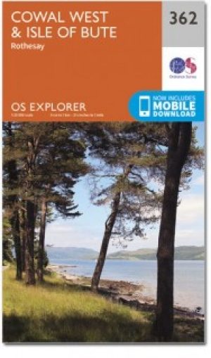
Wandelkaart 362 Cowal West & Isle of Bute- Argyl & Bure • 9780319472330
Wandelkaart Cowal West & Isle of Bute - Argyl & Bute Schotland Omvat ook: Rothesay. Productbeschrijving: Kaart nummer 362 omvat Cowal West, Rothesay en the Isle of Bute. Hoogtepunten zijn Kyles of Bute, Loch Riddon en Loch Lomond en de Trossarchs National Park. Omvat ook Loch Fyne, Garbhallt en Kingarth. De OS Explorer kaart voor Cowal West & Isle of Bute is beschikbaar in zowel de sta…

Wandelgids 031 Pathfinder guides Oban, Mull & Kintyre - OS • 9780319091036
Wandelgids Oban, Mull & Kintyre - OS Productomschrijving: This Pathfinder walking route guidebook for Oban, Mull and Kintyre has 28 circular, graded walks created by experienced seasoned walkers. The routes range from extended strolls of two miles (3.2km) to exhilarating hikes of 13 miles (21km), so there is something for people of all abilities. Key routes in this book include Campbel…