
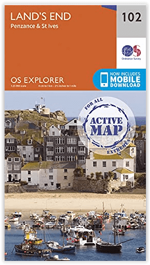
Wandelkaart 102 Land's End - OSI
Penzance - Land's End - Mousehole & Cape Cornwall
Korte omschrijving
Wandelkaart Explorer Active - Land's End - OSI Productomschrijving: Kaart nummer 102 in de OS Explorer kaartenserie is de perfecte kaart voor het ontdekken van het beroemde gebied rond Land'...

Specificaties
- Uitgever: Ordnance Survey
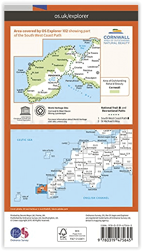
- ISBN-13: 9780319475645
- HOOFDCATEGORIEËN: Wandelkaart
- Activiteiten: Wandelen, Hiking & Trekking
- Regio: Cornwall, England
- Land: England
- Waterafstotende kaart: Ordnance Survey ACTIVE Explorer Weatherproof Maps
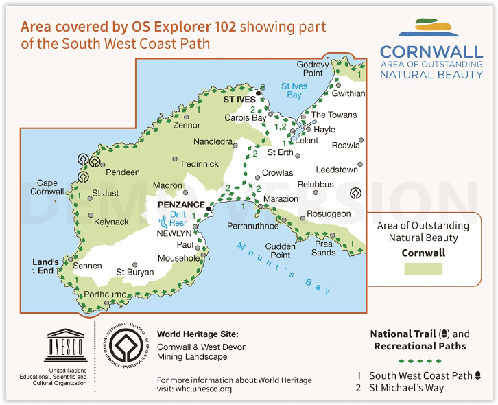
- UNESCO werelderfgoed: Cornwall & West Devon Mining Landscape, England
- AONB - Area of Outstanding Beauty: Cornwall, AONB
- Schaal: 1:25000
- Afmeting: 13x24
- Taal: Engels
- Reeks: Explorer ACTIVE
Volledige omschrijving
Wandelkaart Explorer Active - Land's End - OSI
Productomschrijving: Kaart nummer 102 in de OS Explorer kaartenserie is de perfecte kaart voor het ontdekken van het beroemde gebied rond Land's End, Penzance en St Ives. Het gebied staat bekend als het meest extreem zuidwestelijke punt van Groot-Brittannië.
Hoogtepunten zijn: Penzance, Land's End, Mousehole, en Cape Cornwall.
National Trails and recreational paths: South West Coast Path & St Michael's Way
Inclusief mobiele downloadBij deze kaart ontvangt u een code voor gebruik op uw iOS- of Android-smartphone of -tablet. Meer informatie vindt u bij Veelgestelde vragen over mobiel downloaden
Engelse omschrijving: Map sheet number 102 in the OS Explorer map series is the perfect map for discovering the famous area around Land's End, Penzance and St Ives. The area is well known as the most extreme south westerly point in Britain. Highlights include: Penzance, Land's End, Mousehole, and Cape Cornwall.
Includes mobile downloadWith this map you will receive a code for use on your iOS or Android smartphone or tablet. Find our more at Mobile Download FAQ.
Locatie op kaart
Overzichtskaarten

OSI Explorer & Explorer Active - Z.W. England Devon - Cornwall
OSI Explorer & Explorer Active - Z.W. England Devon - Cornwall

Producten op de overzichtskaart
Klik op een product om naar de detailpagina te gaan.
- Wandelkaart 102 Land's End - OSI
- Wandelkaart 102 Land's End - OSI
- Wandelkaart 103 The Lizard- Cornwall England - OSI
- Wandelkaart 103 The Lizard- Cornwall England - OSI
- Wandelkaart 104 Redruth & St Agnes- Cornwall - OSI
- Wandelkaart 104 Redruth & St Agnes- Cornwall - OSI
- Wandelkaart 105 Falmouth & Mevagissey - Cornawall - OSI
- Wandelkaart 105 Falmouth & Mevagissey - Cornawall - OSI
- Wandelkaart 106 Newquay & Padstow - Cornwall - OSI
- Wandelkaart 106 Newquay & Padstow- Cornwall - OSI
- Wandelkaart 107 St-Austell & Liskeard- Cornwall - OSI
- Wandelkaart 107 St-Austell & Liskeard & Fowey- Cornwall - OSI
- Wandelkaart 108 Lower Tamar Valley & Plymouth - OSI
- Wandelkaart 108 Lower Tamer Valley & Plymouth- Cornwall - OSI
- Wandelkaart 109 Bodmin Moor- Cornwal - OSI
- Wandelkaart 109 Bodmin Moor- Cornwal - OSI
- Wandelkaart 111 Bude- Boscastle & Tintagel- Devon - OSI
- Wandelkaart 111 Bude- Boscastle & Tintagel- Devon - OSI
- Wandelkaart 112 Launceston & Holsworthy- Devon - OSI
- Wandelkaart 112 Launceston & Holsworthy- Devon - OSI
- Wandelkaart 113 Okehampton- Devon England - OSI
- Wandelkaart 113 Okehampton- Devon England - OSI
- Wandelkaart 114 Exeter & Exe Valley- Devon - OSI
- Wandelkaart 114 Exeter & Exe Valley- Devon - OSI
- Wandelkaart 115 Exmouth & Sidmouth- Devon - OSI
- Wandelkaart 115 Exmouth & Sidmouth- Devon - OSI
- Wandelkaart 116 Lyme regis & Bridport- Devon - OSI
- Wandelkaart 116 Lyme Regis & Bridport- Dorset - OSI
- Wandelkaart 117 Cerne Abbas & Bere Regis - Dorset - OSI
- Wandelkaart 117 Cerne Abbas & Bere Regis - Dorset - OSI
- Wandelkaart OL15 Purbeck- South Dorset & Poole - OSI
- Wandelkaart 118 Shaftesbury & Cranbourne Chase - OSI
- Wandelkaart 118 Shaftesbury & Cranbourne Chase - OSI
- Wandelkaart 129 Yeovil & Sherborne- Somerset - OSI
- Wandelkaart 129 Yeovil & Sherborne- Somerset - OSI
- Wandelkaart 140 Quantock Hills AONB & Bridgwater- Devon - OSI
- Wandelkaart 140 Quantock Hills AONB- Somerset - OSI
- Wandelkaart 141 Cheddar Gorge & Mendip Hills - OSI
- Wandelkaart 141Shepton Mallet & Mendip Hills East - OSI
- Wandelkaart 142 Shepton Mallet & Mendip Hills - OSI
- Wandelkaart 142 Shepton Mallet & Mendip Hills - OSI
- Wandelkaart 143 Warminster & Trowbridge- Wiltshire - OSI
- Wandelkaart 143 Warminster & Trowbridge- Wiltshire - OSI
- Wandelkaart 130 Salisburry & Stonehenge- Wiltshire - OSI
- Wandelkaart 130 Salisburry & Stonehenge- Wiltshire - OSI
- Wandelkaart 131 Romsey- Andover & Test Valley- Hampshire
- Wandelkaart 131 Romsey & Andover - Hampshire - OSI
- Wandelkaart 153 Weston-super-Mare & Bleadon Hill - OSI
- Wandelkaart 153 Weston-Super-Mare & Bleadon Hill - OSI
- Wandelkaart 154 Bristol West & Portishead- Bristol - OSI
- Wandelkaart 154 Bristol West & Portishead- Bristol area
- Wandelkaart 155 Bristol & Bath Keynsham & Marshfield - OSI
- Wandelkaart 155 Bristol & Bath- Bristol Area - OSI
- Wandelkaart 156 Chippenham & Bradford-on-Avon - OSI
- Wandelkaart 156 Chippenham & Bradford-on-Avon- Wiltshire - OSI
- Wandelkaart 157 Marlborough & Savernake Forest - OSI
- Wandelkaart 157 Marlborough & Savernake Forest - OSI
- Wandelkaart 158 Newbury & Hungerford- Berkshire - OSI
- Wandelkaart 158 Newbury & Hungerford- West Berkshire - OSI
- Wandelkaart 167 Thornbury- Dursley & Yate - England- OSI
- Wandelkaart 167 Thornbury- Dursley & Yate - England- OSI
- Wandelkaart 168 Stroud- Tetbury & Malmesbury - OSI
- Wandelkaart 168 Stroud- Tetbury & Malmesbury - OSI
- Wandelkaart 169 Cirencester & Swindon - England - OSI
- Wandelkaart 169 Cirencester & Swindon - England - OSI
- Wandelkaart 170 Abingdon & Wantage - Oxfordshire - OSI
- Wandelkaart 170 Abingdon- Wantage & Vale - OSI
- Wandelkaart 179 Gloucester- Cheltenham & Stroud - OSI
- Wandelkaart 179 Gloucester- Cheltenham & Stroud - OSI
- Wandelkaart OL45 The Cotswolds AONB- Gloucestershire - OSI
- Wandelkaart 190 Malvern Hills AONB & Bredon Hill - OSI
- Wandelkaart 190 Malvern Hills AONB & Bredon Hill - OSI
- Wandelkaart 205 Stratford-upon-Avon & Evesham - OSI
- Wandelkaart 205 Stratford-upon-Avon & Evesham - OSI
- Wandelkaart 206 Edge Hill & Fenny Compton - OSI
- Wandelkaart 206 Edge Hill & Fenny Compton - OSI
Artikelen uit dezelfde regio

Wandelkaart 108 Lower Tamer Valley & Plymouth- Cornwall - OSI • 9780319469897
Wandelkaart Lower Tamer Valley & Plymouth - Cornwall England Productbeschrijving: Kaart nummer 108 in de OS Explorer kaarten reeks heeft betrekking op het zuidelijke kust gebied tussen Devon en Cornwall rond Plymouth. Samen met een deel van het Dartmoor National Park en de gebieden van uitstekende natuurlijke schoonheid van Cornwall, Zuid-Devon en de Tamar vallei AONB. zijn dit gebieden wa…

Toeristische kaart Cornwall England - Goldeneye • 9781859652886
Toeristische wandelkaart Cornwall - Goldeneye Productomschrijving: De perfecte, en praktische, combinatie van een vrijetijdskaart en een reisgids die u laat zien waar u heen gaat en waar u vandaan komt, zodat u een beter beeld krijgt van uw reizen - vitale informatie die niet beschikbaar is op GOS, satellietnavigatie iPhones en dergelijke! Engelse omschrijving: The perfect, and practi…

Reisgids Cornwall's Top 10 - Goldeneye • 9781859652510
Cornwall's Top 10 - Goldeneye Productomschrijving: Cornwall, het einde van het Engelse landschap zeg maar, het mekka voor de gepensioneerde levensgenieter, die houden van wandelen, praatjes maken en terrasjes doen. Cornwall biedt een waaier aan activiteiten voor wandelaars, met honderden wandelroutes van formaat. •2nd Edition •112 Pages •100mm x 190mm •Pocket Size •Matt Laminat…

Reisgids Exploring Cornwall - Goldeneye • 9781859652978
Exploring Cornwall - Goldeneye Productomschrijving: Dit boek is anders. Het is een onafhankelijke stem, omdat alle inzendingen worden gekozen op verdienste, en verdienste, alleen. In een digitaal tijdperk waar (reis)informatie wordt verstrekt door reclamebudgetten. Hierbij een verfrissende en verhelderende kijk op wat Cornwall de bezoeker en inwoner te bieden heeft. Engelse omschrijvin…

Wandelgids The South West Coast Path - Cicerone Press • 9781786310682
The South West Coast Path - Cicerone Productomschrijving: Omvat spectaculaire plaatsen die dit deel van het Engelse landschap rijk is, zoals Exmoor National Park, met 5 AONB's of Areas of Outstanding Natural Beauty, de Jurassic Coast Natural World Heritage Site. Deze route bestaat al heel lang. De route start of eindigd natuurlijk in Minehead, in Somerset, loopt langs de kust richting de v…