
Wandelkaart 103 The Lizard- Cornwall England - OSI
Omvat The Lizard- Falmouth en Helston

Korte omschrijving
Wandelkaart The Lizard - Cornwall England - OSI Productbeschrijving: Kaart nummer 103 in de OS Explorer kaarten reeks is de ideale kaart voor het verkennen van The Lizard, Falmouth en Helsto...

Specificaties
- Uitgever: Ordnance Survey
- ISBN-13: 9780319469842
- HOOFDCATEGORIEËN: Wandelkaart
- Activiteiten: Wandelen, Hiking & Trekking
- Regio: Cornwall, England
- Land: England
- Waterafstotende kaart: Ordnance Survey ACTIVE Explorer Weatherproof Maps
- AONB - Area of Outstanding Beauty: Cornwall, AONB
- Schaal: 1:25000
- Afmeting: 13x24
- Taal: Engels
- Reeks: Explorer ACTIVE
Volledige omschrijving
Wandelkaart The Lizard - Cornwall England - OSI
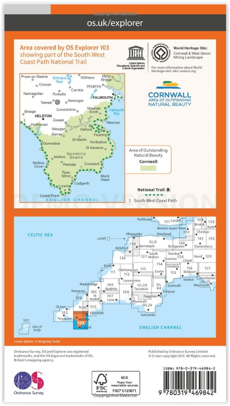
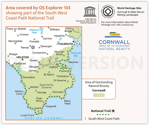
Productbeschrijving: Kaart nummer 103 in de OS Explorer kaarten reeks is de ideale kaart voor het verkennen van The Lizard, Falmouth en Helston. Hoogtepunten van het gebied zijn onder meer: Falmouth, Goonhilly Downs, Mullion Cove, Lizard Point, Bumble Rock, Cornwall Maritime Museum, Porthleven en de South West Coast Path. De OS Explorer kaart voor The Lizard is beschikbaar in zowel de standaard papieren versie als de weerbestendige 'Actief' versie.
National trail: Sout West Coast Path. - AONB: Corwall
Productdiscription: Map sheet number 103 in the OS Explorer map series is the ideal map for exploring The Lizard, Falmouth and Helston. Highlights of the area include: Falmouth, Goonhilly Downs, Mullion Cove, Lizard Point, Bumble Rock, Cornwall Maritime Museum, Porthleven and the South West Coast Path. The OS Explorer map for The Lizard is available in both the standard paper version and weatherproof 'Active' version.
Locatie op kaart
Gekoppelde artikelen

Wandelkaart 103 The Lizard Cornwall England - OSI • 9780319243053
standaard versieWandelkaart The Lizard - South west England - OSI Omvat ook: Falmouth & Helston. Productbeschrijving: Kaart nummer 103 in de OS Explorer kaarten reeks is de ideale kaart voor het verkennen van The Lizard, Falmouth en Helston. Hoogtepunten van het gebied zijn onder andere: Falmouth, Goonhilly Downs, Mullion Cove, Lizard Point, Bumble Rock, Cornwall Maritime Museum, Porthleven en de Sout…

Wandelkaart 103 The Lizard- Cornwall England - OSI • 9780319469842
weatherproof versieWandelkaart The Lizard - Cornwall England - OSI Productbeschrijving: Kaart nummer 103 in de OS Explorer kaarten reeks is de ideale kaart voor het verkennen van The Lizard, Falmouth en Helston. Hoogtepunten van het gebied zijn onder meer: Falmouth, Goonhilly Downs, Mullion Cove, Lizard Point, Bumble Rock, Cornwall Maritime Museum, Porthleven en de South West Coast Path. De OS Explorer kaart…
Overzichtskaarten

OSI Explorer & Explorer Active - Z.W. England Devon - Cornwall
OSI Explorer & Explorer Active - Z.W. England Devon - Cornwall

Producten op de overzichtskaart
Klik op een product om naar de detailpagina te gaan.
- Wandelkaart 102 Land's End - OSI
- Wandelkaart 102 Land's End - OSI
- Wandelkaart 103 The Lizard- Cornwall England - OSI
- Wandelkaart 103 The Lizard- Cornwall England - OSI
- Wandelkaart 104 Redruth & St Agnes- Cornwall - OSI
- Wandelkaart 104 Redruth & St Agnes- Cornwall - OSI
- Wandelkaart 105 Falmouth & Mevagissey - Cornawall - OSI
- Wandelkaart 105 Falmouth & Mevagissey - Cornawall - OSI
- Wandelkaart 106 Newquay & Padstow - Cornwall - OSI
- Wandelkaart 106 Newquay & Padstow- Cornwall - OSI
- Wandelkaart 107 St-Austell & Liskeard- Cornwall - OSI
- Wandelkaart 107 St-Austell & Liskeard & Fowey- Cornwall - OSI
- Wandelkaart 108 Lower Tamar Valley & Plymouth - OSI
- Wandelkaart 108 Lower Tamer Valley & Plymouth- Cornwall - OSI
- Wandelkaart 109 Bodmin Moor- Cornwal - OSI
- Wandelkaart 109 Bodmin Moor- Cornwal - OSI
- Wandelkaart 111 Bude- Boscastle & Tintagel- Devon - OSI
- Wandelkaart 111 Bude- Boscastle & Tintagel- Devon - OSI
- Wandelkaart 112 Launceston & Holsworthy- Devon - OSI
- Wandelkaart 112 Launceston & Holsworthy- Devon - OSI
- Wandelkaart 113 Okehampton- Devon England - OSI
- Wandelkaart 113 Okehampton- Devon England - OSI
- Wandelkaart 114 Exeter & Exe Valley- Devon - OSI
- Wandelkaart 114 Exeter & Exe Valley- Devon - OSI
- Wandelkaart 115 Exmouth & Sidmouth- Devon - OSI
- Wandelkaart 115 Exmouth & Sidmouth- Devon - OSI
- Wandelkaart 116 Lyme regis & Bridport- Devon - OSI
- Wandelkaart 116 Lyme Regis & Bridport- Dorset - OSI
- Wandelkaart 117 Cerne Abbas & Bere Regis - Dorset - OSI
- Wandelkaart 117 Cerne Abbas & Bere Regis - Dorset - OSI
- Wandelkaart OL15 Purbeck- South Dorset & Poole - OSI
- Wandelkaart 118 Shaftesbury & Cranbourne Chase - OSI
- Wandelkaart 118 Shaftesbury & Cranbourne Chase - OSI
- Wandelkaart 129 Yeovil & Sherborne- Somerset - OSI
- Wandelkaart 129 Yeovil & Sherborne- Somerset - OSI
- Wandelkaart 140 Quantock Hills AONB & Bridgwater- Devon - OSI
- Wandelkaart 140 Quantock Hills AONB- Somerset - OSI
- Wandelkaart 141 Cheddar Gorge & Mendip Hills - OSI
- Wandelkaart 141Shepton Mallet & Mendip Hills East - OSI
- Wandelkaart 142 Shepton Mallet & Mendip Hills - OSI
- Wandelkaart 142 Shepton Mallet & Mendip Hills - OSI
- Wandelkaart 143 Warminster & Trowbridge- Wiltshire - OSI
- Wandelkaart 143 Warminster & Trowbridge- Wiltshire - OSI
- Wandelkaart 130 Salisburry & Stonehenge- Wiltshire - OSI
- Wandelkaart 130 Salisburry & Stonehenge- Wiltshire - OSI
- Wandelkaart 131 Romsey- Andover & Test Valley- Hampshire
- Wandelkaart 131 Romsey & Andover - Hampshire - OSI
- Wandelkaart 153 Weston-super-Mare & Bleadon Hill - OSI
- Wandelkaart 153 Weston-Super-Mare & Bleadon Hill - OSI
- Wandelkaart 154 Bristol West & Portishead- Bristol - OSI
- Wandelkaart 154 Bristol West & Portishead- Bristol area
- Wandelkaart 155 Bristol & Bath Keynsham & Marshfield - OSI
- Wandelkaart 155 Bristol & Bath- Bristol Area - OSI
- Wandelkaart 156 Chippenham & Bradford-on-Avon - OSI
- Wandelkaart 156 Chippenham & Bradford-on-Avon- Wiltshire - OSI
- Wandelkaart 157 Marlborough & Savernake Forest - OSI
- Wandelkaart 157 Marlborough & Savernake Forest - OSI
- Wandelkaart 158 Newbury & Hungerford- Berkshire - OSI
- Wandelkaart 158 Newbury & Hungerford- West Berkshire - OSI
- Wandelkaart 167 Thornbury- Dursley & Yate - England- OSI
- Wandelkaart 167 Thornbury- Dursley & Yate - England- OSI
- Wandelkaart 168 Stroud- Tetbury & Malmesbury - OSI
- Wandelkaart 168 Stroud- Tetbury & Malmesbury - OSI
- Wandelkaart 169 Cirencester & Swindon - England - OSI
- Wandelkaart 169 Cirencester & Swindon - England - OSI
- Wandelkaart 170 Abingdon & Wantage - Oxfordshire - OSI
- Wandelkaart 170 Abingdon- Wantage & Vale - OSI
- Wandelkaart 179 Gloucester- Cheltenham & Stroud - OSI
- Wandelkaart 179 Gloucester- Cheltenham & Stroud - OSI
- Wandelkaart OL45 The Cotswolds AONB- Gloucestershire - OSI
- Wandelkaart 190 Malvern Hills AONB & Bredon Hill - OSI
- Wandelkaart 190 Malvern Hills AONB & Bredon Hill - OSI
- Wandelkaart 205 Stratford-upon-Avon & Evesham - OSI
- Wandelkaart 205 Stratford-upon-Avon & Evesham - OSI
- Wandelkaart 206 Edge Hill & Fenny Compton - OSI
- Wandelkaart 206 Edge Hill & Fenny Compton - OSI
Artikelen uit dezelfde regio

Wandelkaart South West Coast Path 3 - Harvey Maps • 9781851376834
South West Coast Path - Harvey Maps Productomschrijving: Het South West Coast path is een dikke 1014 km lang en omvat het volledige South-West-England met daarin Devon & Corwall. Het pad is een National trail en behoort tot de langste routes van Engeland. De route start in Minehead in Somerset en loopt de volledige kust af tot in Poole in Dorset. OPGELET: deze kaart omvat het laatste deel …

Wandelkaart 1 Cornwall Zuidwest Engeland - K&F • 9783828308497
Wandelkaart - Cornwall Zuidwest Engeland - K&F Productomschrijving: Cornwall, het uitsteeksel van Zuid-West Engeland. De plaats waar zo vele Engelsen hun vakantie willen doorbrengen aan zee. De regio staat bekend voor zijn machtige strandwandelingen. De routes zijn uitgestippeld ter plaatse, en deze wandelkaart bied u de mogelijkheid om al de rest van de omgelegen info te wete te komen. Oo…

Wandelkaart 190 Bude & Clovelly Cornwall England - OSI • 9780319262887
Wandelkaart Bude & Clovelly - Cornwall England Productbeschrijving: Kaart nummer 190 in de OS Landranger kaarten reeks, is de ideale kaart om te gebruiken bij het plannen van een reis naar Bude, Clovelly en Boscastle Holsworthy. Het gebied is zeer geschikt voor kustactiviteiten zoals de surfen of zee kajakken en biedt vele mogelijkheden voor sightseeing. Andere hoogtepunten zijn: Widemouth…

Wandelkaart 109 Bodmin Moor Cornwal - OSI • 9780319243114
Wandelkaart Bodmin Moor - Cornwal - Ordnance Survey Productomschrijving: - Bodmin, Camelford & Liskeard. 109 / Bodmin Moor, Cornwal, England - Neem de steden van Liskeard, Bodmin en Camelford, waarvan deze kaart dekking biedt van Bodmin Moor alsmede een deel van de National Trail de South West Coast Path. De OS Explorer kaart voor Bodmin Moor is beschikbaar in zowel de standaard papier…

Wandelkaart 105 Falmouth & Mevagissey Cornwall - OSI • 9780319243077
Wandelkaart Falmouth & Mevagissey - Cornwall - Ordnance Survey Productbeschrijving: - Truro & St Mawes. 105 / Falmouth & Mevagissey, Cornwall, England - Kaart nummer 105 in de OS Explorer kaarten reeks is de ideale kaart om te wandelen en te fietsen rond Falmouth, St Mawes, Lochristi en Truro. De South West Coast Path is een ideale manier om de kustlijn in dit deel van Cornwall te verk…