

Wandelkaart 153 Weston-super-Mare & Bleadon Hill - OSI
Omvat Weston-super-Mare- Clevedon & Burnham-on-Sea

Korte omschrijving
Wandelkaarten Somerset South West England van Ordnance Survey. Ideaal voor tochten in England.
Wandelkaart Weston-super-Mare & Bleadon - North Somerset Omvat ook: Burnham-on-Sea & Clevedon Productbeschrijving: Kaart nummer 153 omvat Weston-super-Mare, Clevedon en Burnham-on-Sea. H...

Specificaties
- Uitgever: Ordnance Survey
- ISBN-13: 9780319243466
- HOOFDCATEGORIEËN: Wandelkaart
- Activiteiten: Wandelen, Hiking & Trekking
- Regio: Somerset South West England
- Land: England
- TOPO's & Stafkaarten: Topografisch wandelen
- Schaal: 1:25000
- Taal: Engels
- Reeks/Serie: Explorer Series OS
Volledige omschrijving
Wandelkaart Weston-super-Mare & Bleadon - North Somerset
Omvat ook: Burnham-on-Sea & Clevedon
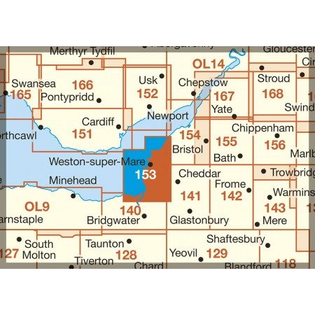
Productbeschrijving: Kaart nummer 153 omvat Weston-super-Mare, Clevedon en Burnham-on-Sea. Hoogtepunten zijn Mendip Hills, Bleadon Hill, Gordano Round en River Parrett Trail. Omvat ook Highbridge en de rivieren Yeo, Axe en Brue. De OS Explorer kaart voor Weston-super-Mare & Bleadon Hill is beschikbaar in zowel de standaard papieren versie als de weerbestendige 'Actief' versie
Productdiscription: Map sheet number 153 covers Weston-super-Mare, Clevedon and Burnham-on-Sea. Highlights include Mendip Hills, Bleadon Hill, Gordano Round and River Parrett Trail. Also includes Highbridge and the rivers Yeo, Axe and Brue. The OS Explorer map for Weston-super-Mare & Bleadon Hill is available in both the standard paper version and weatherproof 'Active' version.
Locatie op kaart
Gekoppelde artikelen

Wandelkaart 153 Weston-super-Mare & Bleadon Hill - OSI • 9780319243466
standaard versieWandelkaart Weston-super-Mare & Bleadon - North Somerset Omvat ook: Burnham-on-Sea & Clevedon Productbeschrijving: Kaart nummer 153 omvat Weston-super-Mare, Clevedon en Burnham-on-Sea. Hoogtepunten zijn Mendip Hills, Bleadon Hill, Gordano Round en River Parrett Trail. Omvat ook Highbridge en de rivieren Yeo, Axe en Brue. De OS Explorer kaart voor Weston-super-Mare & Bleadon Hill is bes…

Wandelkaart 153 Weston-Super-Mare & Bleadon Hill - OSI • 9780319470251
weatherproof versieWandelkaart Weston-Super-Mare & Bleadon Hill - Sutton England Omvat ook: Burnham-on-Sea & Clevedon Productbeschrijving: Kaart nummer 153 omvat Weston-super-Mare, Clevedon en Burnham-on-Sea. Hoogtepunten zijn Mendip Hills AONB, Bleadon Hill, Gordano ronde en River Parrett Trail. Omvat ook Highbridge en de rivieren Yeo, Axe en Brue. De OS Explorer kaart voor Weston-super-Mare & Bleadon H…
Overzichtskaarten

OSI Explorer & Explorer Active - Z.W. England Devon - Cornwall
OSI Explorer & Explorer Active - Z.W. England Devon - Cornwall

Producten op de overzichtskaart
Klik op een product om naar de detailpagina te gaan.
- Wandelkaart 102 Land's End - OSI
- Wandelkaart 102 Land's End - OSI
- Wandelkaart 103 The Lizard- Cornwall England - OSI
- Wandelkaart 103 The Lizard- Cornwall England - OSI
- Wandelkaart 104 Redruth & St Agnes- Cornwall - OSI
- Wandelkaart 104 Redruth & St Agnes- Cornwall - OSI
- Wandelkaart 105 Falmouth & Mevagissey - Cornawall - OSI
- Wandelkaart 106 Newquay & Padstow - Cornwall - OSI
- Wandelkaart 107 St-Austell & Liskeard- Cornwall - OSI
- Wandelkaart 108 Lower Tamar Valley & Plymouth - OSI
- Wandelkaart 109 Bodmin Moor- Cornwal - OSI
- Wandelkaart 111 Bude- Boscastle & Tintagel- Devon - OSI
- Wandelkaart 112 Launceston & Holsworthy- Devon - OSI
- Wandelkaart 113 Okehampton- Devon England - OSI
- Wandelkaart 113 Okehampton- Devon England - OSI
- Wandelkaart 114 Exeter & Exe Valley- Devon - OSI
- Wandelkaart 114 Exeter & Exe Valley- Devon - OSI
- Wandelkaart 115 Exmouth & Sidmouth- Devon - OSI
- Wandelkaart 115 Exmouth & Sidmouth- Devon - OSI
- Wandelkaart 116 Lyme regis & Bridport- Devon - OSI
- Wandelkaart 116 Lyme Regis & Bridport- Dorset - OSI
- Wandelkaart 117 Cerne Abbas & Bere Regis - Dorset - OSI
- Wandelkaart 117 Cerne Abbas & Bere Regis - Dorset - OSI
- Wandelkaart OL15 Purbeck- South Dorset & Poole - OSI
- Wandelkaart 118 Shaftesbury & Cranbourne Chase - OSI
- Wandelkaart 118 Shaftesbury & Cranbourne Chase - OSI
- Wandelkaart 129 Yeovil & Sherborne- Somerset - OSI
- Wandelkaart 129 Yeovil & Sherborne- Somerset - OSI
- Wandelkaart 140 Quantock Hills AONB & Bridgwater- Devon - OSI
- Wandelkaart 140 Quantock Hills AONB- Somerset - OSI
- Wandelkaart 141 Cheddar Gorge & Mendip Hills - OSI
- Wandelkaart 141 Shepton Mallet & Mendip Hills East - OSI
- Wandelkaart 142 Shepton Mallet & Mendip Hills - OSI
- Wandelkaart 142 Shepton Mallet & Mendip Hills - OSI
- Wandelkaart 143 Warminster & Trowbridge- Wiltshire - OSI
- Wandelkaart 143 Warminster & Trowbridge- Wiltshire - OSI
- Wandelkaart 130 Salisburry & Stonehenge- Wiltshire - OSI
- Wandelkaart 130 Salisburry & Stonehenge- Wiltshire - OSI
- Wandelkaart 131 Romsey- Andover & Test Valley- Hampshire
- Wandelkaart 131 Romsey & Andover - Hampshire - OSI
- Wandelkaart 153 Weston-super-Mare & Bleadon Hill - OSI
- Wandelkaart 153 Weston-Super-Mare & Bleadon Hill - OSI
- Wandelkaart 154 Bristol West & Portishead- Bristol - OSI
- Wandelkaart 154 Bristol West & Portishead- Bristol area
- Wandelkaart 155 Bristol & Bath Keynsham & Marshfield - OSI
- Wandelkaart 155 Bristol & Bath- Bristol Area - OSI
- Wandelkaart 156 Chippenham & Bradford-on-Avon - OSI
- Wandelkaart 156 Chippenham & Bradford-on-Avon- Wiltshire - OSI
- Wandelkaart 157 Marlborough & Savernake Forest - OSI
- Wandelkaart 157 Marlborough & Savernake Forest - OSI
- Wandelkaart 158 Newbury & Hungerford- Berkshire - OSI
- Wandelkaart 158 Newbury & Hungerford- West Berkshire - OSI
- Wandelkaart 167 Thornbury- Dursley & Yate - England- OSI
- Wandelkaart 167 Thornbury- Dursley & Yate - England- OSI
- Wandelkaart 168 Stroud- Tetbury & Malmesbury - OSI
- Wandelkaart 168 Stroud- Tetbury & Malmesbury - OSI
- Wandelkaart 169 Cirencester & Swindon - England - OSI
- Wandelkaart 169 Cirencester & Swindon - England - OSI
- Wandelkaart 170 Abingdon & Wantage - Oxfordshire - OSI
- Wandelkaart 170 Abingdon- Wantage & Vale - OSI
- Wandelkaart 179 Gloucester- Cheltenham & Stroud - OSI
- Wandelkaart 205 Stratford-upon-Avon & Evesham - OSI
- Wandelkaart 205 Stratford-upon-Avon & Evesham - OSI
- Wandelkaart 206 Edge Hill & Fenny Compton - OSI
- Wandelkaart 206 Edge Hill & Fenny Compton - OSI
- Wandelkaart OL09 Exmoor NP Devon England - OS
- Wandelkaart OL15 Purbeck & South Dorset - OS
- Wandelkaart OL20 South Devon & Dartmoor NP - OS
- Wandelkaart OL22 New Forest National Park - OS
- Wandelkaart OL28 Dartmoor National Park - OS
- Wandelkaart OL45 The Cotswolds AONB - OS
Artikelen uit dezelfde regio

Wandelkaart 142 Shepton Mallet & Mendip Hills - OSI • 9780319243350
Wandelkaart Shepton Mallet & Mendip Hills East - Somerset Omvat ook: Frome & Midsomer Norton. Productbeschrijving: Kaart nummer 142 in de OS Explorer kaarten reeks omvat Midsomer Norton, Frome, Shepton Mallett en Strauss. Hoogtepunten van het gebied zijn onder andere: Westerse Cranbourne Chase AONB en West Wiltshire Downs AONB, het zuidelijkste puntje van de Cotswolds AONB. De rivier d…

Reisgids Bath- Bristol & Somerset - Rough Guides • 9781839059841
Bath- Bristol & Somerset - Rough Guides Productomschrijving: De regio van somerset in Zuid west Engeland, biedt u in deze gids de uitlopers van Exmoor nationaal park, Bath, Bristol en de volledige regio Somerset. Engelse omschrijving: From the genteel Georgian terraces of Bath to the wilderness expanses of Exmoor NP, the fully updated The Rough Guide to Bath, Bristol & Somerset provide…
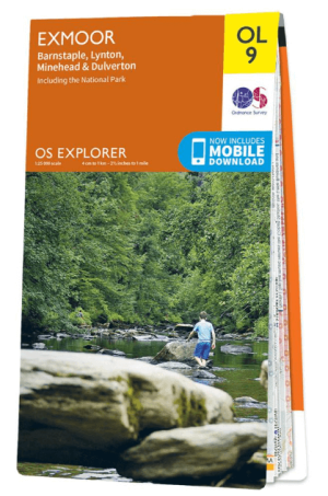
Wandelkaart OL09 Exmoor NP Devon England - OS • 9780319242483
Wandelkaart Exmoor NP Devon England - OS Productomschrijving: Exmoor National Park, Devon England Omvat: Exmoor National Park, Devon England, Barnstaple, Lynton, Minehead & Dulverton. Ontdek de OL-serie van Ordnance Survey: De OL-serie (Outdoor Leisure) van Ordnance Survey is dé referentie voor wie gaat wandelen op de Britse eilanden. Deze topografische kaarten maken deel uit va…

Wandelkaart 181 Minehead & Brendon Hills- England - OSI • 9780319475041
Wandelkaart Minehead & Brendon Hills - Exmoor NP Somerset Productbeschrijving: De OS Landranger kaarten reeks heeft betrekking op Groot-Brittannië met 204 gedetailleerde kaarten, perfect voor dagtochten en korte pauzes. Elke kaart bevat alle informatie die u nodig heeft om dit lokaal gebied te leren kennen en omvat plaatsen van belang, toeristische informatie, picknickplaatsen en campings,…

Cotswolds Mountain Biking - Vertebrate Publ. • 9781906148140
Cotswolds AONB Mountain Biking - Vertebrate Productomschrijving: 20 Classic Rides - Cotwolds Mountain Biking by Tom Fenton features 20 classic MTB routes in the Cotswold Hills across the counties of Gloucestershire and Oxfordshire, and extending into parts of Wiltshire, Somerset, Worcestershire and Warwickshire. With Ordnance Survey mapping and easy-to-follow directions. The Cotswold H…