

Wandelkaart 103 The Lizard- Cornwall England - OSI
Verken de locaties- The Lizard- Falmouth & Helston


Korte omschrijving
Wandelkaarten South West England van Ordnance Survey. Ideaal voor tochten in England.
Wandelkaart The Lizard - South west England - OSI Omvat ook: Falmouth & Helston. Productbeschrijving: Kaart nummer 103 in de OS Explorer kaarten reeks is de ideale kaart voor het verkenn...

Specificaties
- Uitgever: Ordnance Survey
- ISBN-13: 9780319243053
- HOOFDCATEGORIEËN: Wandelkaart
- Activiteiten: Wandelen, Hiking & Trekking
- Regio: South West England
- Land: England
- TOPO's & Stafkaarten: Topografisch wandelen
- AONB - Area of Outstanding Beauty: Cornwall, AONB
- Schaal: 1:25000
- Taal: Engels
- Reeks/Serie: Explorer Series OS
- De Engelse Graafschappen: Cornwall
Volledige omschrijving
Wandelkaart The Lizard - South west England - OSI
Omvat ook: Falmouth & Helston.
Productbeschrijving: Kaart nummer 103 in de OS Explorer kaarten reeks is de ideale kaart voor het verkennen van The Lizard, Falmouth en Helston. Hoogtepunten van het gebied zijn onder andere: Falmouth, Goonhilly Downs, Mullion Cove, Lizard Point, Bumble Rock, Cornwall Maritime Museum, Porthleven en de South West Coast Path. De OS Explorer kaart voor The Lizard is beschikbaar in zowel de standaard papieren versie als de weerbestendige 'Actief' versie.
National trail: Sout West Coast Path - AONB: Cornwall
Productdiscription: Map sheet number 103 in the OS Explorer map series is the ideal map for exploring The Lizard, Falmouth and Helston. Highlights of the area include: Falmouth, Goonhilly Downs, Mullion Cove, Lizard Point, Bumble Rock, Cornwall Maritime Museum, Porthleven and the South West Coast Path. The OS Explorer map for The Lizard is available in both the standard paper version and weatherproof 'Active' version.

Locatie op kaart
Gekoppelde artikelen

Wandelkaart 103 The Lizard- Cornwall England - OSI • 9780319243053
standaard versieWandelkaart The Lizard - South west England - OSI Omvat ook: Falmouth & Helston. Productbeschrijving: Kaart nummer 103 in de OS Explorer kaarten reeks is de ideale kaart voor het verkennen van The Lizard, Falmouth en Helston. Hoogtepunten van het gebied zijn onder andere: Falmouth, Goonhilly Downs, Mullion Cove, Lizard Point, Bumble Rock, Cornwall Maritime Museum, Porthleven en de Sout…

Wandelkaart 103 The Lizard- Cornwall England - OSI • 9780319469842
weatherproof versieWandelkaart The Lizard - Cornwall England - OSI Productbeschrijving: Kaart nummer 103 in de OS Explorer kaarten reeks is de ideale kaart voor het verkennen van The Lizard, Falmouth en Helston. Hoogtepunten van het gebied zijn onder meer: Falmouth, Goonhilly Downs, Mullion Cove, Lizard Point, Bumble Rock, Cornwall Maritime Museum, Porthleven en de South West Coast Path. De OS Explorer kaart…
Overzichtskaarten

OSI Explorer & Explorer Active - Z.W. England Devon - Cornwall
OSI Explorer & Explorer Active - Z.W. England Devon - Cornwall

Producten op de overzichtskaart
Klik op een product om naar de detailpagina te gaan.
- Wandelkaart 102 Land's End - OSI
- Wandelkaart 102 Land's End - OSI
- Wandelkaart 103 The Lizard- Cornwall England - OSI
- Wandelkaart 103 The Lizard- Cornwall England - OSI
- Wandelkaart 104 Redruth & St Agnes- Cornwall - OSI
- Wandelkaart 104 Redruth & St Agnes- Cornwall - OSI
- Wandelkaart 105 Falmouth & Mevagissey - Cornawall - OSI
- Wandelkaart 106 Newquay & Padstow - Cornwall - OSI
- Wandelkaart 107 St-Austell & Liskeard- Cornwall - OSI
- Wandelkaart 108 Lower Tamar Valley & Plymouth - OSI
- Wandelkaart 109 Bodmin Moor- Cornwal - OSI
- Wandelkaart 111 Bude- Boscastle & Tintagel- Devon - OSI
- Wandelkaart 112 Launceston & Holsworthy- Devon - OSI
- Wandelkaart 113 Okehampton- Devon England - OSI
- Wandelkaart 113 Okehampton- Devon England - OSI
- Wandelkaart 114 Exeter & Exe Valley- Devon - OSI
- Wandelkaart 114 Exeter & Exe Valley- Devon - OSI
- Wandelkaart 115 Exmouth & Sidmouth- Devon - OSI
- Wandelkaart 115 Exmouth & Sidmouth- Devon - OSI
- Wandelkaart 116 Lyme regis & Bridport- Devon - OSI
- Wandelkaart 116 Lyme Regis & Bridport- Dorset - OSI
- Wandelkaart 117 Cerne Abbas & Bere Regis - Dorset - OSI
- Wandelkaart 117 Cerne Abbas & Bere Regis - Dorset - OSI
- Wandelkaart OL15 Purbeck- South Dorset & Poole - OSI
- Wandelkaart 118 Shaftesbury & Cranbourne Chase - OSI
- Wandelkaart 118 Shaftesbury & Cranbourne Chase - OSI
- Wandelkaart 129 Yeovil & Sherborne- Somerset - OSI
- Wandelkaart 129 Yeovil & Sherborne- Somerset - OSI
- Wandelkaart 140 Quantock Hills AONB & Bridgwater- Devon - OSI
- Wandelkaart 140 Quantock Hills AONB- Somerset - OSI
- Wandelkaart 141 Cheddar Gorge & Mendip Hills - OSI
- Wandelkaart 141 Shepton Mallet & Mendip Hills East - OSI
- Wandelkaart 142 Shepton Mallet & Mendip Hills - OSI
- Wandelkaart 142 Shepton Mallet & Mendip Hills - OSI
- Wandelkaart 143 Warminster & Trowbridge- Wiltshire - OSI
- Wandelkaart 143 Warminster & Trowbridge- Wiltshire - OSI
- Wandelkaart 130 Salisburry & Stonehenge- Wiltshire - OSI
- Wandelkaart 130 Salisburry & Stonehenge- Wiltshire - OSI
- Wandelkaart 131 Romsey- Andover & Test Valley- Hampshire
- Wandelkaart 131 Romsey & Andover - Hampshire - OSI
- Wandelkaart 153 Weston-super-Mare & Bleadon Hill - OSI
- Wandelkaart 153 Weston-Super-Mare & Bleadon Hill - OSI
- Wandelkaart 154 Bristol West & Portishead- Bristol - OSI
- Wandelkaart 154 Bristol West & Portishead- Bristol area
- Wandelkaart 155 Bristol & Bath Keynsham & Marshfield - OSI
- Wandelkaart 155 Bristol & Bath- Bristol Area - OSI
- Wandelkaart 156 Chippenham & Bradford-on-Avon - OSI
- Wandelkaart 156 Chippenham & Bradford-on-Avon- Wiltshire - OSI
- Wandelkaart 157 Marlborough & Savernake Forest - OSI
- Wandelkaart 157 Marlborough & Savernake Forest - OSI
- Wandelkaart 158 Newbury & Hungerford- Berkshire - OSI
- Wandelkaart 158 Newbury & Hungerford- West Berkshire - OSI
- Wandelkaart 167 Thornbury- Dursley & Yate - England- OSI
- Wandelkaart 167 Thornbury- Dursley & Yate - England- OSI
- Wandelkaart 168 Stroud- Tetbury & Malmesbury - OSI
- Wandelkaart 168 Stroud- Tetbury & Malmesbury - OSI
- Wandelkaart 169 Cirencester & Swindon - England - OSI
- Wandelkaart 169 Cirencester & Swindon - England - OSI
- Wandelkaart 170 Abingdon & Wantage - Oxfordshire - OSI
- Wandelkaart 170 Abingdon- Wantage & Vale - OSI
- Wandelkaart 179 Gloucester- Cheltenham & Stroud - OSI
- Wandelkaart 205 Stratford-upon-Avon & Evesham - OSI
- Wandelkaart 205 Stratford-upon-Avon & Evesham - OSI
- Wandelkaart 206 Edge Hill & Fenny Compton - OSI
- Wandelkaart 206 Edge Hill & Fenny Compton - OSI
- Wandelkaart OL09 Exmoor NP Devon England - OS
- Wandelkaart OL15 Purbeck & South Dorset - OS
- Wandelkaart OL20 South Devon & Dartmoor NP - OS
- Wandelkaart OL22 New Forest National Park - OS
- Wandelkaart OL28 Dartmoor National Park - OS
- Wandelkaart OL45 The Cotswolds AONB - OS
Artikelen uit dezelfde regio
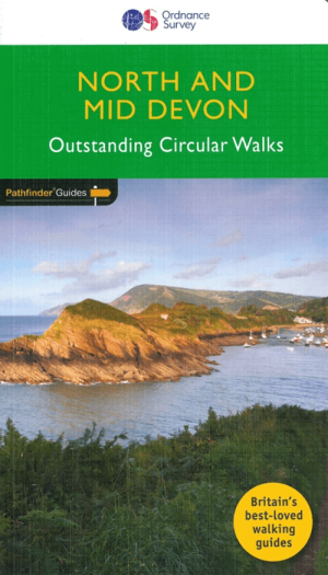
Wandelgids 068 Pathfinder guides Devon North & Mid - OS • 9780319090756
Wandelgids North & Mid Devon - OS Productomschrijving: A must-have for a day trip to North Devon, this Jarrold Pathfinder Guide maps out 28 walks that are ideal for exploring new regions and beautiful scenery. Ideal for planning a weekend walk with the family, this handy walking guide from Jarrold lets you explore with extended strolls and exhilarating hikes for young and old. - Featu…

Wandelgids Part 3 SWCP Map Booklet PLymouth to pool - Cicerone • 9781786312006
Map booklet South West Coast Path - Cicerone Productomschrijving: Kaart van een deel van het zuidelijke deel van het 630 mijl (1014 km) lange South West Coast Path National Trail. Omvat het pad van Plymouth naar Poole langs de kustlijn van Devon en Dorset. Dit handige en compacte boekje met Ordnance Survey 1:25.000 kaarten toont de route en biedt alle kaarten die je nodig hebt om het pad i…

Fietsgids South West England Gravel Rides - Vertebrate Publ. • 9781839812545
South West England Gravel Rides - Vertebrate Publ. Productomschrijving: 24 gravel bike adventures in the West Country Gravel Rides South West England features 24 cycling routes, ranging from 16 to 180 kilometres, showcasing the extensive gravel trails of the West Country. Gravel enthusiast and experienced route creator Katherine Moore has taken her love of the South West and extensive …

Wandelkaart OL15 Purbeck & South Dorset - OS • 9780319242544
Wandelkaart Purbeck & South Dorset - OS Productomschrijving: Parts of the South West Coast Path SWCP, Dorset Area of Outstanding Natural Beauty. Omvat: Purbeck, South Dorset, Poole, Dorchester, Weymouth & Swanage, Castleman Trailway, E9 European Coastal parth, England Coast Path, Hardy Way, Jubilee Trail, Macmillan Way, Monarch's Way, Poole Harbour Trail, Portland Coast Path, Purbeck …
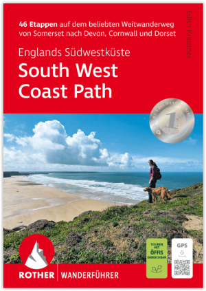
Wandelgids South West Coast Path - Englands Südwestküste - Rother • 9783763348794
Wandelgids South West Coast Path - Rother Productomschrijving: De South West Coast Path – kortweg SWCP – in het zuidwesten van Engeland is de droom van elke langeafstandwandelaar. De route strekt zich uit over meer dan 1000 kilometer langs de spectaculaire kusten van Somerset, Devon, Cornwall en Dorset. Deze route laat u de ruige schoonheid van Engeland ervaren met zijn dramatische kliffen…