
Wandelkaart 167 Thornbury Dursley & Yate England- OSI
Omvat de Cotswold Way- Offa's Dyke Path & de Jubilee Way

Korte omschrijving
Wandelkaart Thornbury- Dursley & Yate - Gloucestershire Omvat ook: Berkeley & Wotton-under-Edge. Productbeschrijving: Kaart nummer 167 in de OS Explorer-reeks omvat het gebied ten noorde...

Specificaties
- Uitgever: Ordnance Survey
- ISBN-13: 9780319470398
- HOOFDCATEGORIEËN: Wandelkaart
- Activiteiten: Wandelen, Hiking & Trekking
- Regio: Gloucestershire, Egland
- Land: England
- Waterafstotende kaart: Ordnance Survey ACTIVE Explorer Weatherproof Maps
- Schaal: 1:25000
- Afmeting: 13x24
- Taal: Engels
- Reeks: Explorer ACTIVE
Volledige omschrijving
Wandelkaart Thornbury- Dursley & Yate - Gloucestershire
Omvat ook: Berkeley & Wotton-under-Edge.
Productbeschrijving: Kaart nummer 167 in de OS Explorer-reeks omvat het gebied ten noorden van Bristol langs de rivier de Severn tussen Engeland en Wales. Hoogtepunten van het gebied zijn ondermeer: Forest of Avon, de Cotswolds en de Wye Valley, met inbegrip van de Cotswold Way Offa's Dyke Path en de Jubilee Way. Steden die zijn opgenomen in het gebied zijn Thornbury, Yate, Dursley, Wotton-under-Edge, Berkeley en Chepstow. De OS Explorer kaart voor Thornbury, Dursley & Yate is beschikbaar in zowel de standaard papieren versie als de weerbestendige 'Actief' versie.
Productdiscription: Map sheet number 167 in the OS Explorer series covers the area north of Bristol along the River Severn between England and Wales. Highlights of the area include: Forest of Avon, Cotswolds and Wye Valley, including the Cotswold Way, Offa's Dyke Path and Jubilee Way. Towns included in the area covered are Thornbury, Yate, Dursley, Wotton-under-Edge, Berkeley and Chepstow. The OS Explorer map for Thornbury, Dursley & Yate is available in both the standard paper version and weatherproof 'Active' version.
Locatie op kaart
Gekoppelde artikelen

Wandelkaart 167 Thornbury- Dursley & Yate - England- OSI • 9780319243602
standaard versieWandelkaart Thornbury- Dursley & Yate - Gloucestershire Omvat ook: Berkeley & Wotton-under-Edge Productomschrijving: Kaart nummer 167 in de OS Explorer kaarten reeks omvat het gebied ten noorden van Bristol langs de rivier de Severn tussen Engeland en Wales. Hoogtepunten van het gebied: forest of Avon, de Cotswolds en de Wye Valley, met inbegrip van de Cotswold way, Offa's Dyke Path en…

Wandelkaart 167 Thornbury Dursley & Yate England- OSI • 9780319470398
weatherproof versieWandelkaart Thornbury- Dursley & Yate - Gloucestershire Omvat ook: Berkeley & Wotton-under-Edge. Productbeschrijving: Kaart nummer 167 in de OS Explorer-reeks omvat het gebied ten noorden van Bristol langs de rivier de Severn tussen Engeland en Wales. Hoogtepunten van het gebied zijn ondermeer: Forest of Avon, de Cotswolds en de Wye Valley, met inbegrip van de Cotswold Way Offa's Dyke …
Overzichtskaarten

OSI Explorer & Explorer Active - Z.W. England Devon - Cornwall
OSI Explorer & Explorer Active - Z.W. England Devon - Cornwall

Producten op de overzichtskaart
Klik op een product om naar de detailpagina te gaan.
- Wandelkaart 102 Land's End - OSI
- Wandelkaart 102 Land's End - OSI
- Wandelkaart 103 The Lizard- Cornwall England - OSI
- Wandelkaart 103 The Lizard- Cornwall England - OSI
- Wandelkaart 104 Redruth & St Agnes- Cornwall - OSI
- Wandelkaart 104 Redruth & St Agnes- Cornwall - OSI
- Wandelkaart 105 Falmouth & Mevagissey - Cornawall - OSI
- Wandelkaart 105 Falmouth & Mevagissey - Cornawall - OSI
- Wandelkaart 106 Newquay & Padstow - Cornwall - OSI
- Wandelkaart 106 Newquay & Padstow- Cornwall - OSI
- Wandelkaart 107 St-Austell & Liskeard- Cornwall - OSI
- Wandelkaart 107 St-Austell & Liskeard & Fowey- Cornwall - OSI
- Wandelkaart 108 Lower Tamar Valley & Plymouth - OSI
- Wandelkaart 108 Lower Tamer Valley & Plymouth- Cornwall - OSI
- Wandelkaart 109 Bodmin Moor- Cornwal - OSI
- Wandelkaart 109 Bodmin Moor- Cornwal - OSI
- Wandelkaart 111 Bude- Boscastle & Tintagel- Devon - OSI
- Wandelkaart 111 Bude- Boscastle & Tintagel- Devon - OSI
- Wandelkaart 112 Launceston & Holsworthy- Devon - OSI
- Wandelkaart 112 Launceston & Holsworthy- Devon - OSI
- Wandelkaart 113 Okehampton- Devon England - OSI
- Wandelkaart 113 Okehampton- Devon England - OSI
- Wandelkaart 114 Exeter & Exe Valley- Devon - OSI
- Wandelkaart 114 Exeter & Exe Valley- Devon - OSI
- Wandelkaart 115 Exmouth & Sidmouth- Devon - OSI
- Wandelkaart 115 Exmouth & Sidmouth- Devon - OSI
- Wandelkaart 116 Lyme regis & Bridport- Devon - OSI
- Wandelkaart 116 Lyme Regis & Bridport- Dorset - OSI
- Wandelkaart 117 Cerne Abbas & Bere Regis - Dorset - OSI
- Wandelkaart 117 Cerne Abbas & Bere Regis - Dorset - OSI
- Wandelkaart OL15 Purbeck- South Dorset & Poole - OSI
- Wandelkaart 118 Shaftesbury & Cranbourne Chase - OSI
- Wandelkaart 118 Shaftesbury & Cranbourne Chase - OSI
- Wandelkaart 129 Yeovil & Sherborne- Somerset - OSI
- Wandelkaart 129 Yeovil & Sherborne- Somerset - OSI
- Wandelkaart 140 Quantock Hills AONB & Bridgwater- Devon - OSI
- Wandelkaart 140 Quantock Hills AONB- Somerset - OSI
- Wandelkaart 141 Cheddar Gorge & Mendip Hills - OSI
- Wandelkaart 141Shepton Mallet & Mendip Hills East - OSI
- Wandelkaart 142 Shepton Mallet & Mendip Hills - OSI
- Wandelkaart 142 Shepton Mallet & Mendip Hills - OSI
- Wandelkaart 143 Warminster & Trowbridge- Wiltshire - OSI
- Wandelkaart 143 Warminster & Trowbridge- Wiltshire - OSI
- Wandelkaart 130 Salisburry & Stonehenge- Wiltshire - OSI
- Wandelkaart 130 Salisburry & Stonehenge- Wiltshire - OSI
- Wandelkaart 131 Romsey- Andover & Test Valley- Hampshire
- Wandelkaart 131 Romsey & Andover - Hampshire - OSI
- Wandelkaart 153 Weston-super-Mare & Bleadon Hill - OSI
- Wandelkaart 153 Weston-Super-Mare & Bleadon Hill - OSI
- Wandelkaart 154 Bristol West & Portishead- Bristol - OSI
- Wandelkaart 154 Bristol West & Portishead- Bristol area
- Wandelkaart 155 Bristol & Bath Keynsham & Marshfield - OSI
- Wandelkaart 155 Bristol & Bath- Bristol Area - OSI
- Wandelkaart 156 Chippenham & Bradford-on-Avon - OSI
- Wandelkaart 156 Chippenham & Bradford-on-Avon- Wiltshire - OSI
- Wandelkaart 157 Marlborough & Savernake Forest - OSI
- Wandelkaart 157 Marlborough & Savernake Forest - OSI
- Wandelkaart 158 Newbury & Hungerford- Berkshire - OSI
- Wandelkaart 158 Newbury & Hungerford- West Berkshire - OSI
- Wandelkaart 167 Thornbury- Dursley & Yate - England- OSI
- Wandelkaart 167 Thornbury- Dursley & Yate - England- OSI
- Wandelkaart 168 Stroud- Tetbury & Malmesbury - OSI
- Wandelkaart 168 Stroud- Tetbury & Malmesbury - OSI
- Wandelkaart 169 Cirencester & Swindon - England - OSI
- Wandelkaart 169 Cirencester & Swindon - England - OSI
- Wandelkaart 170 Abingdon & Wantage - Oxfordshire - OSI
- Wandelkaart 170 Abingdon- Wantage & Vale - OSI
- Wandelkaart 179 Gloucester- Cheltenham & Stroud - OSI
- Wandelkaart 179 Gloucester- Cheltenham & Stroud - OSI
- Wandelkaart OL45 The Cotswolds AONB- Gloucestershire - OSI
- Wandelkaart 190 Malvern Hills AONB & Bredon Hill - OSI
- Wandelkaart 190 Malvern Hills AONB & Bredon Hill - OSI
- Wandelkaart 205 Stratford-upon-Avon & Evesham - OSI
- Wandelkaart 205 Stratford-upon-Avon & Evesham - OSI
- Wandelkaart 206 Edge Hill & Fenny Compton - OSI
- Wandelkaart 206 Edge Hill & Fenny Compton - OSI
Artikelen uit dezelfde regio

Wandelgids Walking in the Wye Valley - Cicerone • 9781852847241
Wandelgids - Walking in the Wye Valley - Cicerone Productomschrijving: Een gids met 30 gevarieerde wandelingen van 3 tot 10 mijl, in de vallei van de Wye, en de mooiste rivier in Engeland en Wales, tussen Chepstow in het zuiden en Plynlimon. Het landschap varieert van open heidevelden naar beboste kloven en is bezaaid met de sites van de IJzertijd met heuvelforten en kastelen. Centra omvat…

Fotoboek Cotswolds - The beauty of The Cotswolds AONB • 9781859652183
Fotoboek Cotswolds - The beauty of The Cotswolds AONB Productomschrijving: De eerste van een nieuwe serie van massamarkt souvenirboeken. Een Memento, een aandenken voor de duizenden toeristen die de Cotswolds, Cornwall, Lake District en Noord-Devon bezoeken. Dit fotoboek is een bewijs van William Fricker zijn lange geschiedenis met de Cotswoldheuvels. Deze beelden zijn vergaard geweest uit…
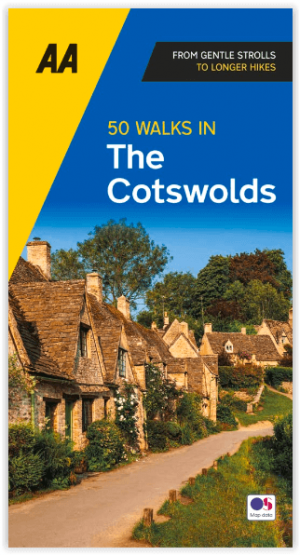
Wandelgids Cotswolds AONB 50 walks guide - AA Publishing • 9780749583224
Cotswolds AONB - 50 walks guide - AA Publishing Productomschrijving: Wandelen is een van de favoriete vrijetijdsbestedingen van Groot-Brittannië. AA 50 Walks in the Cotswolds bevat een verscheidenheid aan uitgestippelde wandelingen van 3 tot 12 km, geschikt voor alle niveaus. Het boek bevat alle praktische details die u nodig hebt, vergezeld van boeiende achtergrondinformatie over de gesch…

Wandelgids Walking in the Forest of Dean - Cicerone • 9781852846893
Wandelgids - Walking in the Forest of Dean - Cicerone Productomschrijving: Een gids over 25 wandelingen in de Forest of Dean, met alle informatie die nodig is om te genieten van een scala aan wandelingen in de dallen en de open ruimtes van dit oude gebied. Van korte 4-mijl lange wandelingen tot volle dagsecties van interlokale paden zoals de Offa's Dyke Path en Gloucestershire Way, is deze…

Wandelgids Walking the Thames Path National Trail - Cicerone • 9781786311481
Thames Path National Trail - Cicerone Productomschrijving: Een gloednieuwe wandelgids vover het Theemspad, een National Trail van 180 mijl tussen de Thames Barrier in Londen en de bron van de rivier in Gloucestershire, door Windsor, Oxford en het platteland. Biedt volledige informatie over deze gemakkelijke route langs de rivier die ongeveer twee weken in beslag neemt. Inclusief een 1:25K …