
Wandelgids - Hampshire's Test Way walking guide - Cicerone
Inkpen Beacon to the Eling Tide Mill near Southampton Water
Korte omschrijving
Hampshire's Test Way walking guide - Cicerone Productomschrijving: Gloednieuwe wandelgids van de 71 km (44 mijl) Test Way in Hampshire van hoog op de krijtrotsen van Inkpen Beacon naar de El...

Specificaties
- Uitgever: CICERONE Press
- ISBN-13: 9781852849535
- HOOFDCATEGORIEËN: Wandelgids
- Activiteiten: Wandelen, Hiking & Trekking
- Auteur: Malcolm Leatherdale
- Regio: Hampshire, England, South East England
- Land: England, United Kingdom, Great Britain
- Lange afstand wandelroutes: Hampshire's Test Way, England (71 km)
- AONB - Area of Outstanding Beauty: North Wessex Downs AONB
- Blz.: 160
- Schaal: 1:25000
- Afmeting: 12x17
- Editie: 1
- Taal: Engels
Volledige omschrijving
Hampshire's Test Way walking guide - Cicerone
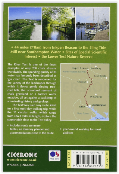
Productomschrijving: Gloednieuwe wandelgids van de 71 km (44 mijl) Test Way in Hampshire van hoog op de krijtrotsen van Inkpen Beacon naar de Eling Tide Mill bij Southampton Water. U volgt de prachtige, kristalheldere rivier de Test en komt langs pittoreske dorpjes en fascinerende historische plaatsen. Bevat ook 15 dagwandelingen om dit prachtige deel van pastoraal Engeland te verkennen.
Engelse omschrijving: Guidebook to walking the 71km (44 mile) Test Way in Hampshire from high on the chalk downs of Inkpen Beacon to the Eling Tide Mill near Southampton Water. Following the beautiful, crystal clear River Test, it passes picturesque villages and fascinating historic sites. Also includes 15 day walks to explore this lovely part of pastoral England.
Seasons:
All year
Centres:
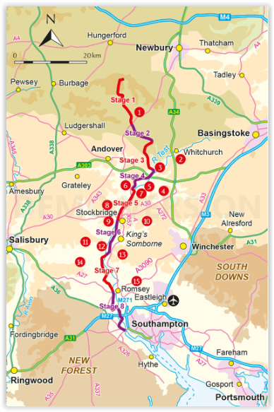
Beginning at Inkpen Beacon, the Test Way passes close to or through St Mary Bourne, Whitchurch, Stockbridge, King's Somborne, Broughton, Mottisfont, Romsey and ends at Eling Totton.
Difficulty:
All abilities are catered for. Several of the walks and the first half of the Test Way are perhaps more of a challenge. The second half is fairly flat as are the majority of the walks. No special equipment required.
Must See:
Inkpen Beacon; Whitchurch Silk Mill; Chilbolton Common; Longstock Park Water Garden; Danebury Iron Age hill fort; Stockbridge Down; Mottisfont Abbey; Romsey Abbey, Romsey Signal Box - restored - formerly part of the dismantled 'Sprat and Winkle' railway; Broadlands House Romsey; Lower Test Nature Reserve; Eling Tide Mill Totton.
Overzichtskaarten

Area's of Outstanding Natural Beauty - AONB's UK
Area's of Outstanding Natural Beauty - AONB's UK

Producten op de overzichtskaart
Klik op een product om naar de detailpagina te gaan.
- Wandelgids - Guide to the Cotswolds AONB - AA
- Wandelkaart 24 - Chilterns AONB - AA
- Fietskaart- en Mtb kaart - The Cotswolds - Goldeneye
- Wandelgids - Cotswold classic walks guidebook - Goldeneye
- Wandelkaart - Cotswold South AONB - Goldeneye
- Wandelgids - Exploring the Cotswolds - Goldeneye
- Wandelgids - Cotswold Classic Walks - Goldeneye
- Wandelkaart - Cotswolds- Malverns & Forest of Dean - Goldeneye
- Wandelgids - The Cotswold Way 30 classic routes - Cicerone
- Wandelgids - Kent walking guide - Cicerone
- Wandelgids - North Downs Way Nat. trail - Cicerone
- Wandelgids - Chilterns walking guide - Cicerone
- Wandelgids - Suffolk coast & Heaths walks - Cicerone
- Wandelgids - North Downs Way - Map Booklet - Cicerone
- Wandelgids - North Pennines AONB walking guide - Cicerone
- Wandelgids - Ridgeway National Trail - Cicerone
- Wandelgids - Forest of Bowland & Pendle - Cicerone
- Wandelgids - Hampshire's Test Way walking guide - Cicerone
- Wandelgids & Fietsgids - The Cotswold AONB - Cicerone
- Wandelgids - Walking on the Gower - Cicerone
- Wandelgids - North Wessex Downs - Cicerone Press
- Wandelgids - Walking on the North Wessex Downs - Cicerone
- Wandelgids - Silverdale & Arnside AONB - Cicerone
- Wandelgids - The Kennet and Avon Canal walking guide - Cicerone
- Wandelgids - North Downs Way- 246 km - Trailblazer
- Wandelkaart OL2 - Yorkshire Dales- Southern & Western Areas - OSI
- Wandelkaart OL19 - Howgill Fells and Upper Eden Valley - OSI
- Wandelkaart OL21 - South Pennines - Yorkshire - OSI
- Wandelkaart OL31 - North Pennines- Teesdale & Weardale - OSI
- Wandelkaart OL40 - The Broads - OSI
- Wandelkaart OL41 - Forest of Bowland & Ribblesdale - OSI
- Wandelkaart OL45 - The Cotswolds AONB- Gloucestershire - OSI
- Wandelkaart 108 - Lower Tamer Valley & Plymouth- Cornwall- OSI
- Wandelkaart 115 - Exmouth & Sidmouth- Devon - OSI
- Wandelkaart 137 - Ashford- Kent downs AONB- England - OSI
- Wandelkaart 140 - Quantock Hills AONB- Somerset - OSI
- Wandelkaart 140 - Quantock Hills AONB & Bridgwater- Devon - OSI
- Wandelkaart 147 - Sevenoaks & Tonbridge- Kent - OSI
- Wandelkaart 164 - Gower AONB & Gwyr- South Wales - OSI
- Wandelkaart 164 - Gower AONB & Gwyr- Wales - OSI
- Wandelkaart 171 - Chiltern Hills West & Henley-on-Thames OSI
- Wandelkaart 171 - Chiltern Hills West AONB- Wycombe - OSI
- Wandelkaart 172 - Chiltern Hills East AONB- Wycombe - OSI
- Wandelkaart 181 - Chiltern Hills AONB North- England - OSI
- Wandelkaart 181 - Chiltern Hills North AONB- Wycombe - OSI
- Wandelkaart 190 - Malvern Hills & Bredon Hill - OSI
- Wandelkaart 190 - Malvern Hills AONB & Bredon Hill - OSI
- Wandelkaart 203 - Ludlow- Shropshire Hills AONB - OSI
- Wandelkaart 217 - Long Mynd & Wenlock Edge- Schropshire- OSI
- Wandelkaart 254 - Lleyn Peninsular East- North Wales - OSI
- Wandelkaart 261 - Boston- Lincolnshire AONB - OSI
- Wandelkaart 262 - Anglesey West- Wales AONB - OSI
- Wandelkaart 263 - Anglesey East AONB- Wales - OSI
- Wandelkaart 273 - Lincolnshire Wolds South AONB - OSI
- Wandelkaart 282 - Lincolnshire Wolds North AONB - OSI
- Wandelkaart 298 - Nidderdale AONB- Yorkshire - OSI
- Wandelkaart 298 - Nidderdale AONB North Yorkshire - OSI
- Wandelkaart 300 - Howardian Hills AONB - OSI
- Wandelkaart 300 - Howardian Hills AONB & Malton - OSI
- Wandelkaart - Mourne Mountains N. Ireland - Harvey maps
- Wandelkaart - Fietskaart Forest of Bowland - Harvey maps
- Wandelkaart XT40 - Anglesey Coastal Path N. Wales - Harvey Maps
- Wandelkaart XT40 - Pennine Way Noord - Harvey Maps
- Wandelkaart XT40 - Pennine Way Zuid - Harvey Maps
- Wandelgids Cotswold - Way Two-way trekking guide - Knife Edge
- Reisgids Oxford & the Cotswolds AONB - Edicola
- Reisgids Cotswolds England - Rough Guides
- Reisgids Go Slow- Sussex & the South Downs- Weald & Coast - Bradt
- Travelguide Oxford & The Cotswolds pocket guide - Lonely Planet
- Wandelgids - The Ridgeway National trail - Trailblazer
Artikelen uit dezelfde regio

Wandelkaart 131 Romsey & Andover Hampshire - OSI • 9780319243275
Wandelkaart Romsey- Andover & Test Valley - Hampshire England Omvat ook: Stockbridge & Ludgershall. Productbeschrijving: Kaart nummer 131 in de OS Explorer reeks heeft betrekking op het gebied van Oxenwood en Ashmansworth in het noorden tot Romsey en Redlynch in het zuiden. Hoogtepunten van het gebied zijn onder andere: Andover, Ludgershall, Stockbridge en de wandelingen van de Test Wa…

Wandelkaart 170 Abingdon- Wantage & Vale - OSI • 9780319470428
Wandelkaart Abingdon- Wantage & Vale - Oxfordshire England Omvat ook: Wallingford & Faringdon. Productbeschrijving: Kaart nummer 170 in de OS Explorer kaarten reeks heeft betrekking op The Vale of the White Horse, en het paard zelf in Uffington, North Wessex Downs AONB, een verzameling van grote Westenlijke bossen en een klein deel van de Chiltern Hills AONB. Ook zijn de nederzettingen…

Wandelgids The South Downs Way - Rucksack readers • 9781898481447
Wandelgids South Downs Way - Omvat: Hampshire Sussex South East England Productomschrijving: De South Downs Way loopt voor 100 mijl (160 km) van de kathedraalstad van Winchester naar de spectaculaire witte kliffen van East Sussex, ter hoogte van Eastbourne. De golvende route biedt noorden wijds uitzicht over de zee. Het vormt de ruggengraat van Britains nieuwste Nationaal Park, met gl…

Mountainbikegids South Downs - 26 off road routes - Cicerone • 9781852846459
Mountainbikegids South Downs - 26 off road routes - Cicerone Productomschrijving: Een gids voor berg (MTB) fietsroutes op de South Downs van Hampshire en Sussex, tussen Winchester, Brighton en Eastbourne. De 26 routes beschreven in dit boek nemen deel aan achtbanen, toegewijde bos singletrack en grote afdalingen. Ritten worden gequoteerd voor alle vaardigheden met informatie over plaatseli…

Wandelkaart 159 Reading- Wokingham & Pangbourne - OSI • 9780319470312
Wandelkaart Reading - Wokingham & Pangbourne Omvat ook: Wokingham & Pangbourne. Productbeschrijving: Kaart nummer 159 in de OS Explorer kaarten reeks beslaat een gebied rond Reading, met inbegrip van delen van de North Wessex Downs AONB en Chilterns AONB gebieden of Outstanding Natural Beauty AONB. De Thames pad National Trail loopt over het bovenste gedeelte van de kaart voorbij Pangb…