
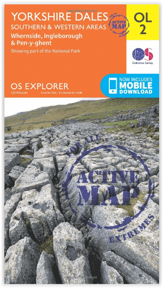
Wandelkaart OL2 Yorkshire Dales- Southern & Western Areas - OSI
Stainforth - Arncliffe - Conistone - Settle - Malham - Bordley
Korte omschrijving
Wandelkaart Yorkshire Dales- Southern & Western Areas - OSI Productomschrijving: Kaart nummer OL2 in de OS Explorer kaartenserie is de ideale kaart om te gebruiken bij het verkennen van de z...

Specificaties
- Uitgever: Ordnance Survey
- ISBN-13: 9780319475331
- HOOFDCATEGORIEËN: Wandelkaart
- Activiteiten: Wandelen, Hiking & Trekking
- Regio: Yorkshire, England
- Land: England
- Waterafstotende kaart: Ordnance Survey ACTIVE Explorer Weatherproof Maps
- Nationale parken: Yorkshire Dales NP, England
- AONB - Area of Outstanding Beauty: Forest of Bowland AONB, Nidderdale AONB
- Schaal: 1:25000
- Afmeting: 13x24
- Taal: Engels
- Reeks: Explorer ACTIVE
Volledige omschrijving
Wandelkaart Yorkshire Dales- Southern & Western Areas - OSI
Productomschrijving: Kaart nummer OL2 in de OS Explorer kaartenserie is de ideale kaart om te gebruiken bij het verkennen van de zuidelijke en westelijke gebieden van de Yorkshire Dales, waaronder Whernside, Ingleborough en Pen-y-ghent. Hoogtepunten: De drie pieken van Yorkshire, The Devils Bridge bij Kirkby Lonsdale, Leeds to Liverpool Canal bij Skipton, The Pennine Way, Settle, en Old Town.
Inclusief mobiele downloadBij deze kaart ontvangt u een code voor gebruik op uw iOS of Android smartphone of tablet. Meer informatie vindt u bij FAQ over mobiel downloaden.
Omvat:
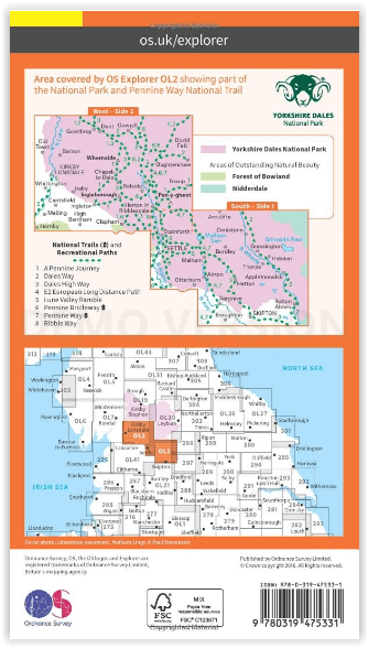
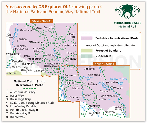
South - Side 1: Stainforth, Arncliffe, Conistone, Settle, Malham, Bordley, Grassington, Hebden, Thorpe, Otterburn, Airton, Appletreewick, Hetton, Gargrave, Broughton, Skipton & Bolton Abbey.
West - Side 2: Dent, Cowgill, Gawthrop, Bardon, Whernside, Dodd Fell, Kirby Longdale, Whittington, Ireby, Chapelle-Dale, Selside, Oughtershaw, Foxup, Pen-y-yghent, Cantsfield, Ingleton, Melling, Hornby, High Bentham, Clapham & Horton in riddersdale.
National Trails and recreational paths:
- A Pennine Journey - Dales Way - Dales High Way - E2 European Long distance Path - Lune Valley Ramble - Pennine ridleway - Pennine Way - Ribble WayEngelse omschrijving: Map sheet number OL2 in the OS Explorer map series is the ideal map to use when exploring the South and West areas of the Yorkshire Dales including Whernside, Ingleborough and Pen-y-ghent. Highlights: The Yorkshire three peaks, The Devils Bridge at Kirkby Lonsdale, Leeds to Liverpool Canal at Skipton, The Pennine Way, Settle, and Old Town.
Includes mobile downloadWith this map you will receive a code for use on your iOS or Android smartphone or tablet. Find our more at Mobile Download FAQ.
Locatie op kaart
Overzichtskaarten

Area's of Outstanding Natural Beauty - AONB's UK
Area's of Outstanding Natural Beauty - AONB's UK

Producten op de overzichtskaart
Klik op een product om naar de detailpagina te gaan.
- Wandelgids - Guide to the Cotswolds AONB - AA
- Wandelkaart 24 - Chilterns AONB - AA
- Fietskaart- en Mtb kaart - The Cotswolds - Goldeneye
- Wandelgids - Cotswold classic walks guidebook - Goldeneye
- Wandelkaart - Cotswold South AONB - Goldeneye
- Wandelgids - Exploring the Cotswolds - Goldeneye
- Wandelgids - Cotswold Classic Walks - Goldeneye
- Wandelkaart - Cotswolds- Malverns & Forest of Dean - Goldeneye
- Wandelgids - The Cotswold Way 30 classic routes - Cicerone
- Wandelgids - Kent walking guide - Cicerone
- Wandelgids - North Downs Way Nat. trail - Cicerone
- Wandelgids - Chilterns walking guide - Cicerone
- Wandelgids - Suffolk coast & Heaths walks - Cicerone
- Wandelgids - North Downs Way - Map Booklet - Cicerone
- Wandelgids - North Pennines AONB walking guide - Cicerone
- Wandelgids - Ridgeway National Trail - Cicerone
- Wandelgids - Forest of Bowland & Pendle - Cicerone
- Wandelgids - Hampshire's Test Way walking guide - Cicerone
- Wandelgids & Fietsgids - The Cotswold AONB - Cicerone
- Wandelgids - Walking on the Gower - Cicerone
- Wandelgids - North Wessex Downs - Cicerone Press
- Wandelgids - Walking on the North Wessex Downs - Cicerone
- Wandelgids - Silverdale & Arnside AONB - Cicerone
- Wandelgids - The Kennet and Avon Canal walking guide - Cicerone
- Wandelgids - North Downs Way- 246 km - Trailblazer
- Wandelkaart OL2 - Yorkshire Dales- Southern & Western Areas - OSI
- Wandelkaart OL19 - Howgill Fells and Upper Eden Valley - OSI
- Wandelkaart OL21 - South Pennines - Yorkshire - OSI
- Wandelkaart OL31 - North Pennines- Teesdale & Weardale - OSI
- Wandelkaart OL40 - The Broads - OSI
- Wandelkaart OL41 - Forest of Bowland & Ribblesdale - OSI
- Wandelkaart OL45 - The Cotswolds AONB- Gloucestershire - OSI
- Wandelkaart 108 - Lower Tamer Valley & Plymouth- Cornwall- OSI
- Wandelkaart 115 - Exmouth & Sidmouth- Devon - OSI
- Wandelkaart 137 - Ashford- Kent downs AONB- England - OSI
- Wandelkaart 140 - Quantock Hills AONB- Somerset - OSI
- Wandelkaart 140 - Quantock Hills AONB & Bridgwater- Devon - OSI
- Wandelkaart 147 - Sevenoaks & Tonbridge- Kent - OSI
- Wandelkaart 164 - Gower AONB & Gwyr- South Wales - OSI
- Wandelkaart 164 - Gower AONB & Gwyr- Wales - OSI
- Wandelkaart 171 - Chiltern Hills West & Henley-on-Thames OSI
- Wandelkaart 171 - Chiltern Hills West AONB- Wycombe - OSI
- Wandelkaart 172 - Chiltern Hills East AONB- Wycombe - OSI
- Wandelkaart 181 - Chiltern Hills AONB North- England - OSI
- Wandelkaart 181 - Chiltern Hills North AONB- Wycombe - OSI
- Wandelkaart 190 - Malvern Hills & Bredon Hill - OSI
- Wandelkaart 190 - Malvern Hills AONB & Bredon Hill - OSI
- Wandelkaart 203 - Ludlow- Shropshire Hills AONB - OSI
- Wandelkaart 217 - Long Mynd & Wenlock Edge- Schropshire- OSI
- Wandelkaart 254 - Lleyn Peninsular East- North Wales - OSI
- Wandelkaart 261 - Boston- Lincolnshire AONB - OSI
- Wandelkaart 262 - Anglesey West- Wales AONB - OSI
- Wandelkaart 263 - Anglesey East AONB- Wales - OSI
- Wandelkaart 273 - Lincolnshire Wolds South AONB - OSI
- Wandelkaart 282 - Lincolnshire Wolds North AONB - OSI
- Wandelkaart 298 - Nidderdale AONB- Yorkshire - OSI
- Wandelkaart 298 - Nidderdale AONB North Yorkshire - OSI
- Wandelkaart 300 - Howardian Hills AONB - OSI
- Wandelkaart 300 - Howardian Hills AONB & Malton - OSI
- Wandelkaart - Mourne Mountains N. Ireland - Harvey maps
- Wandelkaart - Fietskaart Forest of Bowland - Harvey maps
- Wandelkaart XT40 - Anglesey Coastal Path N. Wales - Harvey Maps
- Wandelkaart XT40 - Pennine Way Noord - Harvey Maps
- Wandelkaart XT40 - Pennine Way Zuid - Harvey Maps
- Wandelgids Cotswold - Way Two-way trekking guide - Knife Edge
- Reisgids Oxford & the Cotswolds AONB - Edicola
- Reisgids Cotswolds England - Rough Guides
- Reisgids Go Slow- Sussex & the South Downs- Weald & Coast - Bradt
- Travelguide Oxford & The Cotswolds pocket guide - Lonely Planet
- Wandelgids - The Ridgeway National trail - Trailblazer

OSI Explorer & Explorer Active - Noord Engeland - Lake District
OSI Explorer & Explorer Active - Noord Engeland - Lake District

Producten op de overzichtskaart
Klik op een product om naar de detailpagina te gaan.
- Wandelkaart 275 Liverpool- South West England - OSI
- Wandelkaart 276 Bolton- Wigan & Warrington- Machester - OSI
- Wandelkaart 277 Manchester & Salford - OSI
- Wandelkaart 278 Sheffield & Barnsley- South Yorkshire - OSI
- Wandelkaart 279 Doncaster- South Yorkshire - OSI
- Wandelkaart 280 Isle of Axholme- Lincolnshire - OSI
- Wandelkaart 281 Ancholme Valley- Lincolnshire - OSI
- Wandelkaart 283 Louth & Mablethorpe- Lincolnshire - OSI
- Wandelkaart 284 Grimsby- Cleethorpes & Immingham - OSI
- Wandelkaart 285 Southport & Chorley- Merseyside - OSI
- Wandelkaart 286 Blackpool & Preston- Lancashire - OSI
- Wandelkaart 287 West Pennine Moors- Lankashire - OSI
- Wandelkaart 288 Bradford & Huddersfield- West Yorkshire - OSI
- Wandelkaart 289 Leeds- Harrogate- Wetherby & Pontefract - OSI
- Wandelkaart 290 York- Selby & Tadcaster- North Yorkshire - OSI
- Wandelkaart 291 Goole & Gilberdyke- Yorkshire - OSI
- Wandelkaart 292 Withernsea & Spurn Head- East Riding - OSI
- Wandelkaart 293 Kingston upon Hull & Beverley - OSI
- Wandelkaart 294 Market Weighton & central Yorkshire Wolds - OSI
- Wandelkaart 295 Bridlington- Driffield & Hornsea - OSI
- Wandelkaart 296 Lancaster- Morecambe & Fleetwood - OSI
- Wandelkaart 297 Lower Wharfedale & Washburn Valley - OSI
- Wandelkaart 298 Nidderdale AONB- Yorkshire - OSI
- Wandelkaart 299 Ripon & Boroughbridge- North Yorkshire - OSI
- Wandelkaart 300 Howardian Hills AONB & Malton - OSI
- Wandelkaart 301 Scarborough- Bridlington & Flamborough
- Wandelkaart 302 Northallerton & Thirsk- North Yorkshire
- Wandelkaart 303 Whitehaven & Workington - OSI
- Wandelkaart 304 Darlington & Richmond- North Cleveland
- Wandelkaart 305 Bishop Auckland & Durham - OSI
- Wandelkaart 306 Middlesbrough & Hartlepool - OSI
- Wandelkaart 307 Consett & Derwent reservoir - OSI
- Wandelkaart 308 Durham & Sunderland- England - OSI
- Wandelkaart 314 Solway Firth- Wigton & Silloth - OSI
- Wandelkaart 315 Carlisle- Brampton- Longtown - OSI
- Wandelkaart 316 Newcastle upon Tyne- Northumberland- OSI
- Wandelkaart OL2 Yorkshire Dales- Southern & Western Areas - OSI
- Wandelkaart OL19 Howgill Fells and Upper Eden Valley - OSI
- Wandelkaart OL21 South Pennines - Yorkshire - OSI
- Wandelkaart OL26 North York Moors - Western area - OSI
- Wandelkaart OL27 North York Moors- Eastern area - OSI
- Wandelkaart OL30 Yorkshire Dales - Yorkshire England - OSI
- Wandelkaart OL31 North Pennines- Teesdale & Weardale - OSI
- Wandelkaart OL41 Forest of Bowland & Ribblesdale - OSI
- Wandelkaart OL43 Hadrian's Wall - OSI
Artikelen uit dezelfde regio

Fietsgids Cycling The Yorkshire Dales - Cicerone • 9781786310170
Fietsgids - Cycling The Yorkshire Dales - Cicerone Productomschrijving: Deze gids beschrijft 23-dagroutes, gesorteerd op afstand, klimgradatie en algehele helling, allemaal geschikt voor racefietsen en geïllustreerd met gedetailleerde kaarten en profielen. Bovendien neemt een route van zes etappes alle hoogtepunten in beslag, waaronder Grassington, Leyburn, Hawes, Kirkby Stephen, Ingleton …

Wandelkaart 295 Bridlington Driffield & Hornsea - OSI • 9780319245477
Wandelkaart Bridlington- Driffield & Hornsea - Yorkshire Productbeschrijving: 295 / Bridlington, Driffield & Hornsea, East Riding of Yorkshire, England - Van Hornsea langs de kust naar Bridlington en de binnenvaart tot Driffield. OS Explorer kaart 295 is de perfecte partner voor al uw outdoor avonturen. Het omvat ook delen van vier recreatieve paden: landtong way, Hornsea Rail Trail,…

Wandelgids Northern England Coast to Coast walk - Cicerone • 9781852847593
Wandelgids - Northern England Coast to Coast walk - Cicerone Productomschrijving: Een wandelgids, uitgebreid in zijn genre, die u van kust naar kust brengt in de noordelijke regio's van Engeland. Deze streek is gekenmerkt door zijn geschiedenis met resten van zelf nog de Romeinse tijd. De regio is ook bekend om zijn Hadrian's Wall path. Product description: First devised by Alfred Wain…

Wandelgids The Dales Way - Trailblazer • 9781912716302
Wandelgids The Dales Way - Trailblazer Publications Productomschrijving: Dales Way: Ilkley to Bowness-on-Windermere - Het langeafstandswandelpad Dales Way begint in Ilkley, in het Yorkshire Dales National Park en loopt over 81 mijl (130 km) om te eindigen in het Lake District, in Bowness-on-Windermere. Het volgt de prachtige rivier de Wharf richting Ribblehead, meandert dan langs de rivier…

Wandelkaart OL31 North Pennines- Teesdale & Weardale - OSI • 9780319469491
Wandelkaart North Pennines- Teesdale & Weardale - England Omvat ook: Teesdale & Weardale Productbeschrijving: Kaart nummer OL31 in de OS Explorer kaarten reeks, omvat de North Pennines AONB, Barnard Castle, Alton en Allenheads. Hoogtepunten van het gebied zijn onder andere: Hamsterley community Forest, Middleton, Milburn Forest, Cow green en Burnhope Reservoirs, Weardale en een deel va…