

Wandelgids - Cotswold Classic Walks - Goldeneye
Met 25 rondwandelingen - AONB regio

Korte omschrijving
Wandelgidsen Somerset South West England, Warwickshire, West Midlands, Wiltshire, West England, Oxfordshire west England en Worcestershire, West England van Goldeneye. Ideaal voor tochten in England.
Cotswold Classic Walks - Goldeneye Productomschrijving: Met 25 rondwandelingen helpt dit boek u een uitvalsbasis te vinden om de auto te ontvluchten en te genieten van een weekend vol frisse...

Specificaties
- Uitgever: Goldeneye
- ISBN-13: 9781859652916
- HOOFDCATEGORIEËN: Fietsgids
- Activiteiten: Wandelen, Hiking & Trekking
- Auteur: William Fricker
- Regio: Oxfordshire west England, Somerset South West England, Warwickshire, West Midlands, Wiltshire, West England, Worcestershire, West England
- Land: England
- AONB - Area of Outstanding Beauty: Cotswolds AONB
- Editie: 4
- Taal: Engels
Volledige omschrijving
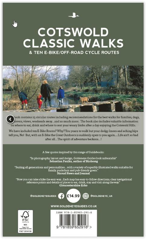
Cotswold Classic Walks - Goldeneye
Productomschrijving: Met 25 rondwandelingen helpt dit boek u een uitvalsbasis te vinden om de auto te ontvluchten en te genieten van een weekend vol frisse lucht en beweging....
Sommige wandelingen bieden verschillende routemogelijkheden en links naar andere wandelingen. Hoe beslist u welke wandeling u gaat doen? - Waar zijn de mooiste uitzichten? - Waar vind je eenzaamheid? - Dit boek helpt u een wandeling te vinden die bij u past, of het nu gaat om een wandeling met de kinderwagen, met het gezin, met de hond, door het bos, met bluebell of een kroegentocht. De kaarten zijn duidelijk, en zelfs als u kaarten moeilijk te lezen vindt, zullen de instructies u door de wandeling loodsen.
Engelse omschrijving: With 25 circular walks, this book will help you find a base to escape from your car and enjoy a weekend of fresh air and exercise....
Some walks offer various route options and links to other walks. How do you decide which walk to undertake? Where are the best views? Where to find solitude? This book will guide you to find a walk that suits you, whether it be a pushchair, family, dog, woodland, bluebell or a pub crawl. The maps are clear, and even if you find maps difficult to read, the instructions will get you round the walk.
Locatie op kaart
Overzichtskaarten

Area's of Outstanding Natural Beauty - AONB's UK
Area's of Outstanding Natural Beauty - AONB's UK

Producten op de overzichtskaart
Klik op een product om naar de detailpagina te gaan.
- Wandelgids - Guide to the Cotswolds AONB - AA
- Wandelkaart 24 - Chilterns AONB - AA
- Wandelgids - Cotswold classic walks guidebook - Goldeneye
- Wandelgids - Cotswold Classic Walks - Goldeneye
- Wandelgids - The Cotswold Way 30 classic routes - Cicerone
- Wandelgids - North Downs Way Nat. trail - Cicerone
- Wandelgids - Chilterns walking guide - Cicerone
- Wandelgids - Suffolk coast & Heaths walks - Cicerone
- Wandelgids - North Downs Way - Map Booklet - Cicerone
- Wandelgids - North Pennines AONB walking guide - Cicerone
- Wandelgids - Ridgeway National Trail - Cicerone
- Wandelgids - Forest of Bowland & Pendle - Cicerone
- Wandelgids - Hampshire's Test Way walking guide - Cicerone
- Wandelgids & Fietsgids - The Cotswold AONB - Cicerone
- Wandelgids - North Wessex Downs - Cicerone Press
- Wandelgids - Walking on the North Wessex Downs - Cicerone
- Wandelgids - Silverdale & Arnside AONB - Cicerone
- Wandelkaart OL2 - Yorkshire Dales- Southern & Western Areas - OSI
- Wandelkaart OL19 - Howgill Fells and Upper Eden Valley - OSI
- Wandelkaart OL21 - South Pennines - Yorkshire - OSI
- Wandelkaart OL31 - North Pennines- Teesdale & Weardale - OSI
- Wandelkaart OL40 - The Broads - OSI
- Wandelkaart OL41 - Forest of Bowland & Ribblesdale - OSI
- Wandelkaart OL45 - The Cotswolds AONB- Gloucestershire - OSI
- Wandelkaart 108 - Lower Tamer Valley & Plymouth- Cornwall- OSI
- Wandelkaart 115 - Exmouth & Sidmouth- Devon - OSI
- Wandelkaart 137 - Ashford- Kent downs AONB- England - OSI
- Wandelkaart 140 - Quantock Hills AONB- Somerset - OSI
- Wandelkaart 140 - Quantock Hills AONB & Bridgwater- Devon - OSI
- Wandelkaart 147 - Sevenoaks & Tonbridge- Kent - OSI
- Wandelkaart 164 - Gower AONB & Gwyr- South Wales - OSI
- Wandelkaart 164 - Gower AONB & Gwyr- Wales - OSI
- Wandelkaart 171 - Chiltern Hills West & Henley-on-Thames OSI
- Wandelkaart 171 - Chiltern Hills West AONB- Wycombe - OSI
- Wandelkaart 172 - Chiltern Hills East AONB- Wycombe - OSI
- Wandelkaart 181 - Chiltern Hills AONB North- England - OSI
- Wandelkaart 181 - Chiltern Hills North AONB- Wycombe - OSI
- Wandelkaart 190 - Malvern Hills & Bredon Hill - OSI
- Wandelkaart 190 - Malvern Hills AONB & Bredon Hill - OSI
- Wandelkaart 203 - Ludlow- Shropshire Hills AONB - OSI
- Wandelkaart 217 - Long Mynd & Wenlock Edge- Schropshire- OSI
- Wandelkaart 254 - Lleyn Peninsular East- North Wales - OSI
- Wandelkaart 261 - Boston- Lincolnshire AONB - OSI
- Wandelkaart 262 - Anglesey West- Wales AONB - OSI
- Wandelkaart 263 - Anglesey East AONB- Wales - OSI
- Wandelkaart 273 - Lincolnshire Wolds South AONB - OSI
- Wandelkaart 282 - Lincolnshire Wolds North AONB - OSI
- Wandelkaart 298 - Nidderdale AONB- Yorkshire - OSI
- Wandelkaart 298 - Nidderdale AONB North Yorkshire - OSI
- Wandelkaart 300 - Howardian Hills AONB - OSI
- Wandelkaart 300 - Howardian Hills AONB & Malton - OSI
- Wandelkaart - Mourne Mountains N. Ireland - Harvey maps
- Wandelkaart - Fietskaart Forest of Bowland - Harvey maps
- Wandelkaart XT40 - Anglesey Coastal Path N. Wales - Harvey Maps
- Wandelkaart XT40 - Pennine Way Noord - Harvey Maps
- Wandelkaart XT40 - Pennine Way Zuid - Harvey Maps
- Wandelgids Cotswold - Way Two-way trekking guide - Knife Edge
- Reisgids Cotswolds England - Rough Guides
Artikelen uit dezelfde regio

Wandelgids Cotswolds - Heart of the Cotswolds - Rucksack Readers • 9781913817268
Wandelgids Cotswolds - Heart of the Cotswolds - Rucksack Productomschrijving: The Cotswolds AONB is quintessentially English, with its rich cultural history, medieval ‘wool’ churches and charming domestic architecture of stone, slate and thatch. The book offers three options for walking in the heart of this wonderful area: a 94-mile (151-km) grand tour starting from Cheltenham, and two sh…

Reisgids Cotswolds Top 10 - William Fricker - Goldeneye • 9781859653081
Reisgids Cotswolds - Goldeneye Productomschrijving: Ervaren Cotswold-reisschrijver William Fricker en zijn team van Goldeneye geven hun mening over de mooiste dorpen om te bezoeken. Een breed scala aan activiteiten om aan deel te nemen, van het bezoeken van landhuizen en tuinen, de prachtige kerken en de dromerige rivierdalen. Een breed scala aan overnachtingsmogelijkheden, van landelijke …

Wandelkaart 170 Abingdon & Wantage - Oxfordshire - OSI • 9780319243633
Wandelkaart Abingdon & Wantage - Oxfordshire England Productbeschrijving: 170 - Kaart van Abingdon, Wantage & Vale of White Horse - Kaart nummer 170 in de OS Explorer reeks heeft betrekking op het Vale of White Horse en Uffington, North Wessex Downs AONB, het Gemeenschappelijke grote Westelijk bos en een klein deel van de Chiltern Hills AONB. Ook zijn de nederzettingen van Lechlade on…
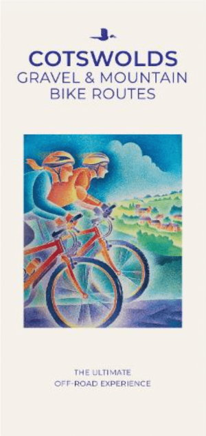
Moutainbike Cotswold Gravel & Mountain AONB - Goldeneye • 9781859653135
Moutainbike map Cotswold - Goldeneye Productomschrijving: Cotswold Gravel & Mountain Bike Routes: The Ultimate Off-Road Experience - Gravel & Mountain Bike Routes 18 (Paperback) When mountainbiking in the Cotswolds, in an Area of Outstanding Natural Beauty of AONB area, a lot of sportsfanatics & MTB fanatics are very interested, and cannot go wrong with this new Goldeneye mountainbiki…
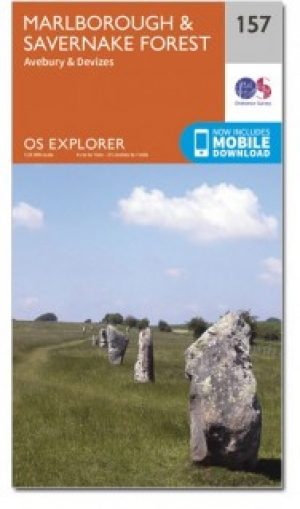
Wandelkaart 157 Marlborough & Savernake Forest - OSI • 9780319470299
Wandelkaart Marlborough & Savernake Forest - Wiltshire Omvat ook: Avebury & Devizes. Productbeschrijving: Kaart nummer 157 in de OS Explorer kaarten reeks omvat Marlborough, Avebury en Devizes in Wiltshire. Hoogtepunten van het gebied zijn onder andere: een deel van de Great Western Community Forest, North Wessex Downs AONB, Savernake Forest, Avebury Rings, Wessex Ridgeway, The Ridgewa…