
Wandelkaart OL40 The Broads - OSI
The Broads National Park
Korte omschrijving
Wandelkaart The Broads National Park - OSI Productomschrijving: Kaart OL40 in de OS Explorer serie bestrijkt The Broads, een lid van de familie van nationale parken. De rivieren zijn de Bure...

Specificaties
- Uitgever: Ordnance Survey
- ISBN-13: 9780319475485
- HOOFDCATEGORIEËN: Wandelkaart
- Activiteiten: Wandelen, Hiking & Trekking
- Regio: Norfolk East England, Suffolk East Anglia
- Land: England
- Waterafstotende kaart: Ordnance Survey ACTIVE Explorer Weatherproof Maps
- Nationale parken: Broads National Park, England
- AONB - Area of Outstanding Beauty: Norfolk Coast AONB
- Schaal: 1:25000
- Afmeting: 13x24
- Taal: Engels
- Reeks: Explorer ACTIVE
Volledige omschrijving
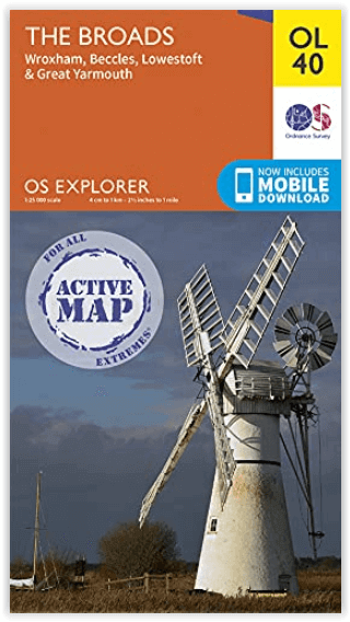
Wandelkaart The Broads National Park - OSI
Productomschrijving: Kaart OL40 in de OS Explorer serie bestrijkt The Broads, een lid van de familie van nationale parken. De rivieren zijn de Bure, Ant, Thurne, Yare, Chet en Waveney. De kaart toont ook de kusten van Norfolk en Suffolk en de badplaatsen Great Yarmouth en Lowestoft. Een ander hoogtepunt van het gebied is de stad Norwich.
Inclusief mobiele downloadBij deze kaart ontvangt u een code voor gebruik op uw iOS- of Android-smartphone of -tablet. Meer informatie vindt u bij Veelgestelde vragen over mobiel downloaden.
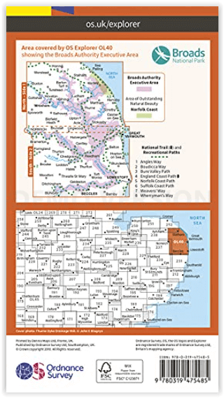
Nationale wandelroutes:
- Angles Way - Boucicca Way - Bure Valley Path - England Coast Path - Norfolk Coast PAth - Suffolk Coast Path - Weaver's Way - Wherryman's Way
Engelse omschrijving: Map sheet OL40 in the OS Explorer series covers the Broads, a member of the national park family. Its rivers are the Bure, Ant, Thurne, Yare, Chet and Waveney. The map also shows the Norfolk and Suffolk coasts and the seaside towns of Great Yarmouth and Lowestoft. Another highlight of the area is the city of Norwich.
Includes mobile downloadWith this map you will receive a code for use on your iOS or Android smartphone or tablet. Find our more at Mobile Download FAQ.
.png)
Locatie op kaart
Overzichtskaarten

Area's of Outstanding Natural Beauty - AONB's UK
Area's of Outstanding Natural Beauty - AONB's UK

Producten op de overzichtskaart
Klik op een product om naar de detailpagina te gaan.
- Wandelgids - Guide to the Cotswolds AONB - AA
- Wandelkaart 24 - Chilterns AONB - AA
- Fietskaart- en Mtb kaart - The Cotswolds - Goldeneye
- Wandelgids - Cotswold classic walks guidebook - Goldeneye
- Wandelkaart - Cotswold South AONB - Goldeneye
- Wandelgids - Exploring the Cotswolds - Goldeneye
- Wandelgids - Cotswold Classic Walks - Goldeneye
- Wandelkaart - Cotswolds- Malverns & Forest of Dean - Goldeneye
- Wandelgids - The Cotswold Way 30 classic routes - Cicerone
- Wandelgids - Kent walking guide - Cicerone
- Wandelgids - North Downs Way Nat. trail - Cicerone
- Wandelgids - Chilterns walking guide - Cicerone
- Wandelgids - Suffolk coast & Heaths walks - Cicerone
- Wandelgids - North Downs Way - Map Booklet - Cicerone
- Wandelgids - North Pennines AONB walking guide - Cicerone
- Wandelgids - Ridgeway National Trail - Cicerone
- Wandelgids - Forest of Bowland & Pendle - Cicerone
- Wandelgids - Hampshire's Test Way walking guide - Cicerone
- Wandelgids & Fietsgids - The Cotswold AONB - Cicerone
- Wandelgids - Walking on the Gower - Cicerone
- Wandelgids - North Wessex Downs - Cicerone Press
- Wandelgids - Walking on the North Wessex Downs - Cicerone
- Wandelgids - Silverdale & Arnside AONB - Cicerone
- Wandelgids - The Kennet and Avon Canal walking guide - Cicerone
- Wandelgids - North Downs Way- 246 km - Trailblazer
- Wandelkaart OL2 - Yorkshire Dales- Southern & Western Areas - OSI
- Wandelkaart OL19 - Howgill Fells and Upper Eden Valley - OSI
- Wandelkaart OL21 - South Pennines - Yorkshire - OSI
- Wandelkaart OL31 - North Pennines- Teesdale & Weardale - OSI
- Wandelkaart OL40 - The Broads - OSI
- Wandelkaart OL41 - Forest of Bowland & Ribblesdale - OSI
- Wandelkaart OL45 - The Cotswolds AONB- Gloucestershire - OSI
- Wandelkaart 108 - Lower Tamer Valley & Plymouth- Cornwall- OSI
- Wandelkaart 115 - Exmouth & Sidmouth- Devon - OSI
- Wandelkaart 137 - Ashford- Kent downs AONB- England - OSI
- Wandelkaart 140 - Quantock Hills AONB- Somerset - OSI
- Wandelkaart 140 - Quantock Hills AONB & Bridgwater- Devon - OSI
- Wandelkaart 147 - Sevenoaks & Tonbridge- Kent - OSI
- Wandelkaart 164 - Gower AONB & Gwyr- South Wales - OSI
- Wandelkaart 164 - Gower AONB & Gwyr- Wales - OSI
- Wandelkaart 171 - Chiltern Hills West & Henley-on-Thames OSI
- Wandelkaart 171 - Chiltern Hills West AONB- Wycombe - OSI
- Wandelkaart 172 - Chiltern Hills East AONB- Wycombe - OSI
- Wandelkaart 181 - Chiltern Hills AONB North- England - OSI
- Wandelkaart 181 - Chiltern Hills North AONB- Wycombe - OSI
- Wandelkaart 190 - Malvern Hills & Bredon Hill - OSI
- Wandelkaart 190 - Malvern Hills AONB & Bredon Hill - OSI
- Wandelkaart 203 - Ludlow- Shropshire Hills AONB - OSI
- Wandelkaart 217 - Long Mynd & Wenlock Edge- Schropshire- OSI
- Wandelkaart 254 - Lleyn Peninsular East- North Wales - OSI
- Wandelkaart 261 - Boston- Lincolnshire AONB - OSI
- Wandelkaart 262 - Anglesey West- Wales AONB - OSI
- Wandelkaart 263 - Anglesey East AONB- Wales - OSI
- Wandelkaart 273 - Lincolnshire Wolds South AONB - OSI
- Wandelkaart 282 - Lincolnshire Wolds North AONB - OSI
- Wandelkaart 298 - Nidderdale AONB- Yorkshire - OSI
- Wandelkaart 298 - Nidderdale AONB North Yorkshire - OSI
- Wandelkaart 300 - Howardian Hills AONB - OSI
- Wandelkaart 300 - Howardian Hills AONB & Malton - OSI
- Wandelkaart - Mourne Mountains N. Ireland - Harvey maps
- Wandelkaart - Fietskaart Forest of Bowland - Harvey maps
- Wandelkaart XT40 - Anglesey Coastal Path N. Wales - Harvey Maps
- Wandelkaart XT40 - Pennine Way Noord - Harvey Maps
- Wandelkaart XT40 - Pennine Way Zuid - Harvey Maps
- Wandelgids Cotswold - Way Two-way trekking guide - Knife Edge
- Reisgids Oxford & the Cotswolds AONB - Edicola
- Reisgids Cotswolds England - Rough Guides
- Reisgids Go Slow- Sussex & the South Downs- Weald & Coast - Bradt
- Travelguide Oxford & The Cotswolds pocket guide - Lonely Planet
- Wandelgids - The Ridgeway National trail - Trailblazer
Artikelen uit dezelfde regio

Wandelkaart 144 Thetford & Breckland Norfolk - OSI • 9780319474679
Wandelkaart Thetford- Breckland & Wymondham - Norfolk Productbeschrijving: Kaart nummer 144 uit de reeks van de OS Landranger is de ideale kaart voor planning van dagtrips en vakanties naar Norfolk. Deel van het Peddars Way & Norfolk coast path. De steden in het gebied van deze kaart die zijn opgenomen zijn Thetford, Diss, Wymondham, Breckland, Attleborough en Watton. De OS Landranger …

Wandelgids Suffolk coast & Heaths walks - Cicerone • 9781852848705
Wandelgids - Suffolk coast & Heaths walks - Cicerone Productomschrijving: 3 langeafstand wandelingen door deze prachtige AONB regio. Een omgeving van uitzonderlijk natuurlijk schoon, die bekend staat bij vele Engelsen als een uitstap- of weekend wandelplaats. De Cicerone gidsen zijn uniek in hun genre en bieden een prachtig overzicht over een van Engelands grootste aantrekkingspolen, de AO…

Wandelkaart 133 North East Norfolk - Cromer - Wroxham - OSI • 9780319475508
North East Norfolk- Cromer & Wroxham - OSI Productomschrijving: Kaart nummer 133 in de OS Landranger kaartenserie bestrijkt het noordoosten van Norfolk, Cromer, Holt, North Walsham, Aylsham, Sherringham en Wroxham en omvat Barton Broad en het zuidelijkste deel van de Peddars Way & Norfolk Coast Path. De kaart bestrijkt een gebied van 40 km bij 40 km (25 mijl bij 25 mijl). Engelse omsch…

Wandelkaart 250 Norfolk Coast West England - OSI • 9780319471227
Wandelkaart Norfolk Coast West - Norfolk England Omvat ook: King’s Lynn & Hunstanton. Productbeschrijving: Kaart nummer 250 in de OS Explorer kaarten reeks behandelt de noordkust west Norfolk en een paar van de binnelandse gebieden, met inbegrip van de steden van Hunstanton en King's Lynn, en kleinere nederzettingen zoals Holme-next-the-Sea, Burnham Deepdale en Woflington. Hoogtepunten…

Wandelkaart 132 King's Lynn & Fakenham England - OSI • 9780319474556
Wandelkaart North West Norfolk- King's Lynn & Fakenham Productbeschrijving: Kaart nummer 132 in de OS Landranger kaarten reeks heeft de oppervlakte van Noord west Norfolk, King's lynn, Wells-Next-The-Sea, Fakenham, Hunstanton, Dereham en Holmes volgende de zee. Andere hoogtepunten van het gebied: de Peddars Way & Norfolk Coast Path, Holkham Bay, Brancaster Bay en The Wash. De OS Landra…