
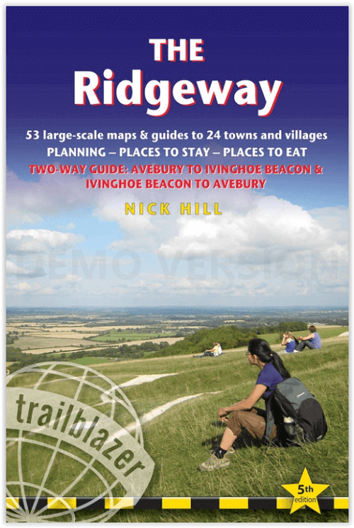
Wandelgids The Ridgeway National trail - Trailblazer
From Overton Hill near Avebury in Wiltshire to Ivinghoe Beacon
Korte omschrijving
The Ridgeway National trail - Trailblazer Productomschrijving: De Ridgeway national trail is een nationaal pad van 139 km, die loopt van Overton Hill bij Avebury in Wiltshire naar Ivinghoe B...

Specificaties
- Uitgever: Trailblazer Publications
- ISBN-13: 9781912716203
- HOOFDCATEGORIEËN: Wandelgids
- Activiteiten: Wandelen, Hiking & Trekking
- Auteur: Nick Hill
- Regio: Berkshire South West England, Buckinghamshire, England, Wiltshire, West England
- Land: England
- Lange afstand wandelroutes: Ridgeway National Trail (139 km)
- AONB - Area of Outstanding Beauty: Chiltern Hills AONB, North Wessex Downs AONB
- Blz.: 216
- Afmeting: 12x18
- Editie: 5
- Taal: Engels
Volledige omschrijving
The Ridgeway National trail - Trailblazer
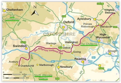
Productomschrijving: De Ridgeway national trail is een nationaal pad van 139 km, die loopt van Overton Hill bij Avebury in Wiltshire naar Ivinghoe Beacon in Buckinghamshire. Een deel van deze route volgt de oudste weg van Groot-Brittannië, die duizenden jaren oud is. Deze wandeling van 5-7 dagen is niet moeilijk en de beloning is talrijk: glooiend landschap, forten uit de ijzertijd, neolithische grafheuvels, witte paarden die in de krijtrotsen zijn uitgehouwen en pittoreske dorpjes. Met overnachtingsmogelijkheden, pubs en restaurants in gedetailleerde gidsen en kaarten van 24 steden en dorpen, waaronder Marlborough en Avebury.
Engelse omschrijving: An 87-mile (139km) National Trail, the Ridgeway runs from Overton Hill near Avebury in Wiltshire to Ivinghoe Beacon in Buckinghamshire. Part of this route follows Britain’s oldest road, dating back millennia. Taking 5-7 days, this is not a difficult walk and the rewards are many: rolling countryside, Iron Age forts, Neolithic burial mounds, white horses carved into the chalk downs and picturesque villages.
With accommodation, pubs and restaurants in detailed guides and maps to 24 towns and villages including Marlborough and Avebury.
The Ridgeway: Avebury to Ivinghoe Beacon
(British Walking Guide)
80 maps
46 colour photos,
4pp colour flower & butterfly guide
Includes 53 detailed walking maps
Unique mapping features
Itineraries for all walkers
Practical information for all budgets
Downloadable GPS waypoints
Locatie op kaart
Overzichtskaarten

Area's of Outstanding Natural Beauty - AONB's UK
Area's of Outstanding Natural Beauty - AONB's UK

Producten op de overzichtskaart
Klik op een product om naar de detailpagina te gaan.
- Wandelgids - Guide to the Cotswolds AONB - AA
- Wandelkaart 24 - Chilterns AONB - AA
- Fietskaart- en Mtb kaart - The Cotswolds - Goldeneye
- Wandelgids - Cotswold classic walks guidebook - Goldeneye
- Wandelkaart - Cotswold South AONB - Goldeneye
- Wandelgids - Exploring the Cotswolds - Goldeneye
- Wandelgids - Cotswold Classic Walks - Goldeneye
- Wandelkaart - Cotswolds- Malverns & Forest of Dean - Goldeneye
- Wandelgids - The Cotswold Way 30 classic routes - Cicerone
- Wandelgids - Kent walking guide - Cicerone
- Wandelgids - North Downs Way Nat. trail - Cicerone
- Wandelgids - Chilterns walking guide - Cicerone
- Wandelgids - Suffolk coast & Heaths walks - Cicerone
- Wandelgids - North Downs Way - Map Booklet - Cicerone
- Wandelgids - North Pennines AONB walking guide - Cicerone
- Wandelgids - Ridgeway National Trail - Cicerone
- Wandelgids - Forest of Bowland & Pendle - Cicerone
- Wandelgids - Hampshire's Test Way walking guide - Cicerone
- Wandelgids & Fietsgids - The Cotswold AONB - Cicerone
- Wandelgids - Walking on the Gower - Cicerone
- Wandelgids - North Wessex Downs - Cicerone Press
- Wandelgids - Walking on the North Wessex Downs - Cicerone
- Wandelgids - Silverdale & Arnside AONB - Cicerone
- Wandelgids - The Kennet and Avon Canal walking guide - Cicerone
- Wandelgids - North Downs Way- 246 km - Trailblazer
- Wandelkaart OL2 - Yorkshire Dales- Southern & Western Areas - OSI
- Wandelkaart OL19 - Howgill Fells and Upper Eden Valley - OSI
- Wandelkaart OL21 - South Pennines - Yorkshire - OSI
- Wandelkaart OL31 - North Pennines- Teesdale & Weardale - OSI
- Wandelkaart OL40 - The Broads - OSI
- Wandelkaart OL41 - Forest of Bowland & Ribblesdale - OSI
- Wandelkaart OL45 - The Cotswolds AONB- Gloucestershire - OSI
- Wandelkaart 108 - Lower Tamer Valley & Plymouth- Cornwall- OSI
- Wandelkaart 115 - Exmouth & Sidmouth- Devon - OSI
- Wandelkaart 137 - Ashford- Kent downs AONB- England - OSI
- Wandelkaart 140 - Quantock Hills AONB- Somerset - OSI
- Wandelkaart 140 - Quantock Hills AONB & Bridgwater- Devon - OSI
- Wandelkaart 147 - Sevenoaks & Tonbridge- Kent - OSI
- Wandelkaart 164 - Gower AONB & Gwyr- South Wales - OSI
- Wandelkaart 164 - Gower AONB & Gwyr- Wales - OSI
- Wandelkaart 171 - Chiltern Hills West & Henley-on-Thames OSI
- Wandelkaart 171 - Chiltern Hills West AONB- Wycombe - OSI
- Wandelkaart 172 - Chiltern Hills East AONB- Wycombe - OSI
- Wandelkaart 181 - Chiltern Hills AONB North- England - OSI
- Wandelkaart 181 - Chiltern Hills North AONB- Wycombe - OSI
- Wandelkaart 190 - Malvern Hills & Bredon Hill - OSI
- Wandelkaart 190 - Malvern Hills AONB & Bredon Hill - OSI
- Wandelkaart 203 - Ludlow- Shropshire Hills AONB - OSI
- Wandelkaart 217 - Long Mynd & Wenlock Edge- Schropshire- OSI
- Wandelkaart 254 - Lleyn Peninsular East- North Wales - OSI
- Wandelkaart 261 - Boston- Lincolnshire AONB - OSI
- Wandelkaart 262 - Anglesey West- Wales AONB - OSI
- Wandelkaart 263 - Anglesey East AONB- Wales - OSI
- Wandelkaart 273 - Lincolnshire Wolds South AONB - OSI
- Wandelkaart 282 - Lincolnshire Wolds North AONB - OSI
- Wandelkaart 298 - Nidderdale AONB- Yorkshire - OSI
- Wandelkaart 298 - Nidderdale AONB North Yorkshire - OSI
- Wandelkaart 300 - Howardian Hills AONB - OSI
- Wandelkaart 300 - Howardian Hills AONB & Malton - OSI
- Wandelkaart - Mourne Mountains N. Ireland - Harvey maps
- Wandelkaart - Fietskaart Forest of Bowland - Harvey maps
- Wandelkaart XT40 - Anglesey Coastal Path N. Wales - Harvey Maps
- Wandelkaart XT40 - Pennine Way Noord - Harvey Maps
- Wandelkaart XT40 - Pennine Way Zuid - Harvey Maps
- Wandelgids Cotswold - Way Two-way trekking guide - Knife Edge
- Reisgids Oxford & the Cotswolds AONB - Edicola
- Reisgids Cotswolds England - Rough Guides
- Reisgids Go Slow- Sussex & the South Downs- Weald & Coast - Bradt
- Travelguide Oxford & The Cotswolds pocket guide - Lonely Planet
- Wandelgids - The Ridgeway National trail - Trailblazer
Artikelen uit dezelfde regio

Wandelkaart 158 Newbury & Hungerford Berkshire - OSI • 9780319243510
Wandelkaart Newbury & Hungerford - Berkshire England Omvat ook: Lambourn & Kintbury Productomschrijving: Kaart nummer 158 in de OS Explorer kaarten reeks omvat de streek rond Newbury en de North Wessex Downs AONB - Area of Outstanding Natural Beauty. De Lambourn Valley Way loopt van Newbury tot Lambourn noordwaarts naar langs de rivier Lambourn. Andere hoogtepunten van het gebied zijn …

Wandelkaart 130 Salisburry & Stonehenge Wiltshire - OSI • 9780319243268
Wandelkaart Salisbury & Stonehenge - Wiltshire England Omvat ook: Wilton & Market Lavington. Productbeschrijving: Explorer kaart 130 omvat Salisbury en Wilton in het zuiden tot Market Lavington en Pewsey, in het noorden, en dekt delen van de North Wessex Downs, de Cranborne Chase & West Wiltshire Downs gebieden van uitzonderlijke natuurlijke schoonheid AONB evenals Stonehenge. Ook aanw…

Wandelkaart 156 Chippenham & Bradford-on-Avon - OSI • 9780319243497
Wandelkaart Chippenham & Bradford-on-Avon - Wiltshire Productbeschrijving: Trowbridge & Melksham. 156 / Chippenham & Bradford-on-Avon, wiltshire, England - Kaart nummer 156 in de OS Explorer reeks heeft betrekking op een gedeelte van de North Wessex Downs AONB en Cotswolds rond Melksham en Bradford-on-Avon. Hoogtepunten van het gebied zijn de steden Chippenham en Trowbridge samen met …

Wandelkaart Cotswold South AONB - Goldeneye • 9781859652541
Wandelkaart Cotswold South - Goldeneye Productomschrijving: Verken de zuidelijke Cotswolds AONB, met deze waterdichte Cotswolds-wandelkaart. Met 10 cirkelvormige rondwandelingen en duidelijk gemarkeerde routes zal deze gebruiksvriendelijke kaart u helpen de Cotswolds te ontdekken. Stap in de Cotswolds met deze uitzonderlijk mooie wandelingen. Ontdek idyllische honingkleurige stenen dorpjes…

Wandelkaart 173 Swindon- Devizes & Marlborough - OSI • 9780319474969
Wandelkaart Swindon- Devizes & Marlborough - Witlshire De OS Landranger kaarten reeks heeft betrekking op Groot-Brittannië met 204 gedetailleerde kaarten, perfect voor dagtochten en korte pauzes. Elke kaart bevat alle informatie die u nodig heeft om dit lokaal gebied te leren kennen en omvat plaatsen van belang, toeristische informatie, picknickplaatsen en campings, plus doorgangsrechten i…