

Wandelgids - North Downs Way Nat. trail - Cicerone
208 km lang van Farnham tot Dover


Korte omschrijving
Wandelgidsen South & South East England van CICERONE Press. Ideaal voor tochten in England.
Wandelgids North Downs Way Nat. trail - Cicerone Productomschrijving: Een wandelgids over de North Downs Way nationale Trail, een parcours van de 130 mijl (208km) tussen Farnham en Dover, me...

Specificaties
- Uitgever: CICERONE Press
- ISBN-13: 9781852848613
- HOOFDCATEGORIEËN: Wandelgids
- Activiteiten: Wandelen, Hiking & Trekking
- Regio: South & South East England
- Land: England
- Lange afstand wandelroutes: North Downs Way (246 km)
- AONB - Area of Outstanding Beauty: Kent Downs AONB, Surrey Hills AONB
- Schaal: 1:25000
- Editie: 3
- Taal: Engels
- National Trails UK, England & Wales: North Downs Way, England
Volledige omschrijving
Wandelgids North Downs Way Nat. trail - Cicerone
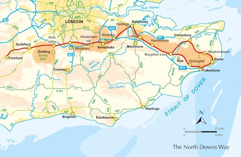
Productomschrijving: Een wandelgids over de North Downs Way nationale Trail, een parcours van de 130 mijl (208km) tussen Farnham en Dover, met een optioneel bezoek aan de Canterbury. Naar aanleiding van de grotendeelse oude pelgrimsroute, door aangenaam platteland, dit is een van de éénvoudigere nationale routes waar de wandeling over 11 etappes in wordt beschreven. Met 1:25K OS kaart boekje.
Product description: Guidebook to walking the North Downs Way National Trail, a 130 mile (208km) trail between Farnham and Dover, with an optional visit to Canterbury. Following the ancient Pilgrim's Way for much of the way, through pleasant countryside, this is one of the easier National Trails and the walk is described over 11 stages. With 1:25K OS map booklet.
Seasons:
The North Downs Way can be walked at any time of the year, but is seen at its best between April and October.
Centres:
Beginning in Farnham, the North Downs Way passes close-to or through Guildford, Otford, Wrotham, Detling, Charing, Wye, Chilham, Canterbury, Patrixbourne and ends in Dover.
Difficulty:
Despite some reasonably short steep ascents and descents, the North Downs Way is one of the more gentle of National Trails and is suitable for first-time long distance walkers.
Must See:
Passing through the Surrey and Kent Downs Areas of Outstanding Natural Beauty, the North Downs Way crosses Box Hill, visits Neolithic sites like the Coldrum Stones and Kits Coty House; passes below the remains of Thurnham Castle, visits Canterbury Cathedral, Dover Castle, and across Shakespeare Cliff, one of the White Cliffs of Dover.

Locatie op kaart
Overzichtskaarten

Area's of Outstanding Natural Beauty - AONB's UK
Area's of Outstanding Natural Beauty - AONB's UK

Producten op de overzichtskaart
Klik op een product om naar de detailpagina te gaan.
- Wandelgids - Guide to the Cotswolds AONB - AA
- Wandelkaart 24 - Chilterns AONB - AA
- Wandelgids - Cotswold classic walks guidebook - Goldeneye
- Wandelgids - Cotswold Classic Walks - Goldeneye
- Wandelgids - The Cotswold Way 30 classic routes - Cicerone
- Wandelgids - North Downs Way Nat. trail - Cicerone
- Wandelgids - Chilterns walking guide - Cicerone
- Wandelgids - Suffolk coast & Heaths walks - Cicerone
- Wandelgids - North Downs Way - Map Booklet - Cicerone
- Wandelgids - North Pennines AONB walking guide - Cicerone
- Wandelgids - Ridgeway National Trail - Cicerone
- Wandelgids - Forest of Bowland & Pendle - Cicerone
- Wandelgids - Hampshire's Test Way walking guide - Cicerone
- Wandelgids & Fietsgids - The Cotswold AONB - Cicerone
- Wandelgids - North Wessex Downs - Cicerone Press
- Wandelgids - Walking on the North Wessex Downs - Cicerone
- Wandelgids - Silverdale & Arnside AONB - Cicerone
- Wandelkaart OL2 - Yorkshire Dales- Southern & Western Areas - OSI
- Wandelkaart OL19 - Howgill Fells and Upper Eden Valley - OSI
- Wandelkaart OL21 - South Pennines - Yorkshire - OSI
- Wandelkaart OL31 - North Pennines- Teesdale & Weardale - OSI
- Wandelkaart OL40 - The Broads - OSI
- Wandelkaart OL41 - Forest of Bowland & Ribblesdale - OSI
- Wandelkaart OL45 - The Cotswolds AONB- Gloucestershire - OSI
- Wandelkaart 108 - Lower Tamer Valley & Plymouth- Cornwall- OSI
- Wandelkaart 115 - Exmouth & Sidmouth- Devon - OSI
- Wandelkaart 137 - Ashford- Kent downs AONB- England - OSI
- Wandelkaart 140 - Quantock Hills AONB- Somerset - OSI
- Wandelkaart 140 - Quantock Hills AONB & Bridgwater- Devon - OSI
- Wandelkaart 147 - Sevenoaks & Tonbridge- Kent - OSI
- Wandelkaart 164 - Gower AONB & Gwyr- South Wales - OSI
- Wandelkaart 164 - Gower AONB & Gwyr- Wales - OSI
- Wandelkaart 171 - Chiltern Hills West & Henley-on-Thames OSI
- Wandelkaart 171 - Chiltern Hills West AONB- Wycombe - OSI
- Wandelkaart 172 - Chiltern Hills East AONB- Wycombe - OSI
- Wandelkaart 181 - Chiltern Hills AONB North- England - OSI
- Wandelkaart 181 - Chiltern Hills North AONB- Wycombe - OSI
- Wandelkaart 190 - Malvern Hills & Bredon Hill - OSI
- Wandelkaart 190 - Malvern Hills AONB & Bredon Hill - OSI
- Wandelkaart 203 - Ludlow- Shropshire Hills AONB - OSI
- Wandelkaart 217 - Long Mynd & Wenlock Edge- Schropshire- OSI
- Wandelkaart 254 - Lleyn Peninsular East- North Wales - OSI
- Wandelkaart 261 - Boston- Lincolnshire AONB - OSI
- Wandelkaart 262 - Anglesey West- Wales AONB - OSI
- Wandelkaart 263 - Anglesey East AONB- Wales - OSI
- Wandelkaart 273 - Lincolnshire Wolds South AONB - OSI
- Wandelkaart 282 - Lincolnshire Wolds North AONB - OSI
- Wandelkaart 298 - Nidderdale AONB- Yorkshire - OSI
- Wandelkaart 298 - Nidderdale AONB North Yorkshire - OSI
- Wandelkaart 300 - Howardian Hills AONB - OSI
- Wandelkaart 300 - Howardian Hills AONB & Malton - OSI
- Wandelkaart - Mourne Mountains N. Ireland - Harvey maps
- Wandelkaart - Fietskaart Forest of Bowland - Harvey maps
- Wandelkaart XT40 - Anglesey Coastal Path N. Wales - Harvey Maps
- Wandelkaart XT40 - Pennine Way Noord - Harvey Maps
- Wandelkaart XT40 - Pennine Way Zuid - Harvey Maps
- Wandelgids Cotswold - Way Two-way trekking guide - Knife Edge
- Reisgids Cotswolds England - Rough Guides
Artikelen uit dezelfde regio

Wandelkaart XT40 South West Coast Path 1 - Harvey maps • 9781851375547
Wandelkaart - South West Coast Path 1 - XT40 - Harvey maps Productomschrijving: Een wandelkaart die het zuidelijk deel beschrijft van het LAW wandelpad in de regio Devon / Cornwall, van Minehead tot St-Ives. De route telt in zijn geheel maar liefst 1014km lange wandelpad, genaamd "West Coast Path". De gehele route werd opgesplitst in 3 delen, De ISBN nrs van alle drie de kaarten zijn hiero…

Mountainbikegids South Downs - 26 off road routes - Cicerone • 9781852846459
Mountainbikegids South Downs - 26 off road routes - Cicerone Productomschrijving: Een gids voor berg (MTB) fietsroutes op de South Downs van Hampshire en Sussex, tussen Winchester, Brighton en Eastbourne. De 26 routes beschreven in dit boek nemen deel aan achtbanen, toegewijde bos singletrack en grote afdalingen. Ritten worden gequoteerd voor alle vaardigheden met informatie over plaatseli…
Reisgids Country guide Sud de l'Angleterre - Petit Futé • 9782305122274
Reisgids Sud de l'Angleterre - Petit Futé Productomschrijving: La série télévisée britannique à succès Broadchurch a jeté un coup de projecteur sur cette destination si proche de la France et qui n'a rien a envier à nos cotes normandes. Partir pour le Sud de l'Angleterre, c'est découvrir Londres, bien sur, mais aussi la Manche, située à quelques kilomètres de la capitale, et le Sussex…

Wandelkaart OL22 New Forest National Park - OS • 9780319263921
Wandelkaart New Forest National Park - OS Productomschrijving: New Forest National Park, Hampshire England. Omvat: Southampton, Ringwood, Ferndown, Lymington, Christchurch and Bournemouth, parts of the New Forest National Park. Ontdek de OL-serie van Ordnance Survey: De OL-serie (Outdoor Leisure) van Ordnance Survey is dé referentie voor wie gaat wandelen op de Britse eilanden. D…

Fietsgids 20 Rides in South East England - Cicerone • 9781852847432
Cycle the best Sportive routes in South East England Productomschrijving: Deze gids biedt 20 sportieve wielerroutes in de meest uitdagende en mooie fietsgebieden van Zuidoost-Engeland. Van Surrey en de Chiltern Hills naar het New Forest en de Berkshire Downs, het gebied heeft km's van fietsvriendelijke wegen geschikt voor sportieve training. De gesorteerde routes zijn allemaal op rustige l…