

Wandelgids - Ridgeway National Trail - Cicerone
Avebury in Wiltshire to Ivinghoe Beacon in Buckinghamshire


Korte omschrijving
Wandelgidsen South & South East England van CICERONE Press. Ideaal voor tochten in England.
Wandelgids The Ridgeway National Trail 139 km - Cicerone Productomschrijving: Gids voor de beroemde Ridgeway National Trail, een route van 139 km door het zuiden van Engeland, van Avebury in...

Specificaties
- Uitgever: CICERONE Press
- ISBN-13: 9781852848743
- HOOFDCATEGORIEËN: Wandelgids
- Activiteiten: Wandelen, Hiking & Trekking
- Auteur: Steve Davison
- Regio: South & South East England
- Land: England
- Lange afstand wandelroutes: Ridgeway National Trail (139 km)
- AONB - Area of Outstanding Beauty/National Landscape: Chiltern Hills AONB, North Wessex Downs AONB
- Editie: 2
- Taal: Engels
- National Trails UK, England & Wales: The RidgeWay, England
Volledige omschrijving
Wandelgids The Ridgeway National Trail 139 km - Cicerone
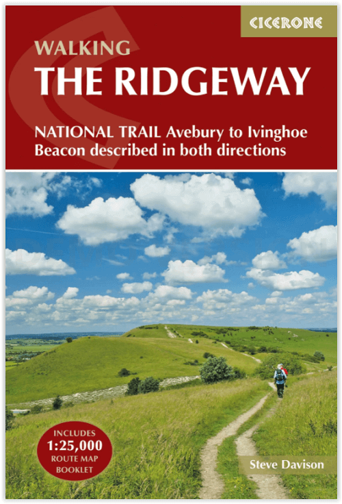
Productomschrijving: Gids voor de beroemde Ridgeway National Trail, een route van 139 km door het zuiden van Engeland, van Avebury in Wiltshire naar Ivinghoe Beacon in Buckinghamshire. Deze gids, die vergezeld gaat van een 1:25K kaartboekje, beschrijft de route in beide richtingen en bevat informatie over historische plaatsen en faciliteiten langs de route.
Engelse omschrijving: Guidebook to the Ridgeway National Trail, an 87 mile (139km) route through the south of England from Avebury in Wiltshire to Ivinghoe Beacon in Buckinghamshire. Accompanied by a pull-out 1:25K mapping booklet, this guidebook details the trail in both directions and features information on historic sites and facilities along the way.
Seasons:
Scan be undertaken at any time of the year, although the weather and ground conditions are better from spring through to the end of autumn (from colourful displays of flowers in spring to the dramatic tree colours of autumn); a frosty or snowy day on the Ridgeway can be magical - but daylight hours are shorter.
Centres:
Avebury, Swindon, Marlborough, Wantage, Streatley, Goring, Wallingford, Watlington, Chinnor, Princes Risborough, Wendover and Tring.
Difficulty:
A fairly low-level (never going above 300m) waymarked walk that follows mostly good tracks and paths, suitable for all abilities.
Must See:
Two contrasting AONBs: the wide open, chalky North Wessex Downs and the more wooded, intimate landscape of the Chilterns; the stone circle at Avebury to Wayland's Smithy Neolithic burial mound and the Uffington White Horse; great views, short excursions to picturesque towns and villages.

Stage 1 Overton Hill (Avebury) to Ogbourne St George
Stage 2 Ogbourne St George to Ashbury Folly
Stage 3 Ashbury Folly to the A338 (Wantage/Court Hill Centre)
Stage 4 A338 (Wantage/Court Hill Centre) to Bury Down
Stage 5 Bury Down to Streatley
Stage 6 Streatley to Mongewell Park
Stage 7 Mongewell Park to Watlington
Stage 8 Watlington to Chinnor
Stage 9 Chinnor to Princes Risborough
Stage 10 Princes Risborough to Wendover
Stage 11 Wendover to Wigginton
Stage 12 Wigginton to Ivinghoe Beacon
The Ridgeway (East to West)
Stage 1 Ivinghoe Beacon to Wigginton
Stage 2 Wigginton to Wendover
Stage 3 Wendover to Princes Risborough
Stage 4 Princes Risborough to Chinnor
Stage 5 Chinnor to Watlington
Stage 6 Watlington to Mongewell Park
Stage 7 Mongewell Park to Streatley
Stage 8 Streatley to Bury Down
Stage 9 Bury Down to the A338 (Wantage/Court Hill Centre)
Stage 10 A338 (Wantage/Court Hill Centre) to Ashbury Folly
Stage 11 Ashbury Folly to Ogbourne St George
Stage 12 Ogbourne St George to Overton Hill (Avebury)
Locatie op kaart
Overzichtskaarten

Area's of Outstanding Natural Beauty - AONB's UK
Area's of Outstanding Natural Beauty - AONB's UK

Producten op de overzichtskaart
Klik op een product om naar de detailpagina te gaan.
- Wandelgids - Guide to the Cotswolds AONB - AA
- Wandelkaart 24 - Chilterns AONB - AA
- Wandelgids - Cotswold classic walks guidebook - Goldeneye
- Wandelgids - Cotswold Classic Walks - Goldeneye
- Wandelgids - The Cotswold Way 30 classic routes - Cicerone
- Wandelgids - North Downs Way Nat. trail - Cicerone
- Wandelgids - Chilterns walking guide - Cicerone
- Wandelgids - Suffolk coast & Heaths walks - Cicerone
- Wandelgids - North Downs Way - Map Booklet - Cicerone
- Wandelgids - North Pennines AONB walking guide - Cicerone
- Wandelgids - Ridgeway National Trail - Cicerone
- Wandelgids - Forest of Bowland & Pendle - Cicerone
- Wandelgids - Hampshire's Test Way walking guide - Cicerone
- Wandelgids & Fietsgids - The Cotswold AONB - Cicerone
- Wandelgids - North Wessex Downs - Cicerone Press
- Wandelgids - Walking on the North Wessex Downs - Cicerone
- Wandelgids - Silverdale & Arnside AONB - Cicerone
- Wandelkaart OL2 - Yorkshire Dales- Southern & Western Areas - OSI
- Wandelkaart OL19 - Howgill Fells and Upper Eden Valley - OSI
- Wandelkaart OL21 - South Pennines - Yorkshire - OSI
- Wandelkaart OL31 - North Pennines- Teesdale & Weardale - OSI
- Wandelkaart OL40 - The Broads - OSI
- Wandelkaart OL41 - Forest of Bowland & Ribblesdale - OSI
- Wandelkaart OL45 - The Cotswolds AONB- Gloucestershire - OSI
- Wandelkaart 108 - Lower Tamer Valley & Plymouth- Cornwall- OSI
- Wandelkaart 115 - Exmouth & Sidmouth- Devon - OSI
- Wandelkaart 137 - Ashford- Kent downs AONB- England - OSI
- Wandelkaart 140 - Quantock Hills AONB- Somerset - OSI
- Wandelkaart 140 - Quantock Hills AONB & Bridgwater- Devon - OSI
- Wandelkaart 147 - Sevenoaks & Tonbridge- Kent - OSI
- Wandelkaart 164 - Gower AONB & Gwyr- South Wales - OSI
- Wandelkaart 164 - Gower AONB & Gwyr- Wales - OSI
- Wandelkaart 171 - Chiltern Hills West & Henley-on-Thames OSI
- Wandelkaart 171 - Chiltern Hills West AONB- Wycombe - OSI
- Wandelkaart 172 - Chiltern Hills East AONB- Wycombe - OSI
- Wandelkaart 181 - Chiltern Hills AONB North- England - OSI
- Wandelkaart 181 - Chiltern Hills North AONB- Wycombe - OSI
- Wandelkaart 190 - Malvern Hills & Bredon Hill - OSI
- Wandelkaart 190 - Malvern Hills AONB & Bredon Hill - OSI
- Wandelkaart 203 - Ludlow- Shropshire Hills AONB - OSI
- Wandelkaart 217 - Long Mynd & Wenlock Edge- Schropshire- OSI
- Wandelkaart 254 - Lleyn Peninsular East- North Wales - OSI
- Wandelkaart 261 - Boston- Lincolnshire AONB - OSI
- Wandelkaart 262 - Anglesey West- Wales AONB - OSI
- Wandelkaart 263 - Anglesey East AONB- Wales - OSI
- Wandelkaart 273 - Lincolnshire Wolds South AONB - OSI
- Wandelkaart 282 - Lincolnshire Wolds North AONB - OSI
- Wandelkaart 298 - Nidderdale AONB- Yorkshire - OSI
- Wandelkaart 298 - Nidderdale AONB North Yorkshire - OSI
- Wandelkaart 300 - Howardian Hills AONB - OSI
- Wandelkaart 300 - Howardian Hills AONB & Malton - OSI
- Wandelkaart - Mourne Mountains N. Ireland - Harvey maps
- Wandelkaart - Fietskaart Forest of Bowland - Harvey maps
- Wandelkaart XT40 - Anglesey Coastal Path N. Wales - Harvey Maps
- Wandelkaart XT40 - Pennine Way Noord - Harvey Maps
- Wandelkaart XT40 - Pennine Way Zuid - Harvey Maps
- Wandelgids Cotswold - Way Two-way trekking guide - Knife Edge
- Reisgids Cotswolds England - Rough Guides
Artikelen uit dezelfde regio
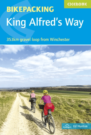
Fietsgids Bikepackin The King Alfred's Way - Cicerone • 9781786312389
Fietsgids Bikepackin King Alfred's Way - Cicerone Productomschrijving: A practical and inspiring guidebook to bikepacking King Alfred’s Way, a 353km circular route through southern England that weaves together ancient trackways, rolling chalk downs and quiet rural lanes. Riding through landscapes shaped by thousands of years of history, the route links some of the most iconic off-road trai…

Wandelgids Thames Valley walking guide - Cicerone • 9781852845704
Wandelgids - Thames Valley walking guide - Cicerone Productomschrijving: Deze handige gids biedt 25 avontuurlijke dagwandelingen in de Thames Valley, die betrekking hebben op de North Hampshire Downs, Berkshire en de zuidelijke Chilterns met gemakkelijke toegang tot Londen. De circulaire wandelingen variëren van 10 tot 18 mijl, waaronder een twee-daagse trot, evenals kortere route opties v…

Wandelkaart XT40 South West Coast Path 1 - Harvey maps • 9781851375547
Wandelkaart - South West Coast Path 1 - XT40 - Harvey maps Productomschrijving: Een wandelkaart die het zuidelijk deel beschrijft van het LAW wandelpad in de regio Devon / Cornwall, van Minehead tot St-Ives. De route telt in zijn geheel maar liefst 1014km lange wandelpad, genaamd "West Coast Path". De gehele route werd opgesplitst in 3 delen, De ISBN nrs van alle drie de kaarten zijn hiero…
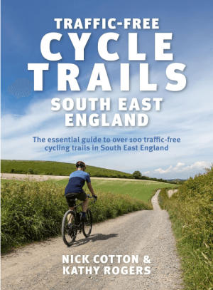
Fietsgids Traffic-Free Cycle Trails S.E. England - Vertebrate • 9781839811647
Traffic-Free Cycle Trails South East England - Vertebrate Productomschrijving: The essential guide to over 100 traffic-free cycling trails in South East England. Traffic-Free Cycle Trails South East England by Nick Cotton and Kathy Rogers features over 100 great cycling routes across the South East, London and into Eastern England. A companion guide to Nick Cotton’s bestselling Traffi…

Wandelgids The Kennet and Avon Canal walk - Cicerone • 9781786312303
The Kennet and Avon Canal walk - Cicerone Productomschrijving: Wandelgids langs het Kennet & Avon kanaal. De 151 Km lange route van Reading naar Bristol is verdeeld in 7 etappes van redelijk gemakkelijke wandelingen en omvat het UNESCO werelderfgoed Bath en de drijvende haven van Bristol. Er zijn ook 20 rondwandelingen opgenomen, variërend van 4¼ tot 9 mijl, waarbij de beste delen van het …