
Wandelgids Kent walking guide - Cicerone
Een wandelgids met 40 wandelingen in het graafschap Kent

Korte omschrijving
Wandelgids - Kent walking guide - Cicerone Productomschrijving: Een wandelgids met beschrijvingen van 40 wandelingen in het graafschap Kent. Met betrekking tot west Kent en de Weald en Noord...

Specificaties
- Uitgever: CICERONE Press
- ISBN-13: 9781852848620
- HOOFDCATEGORIEËN: Wandelgids
- Activiteiten: Wandelen, Hiking & Trekking
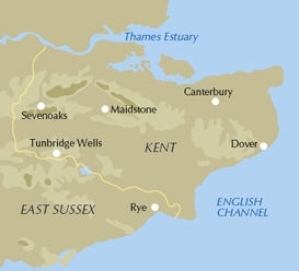
- Regio: Kent South East England
- Land: England
- AONB - Area of Outstanding Beauty: Kent Downs AONB
- Blz.: 240
- Afmeting: 12x17
- Editie: 4
- Taal: Engels
Volledige omschrijving
Wandelgids - Kent walking guide - Cicerone
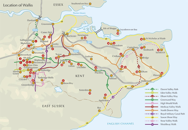
Productomschrijving: Een wandelgids met beschrijvingen van 40 wandelingen in het graafschap Kent. Met betrekking tot west Kent en de Weald en Noord- en Oost-Kent, met inbegrip van de Kent Downs en de Greensand hills. Wandelingen van 5 tot en met 9 mijl verkennen rivieren en kustlijn, prachtige natuur en historische dorpen. Met contouren van 11 langere wandelingen, variërend van 15 tot 163 mijl.
Engelse omschrijving: A guidebook describing 40 walks in the county of Kent. Covering west Kent and The Weald and north and east Kent, including the Kent Downs and the Greensand Hills. Walks of 5 to 9 miles explore rivers and coastline, beautiful countryside and historic villages. With outlines of 11 longer walks ranging from 15 to 163 miles.

Locatie op kaart
Overzichtskaarten

Area's of Outstanding Natural Beauty - AONB's UK
Area's of Outstanding Natural Beauty - AONB's UK

Producten op de overzichtskaart
Klik op een product om naar de detailpagina te gaan.
- Wandelgids - Guide to the Cotswolds AONB - AA
- Wandelkaart 24 - Chilterns AONB - AA
- Fietskaart- en Mtb kaart - The Cotswolds - Goldeneye
- Wandelgids - Cotswold classic walks guidebook - Goldeneye
- Wandelkaart - Cotswold South AONB - Goldeneye
- Wandelgids - Exploring the Cotswolds - Goldeneye
- Wandelgids - Cotswold Classic Walks - Goldeneye
- Wandelkaart - Cotswolds- Malverns & Forest of Dean - Goldeneye
- Wandelgids - The Cotswold Way 30 classic routes - Cicerone
- Wandelgids - Kent walking guide - Cicerone
- Wandelgids - North Downs Way Nat. trail - Cicerone
- Wandelgids - Chilterns walking guide - Cicerone
- Wandelgids - Suffolk coast & Heaths walks - Cicerone
- Wandelgids - North Downs Way - Map Booklet - Cicerone
- Wandelgids - North Pennines AONB walking guide - Cicerone
- Wandelgids - Ridgeway National Trail - Cicerone
- Wandelgids - Forest of Bowland & Pendle - Cicerone
- Wandelgids - Hampshire's Test Way walking guide - Cicerone
- Wandelgids & Fietsgids - The Cotswold AONB - Cicerone
- Wandelgids - Walking on the Gower - Cicerone
- Wandelgids - North Wessex Downs - Cicerone Press
- Wandelgids - Walking on the North Wessex Downs - Cicerone
- Wandelgids - Silverdale & Arnside AONB - Cicerone
- Wandelgids - The Kennet and Avon Canal walking guide - Cicerone
- Wandelgids - North Downs Way- 246 km - Trailblazer
- Wandelkaart OL2 - Yorkshire Dales- Southern & Western Areas - OSI
- Wandelkaart OL19 - Howgill Fells and Upper Eden Valley - OSI
- Wandelkaart OL21 - South Pennines - Yorkshire - OSI
- Wandelkaart OL31 - North Pennines- Teesdale & Weardale - OSI
- Wandelkaart OL40 - The Broads - OSI
- Wandelkaart OL41 - Forest of Bowland & Ribblesdale - OSI
- Wandelkaart OL45 - The Cotswolds AONB- Gloucestershire - OSI
- Wandelkaart 108 - Lower Tamer Valley & Plymouth- Cornwall- OSI
- Wandelkaart 115 - Exmouth & Sidmouth- Devon - OSI
- Wandelkaart 137 - Ashford- Kent downs AONB- England - OSI
- Wandelkaart 140 - Quantock Hills AONB- Somerset - OSI
- Wandelkaart 140 - Quantock Hills AONB & Bridgwater- Devon - OSI
- Wandelkaart 147 - Sevenoaks & Tonbridge- Kent - OSI
- Wandelkaart 164 - Gower AONB & Gwyr- South Wales - OSI
- Wandelkaart 164 - Gower AONB & Gwyr- Wales - OSI
- Wandelkaart 171 - Chiltern Hills West & Henley-on-Thames OSI
- Wandelkaart 171 - Chiltern Hills West AONB- Wycombe - OSI
- Wandelkaart 172 - Chiltern Hills East AONB- Wycombe - OSI
- Wandelkaart 181 - Chiltern Hills AONB North- England - OSI
- Wandelkaart 181 - Chiltern Hills North AONB- Wycombe - OSI
- Wandelkaart 190 - Malvern Hills & Bredon Hill - OSI
- Wandelkaart 190 - Malvern Hills AONB & Bredon Hill - OSI
- Wandelkaart 203 - Ludlow- Shropshire Hills AONB - OSI
- Wandelkaart 217 - Long Mynd & Wenlock Edge- Schropshire- OSI
- Wandelkaart 254 - Lleyn Peninsular East- North Wales - OSI
- Wandelkaart 261 - Boston- Lincolnshire AONB - OSI
- Wandelkaart 262 - Anglesey West- Wales AONB - OSI
- Wandelkaart 263 - Anglesey East AONB- Wales - OSI
- Wandelkaart 273 - Lincolnshire Wolds South AONB - OSI
- Wandelkaart 282 - Lincolnshire Wolds North AONB - OSI
- Wandelkaart 298 - Nidderdale AONB- Yorkshire - OSI
- Wandelkaart 298 - Nidderdale AONB North Yorkshire - OSI
- Wandelkaart 300 - Howardian Hills AONB - OSI
- Wandelkaart 300 - Howardian Hills AONB & Malton - OSI
- Wandelkaart - Mourne Mountains N. Ireland - Harvey maps
- Wandelkaart - Fietskaart Forest of Bowland - Harvey maps
- Wandelkaart XT40 - Anglesey Coastal Path N. Wales - Harvey Maps
- Wandelkaart XT40 - Pennine Way Noord - Harvey Maps
- Wandelkaart XT40 - Pennine Way Zuid - Harvey Maps
- Wandelgids Cotswold - Way Two-way trekking guide - Knife Edge
- Reisgids Oxford & the Cotswolds AONB - Edicola
- Reisgids Cotswolds England - Rough Guides
- Reisgids Go Slow- Sussex & the South Downs- Weald & Coast - Bradt
- Travelguide Oxford & The Cotswolds pocket guide - Lonely Planet
- Wandelgids - The Ridgeway National trail - Trailblazer
Artikelen uit dezelfde regio

Wandelkaart 138 Dover Folkstone & Hythe Kent England - OSI • 9780319470107
Wandelkaart Dover- Folkstone & Hythe - Kent England - OSI Productbeschrijving: In het verre zuidoosten van Engeland, Dover, Folkstone en Hythe, grenst aan de Kent Downs, en Area of Outstanding Natural Beauty AONB. U kunt de beroemde White Cliffs of Dover zien, of verder landinwaarts gaan en traditionele dorpen en glooiende heuvels ontdekken. Dit gebied omvat ook een deel van de North Down…

Wandelkaart 125 Romney Marsh Rye & Winchelsea - OSI • 9780319243213
Wandelkaart Romney Marsh- Rye & Winchelsea - OSI Omvat ook: Rye & Winchelsea Tenterden & New Romney. Productbeschrijving: Kaart nummer 125 in de OS Explorer kaarten reeks omvat High Weald tussen East Sussex en Kent aan de zuidkust van Engeland. De kaart beslaat een gebied van Tenterden, New Romney en Rye en omvat wandelingen zoals de Saxon Shore Way, die ook de 1066 country en Sussex g…

Wandelkaart 149 Sittingbourne & Faversham- Kent - OSI • 9780319243428
Wandelkaart Sittingbourne & Faversham - Kent England Omvat ook: Isle of Sheppey Productbeschrijving: OS Explorer Kaart 149 omvat de Kent Downs AONB en het eiland Sheppey. Dit laaggelegen gebied heeft een aantal natuurreservaten, plus de Swale Heritage Trail. De OS Explorer kaart voor Sittingbourne & Faversham is beschikbaar in zowel de standaard papieren versie als de weerbestendige 'A…

Wandelgids North Downs Way- 246 km - Trailblazer • 9781905864904
The 246 km long North Downs Way - Trailblazer Productomschrijving: The North Downs Way, is een lange afstand route van om en bij de 246 km. Een meerdaagse wandelroute in het zuiden van Engeland zeg maar. Het loopt van Farnham tot Dover, lags Guildford, Dorking, Merstham, Otford & Rochester, lags de Surrey Hills "Area of Outstanding Natural Beauty" (AONB) and Kent Downs AONB. De route besta…

Wandelkaart 136 High Weald Royal Tunbridge Wells - OSI • 9780319243299
Wandelkaart High Weald - Royal Tunbridge Wells - Kent - OSI Productomschrijving: Royal Tunbridge Wells, doorgaans afgekort tot Tunbridge Wells is een plaats in het bestuurlijke gebied Tunbridge Wells, in het Engelse graafschap Kent. 136 / High Weald / Royal Tunbridge Wells, Kent, England - Kaart nummer 136 is een all purpose kaart vol gepakt met informatie om u het gebied te helpen ler…