
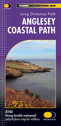
Wandelkaart XT40 Anglesey Coastal Path N. Wales - Harvey Maps
Loopt langs de kust van dit uitermate geschikt wandeleiland
Korte omschrijving
Wandelkaart XT40 - Anglesey Coastal Path N. Wales - Harvey Maps Productomschrijving: Anglesey, is een eiland en bestuurlijk graafschap aan de noordwestkust van Wales. Het vormt een onderdeel...

Specificaties
- Uitgever: HARVEY MAPS
- ISBN-13: 9781851375851
- HOOFDCATEGORIEËN: Wandelkaart
- Activiteiten: Wandelen, Hiking & Trekking
- Regio: North Wales
- Land: Wales
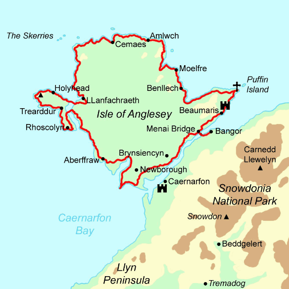
- Lange afstand wandelroutes: The Isle of Anglesey Coastal Path (200 km)
- AONB - Area of Outstanding Beauty: The Isle of Anglesey Coastal Path - AONB
- Schaal: 1:40000
- Afmeting: 14x25
- Taal: Engels
Volledige omschrijving
Wandelkaart XT40 - Anglesey Coastal Path N. Wales - Harvey Maps
Productomschrijving: Anglesey, is een eiland en bestuurlijk graafschap aan de noordwestkust van Wales. Het vormt een onderdeel van het ceremoniële behouden graafschap Gwynedd en is tevens een historisch graafschap. Deze kaart brengt u per wandelpad langs de kust van dit uitermate geschikt wandeleiland
Nieuwe generatie HARVEY Superwalker, XT25 waterproof, werden ontworpen om de meest praktische tools te zijn voor GPS-navigatie. Het formaat geeft meer toewijzingen op het blad zonder de kaart zwaarder en volumineuser te maken. De kaartvouw werd ontwikkeld waarmee u direct naar elk deel en aan weerszijden van het blad, eenvoudig kan bladeren zonder te moeten vechten tegen de wind. De Superwalker-XT25 is gebaseerd op de originele HARVEY mapping, met alle informatie die een wandelaar zou verwachten op een kaart van schaal 1: 25.000. Het geheel van de Arran coast Route wordt ook getoond op deze kaart.
De duidelijkheid van de toewijzingen zijn verbeterd, zodat meer mensen zonder het gebruik van een bril zouden kunnen lezen. De kaart is rijk aan informatie, die relevant is voor de wandelaar. Ervaar de tevredenheid van fijne navigatie met de Superwalker XT25 serie, nu gedrukt op 100% waterdicht- en bijna onverwoestbaar papier, ongeacht het weer!
Locatie op kaart
Overzichtskaarten

Area's of Outstanding Natural Beauty - AONB's UK
Area's of Outstanding Natural Beauty - AONB's UK

Producten op de overzichtskaart
Klik op een product om naar de detailpagina te gaan.
- Wandelgids - Guide to the Cotswolds AONB - AA
- Wandelkaart 24 - Chilterns AONB - AA
- Fietskaart- en Mtb kaart - The Cotswolds - Goldeneye
- Wandelgids - Cotswold classic walks guidebook - Goldeneye
- Wandelkaart - Cotswold South AONB - Goldeneye
- Wandelgids - Exploring the Cotswolds - Goldeneye
- Wandelgids - Cotswold Classic Walks - Goldeneye
- Wandelkaart - Cotswolds- Malverns & Forest of Dean - Goldeneye
- Wandelgids - The Cotswold Way 30 classic routes - Cicerone
- Wandelgids - Kent walking guide - Cicerone
- Wandelgids - North Downs Way Nat. trail - Cicerone
- Wandelgids - Chilterns walking guide - Cicerone
- Wandelgids - Suffolk coast & Heaths walks - Cicerone
- Wandelgids - North Downs Way - Map Booklet - Cicerone
- Wandelgids - North Pennines AONB walking guide - Cicerone
- Wandelgids - Ridgeway National Trail - Cicerone
- Wandelgids - Forest of Bowland & Pendle - Cicerone
- Wandelgids - Hampshire's Test Way walking guide - Cicerone
- Wandelgids & Fietsgids - The Cotswold AONB - Cicerone
- Wandelgids - Walking on the Gower - Cicerone
- Wandelgids - North Wessex Downs - Cicerone Press
- Wandelgids - Walking on the North Wessex Downs - Cicerone
- Wandelgids - Silverdale & Arnside AONB - Cicerone
- Wandelgids - The Kennet and Avon Canal walking guide - Cicerone
- Wandelgids - North Downs Way- 246 km - Trailblazer
- Wandelkaart OL2 - Yorkshire Dales- Southern & Western Areas - OSI
- Wandelkaart OL19 - Howgill Fells and Upper Eden Valley - OSI
- Wandelkaart OL21 - South Pennines - Yorkshire - OSI
- Wandelkaart OL31 - North Pennines- Teesdale & Weardale - OSI
- Wandelkaart OL40 - The Broads - OSI
- Wandelkaart OL41 - Forest of Bowland & Ribblesdale - OSI
- Wandelkaart OL45 - The Cotswolds AONB- Gloucestershire - OSI
- Wandelkaart 108 - Lower Tamer Valley & Plymouth- Cornwall- OSI
- Wandelkaart 115 - Exmouth & Sidmouth- Devon - OSI
- Wandelkaart 137 - Ashford- Kent downs AONB- England - OSI
- Wandelkaart 140 - Quantock Hills AONB- Somerset - OSI
- Wandelkaart 140 - Quantock Hills AONB & Bridgwater- Devon - OSI
- Wandelkaart 147 - Sevenoaks & Tonbridge- Kent - OSI
- Wandelkaart 164 - Gower AONB & Gwyr- South Wales - OSI
- Wandelkaart 164 - Gower AONB & Gwyr- Wales - OSI
- Wandelkaart 171 - Chiltern Hills West & Henley-on-Thames OSI
- Wandelkaart 171 - Chiltern Hills West AONB- Wycombe - OSI
- Wandelkaart 172 - Chiltern Hills East AONB- Wycombe - OSI
- Wandelkaart 181 - Chiltern Hills AONB North- England - OSI
- Wandelkaart 181 - Chiltern Hills North AONB- Wycombe - OSI
- Wandelkaart 190 - Malvern Hills & Bredon Hill - OSI
- Wandelkaart 190 - Malvern Hills AONB & Bredon Hill - OSI
- Wandelkaart 203 - Ludlow- Shropshire Hills AONB - OSI
- Wandelkaart 217 - Long Mynd & Wenlock Edge- Schropshire- OSI
- Wandelkaart 254 - Lleyn Peninsular East- North Wales - OSI
- Wandelkaart 261 - Boston- Lincolnshire AONB - OSI
- Wandelkaart 262 - Anglesey West- Wales AONB - OSI
- Wandelkaart 263 - Anglesey East AONB- Wales - OSI
- Wandelkaart 273 - Lincolnshire Wolds South AONB - OSI
- Wandelkaart 282 - Lincolnshire Wolds North AONB - OSI
- Wandelkaart 298 - Nidderdale AONB- Yorkshire - OSI
- Wandelkaart 298 - Nidderdale AONB North Yorkshire - OSI
- Wandelkaart 300 - Howardian Hills AONB - OSI
- Wandelkaart 300 - Howardian Hills AONB & Malton - OSI
- Wandelkaart - Mourne Mountains N. Ireland - Harvey maps
- Wandelkaart - Fietskaart Forest of Bowland - Harvey maps
- Wandelkaart XT40 - Anglesey Coastal Path N. Wales - Harvey Maps
- Wandelkaart XT40 - Pennine Way Noord - Harvey Maps
- Wandelkaart XT40 - Pennine Way Zuid - Harvey Maps
- Wandelgids Cotswold - Way Two-way trekking guide - Knife Edge
- Reisgids Oxford & the Cotswolds AONB - Edicola
- Reisgids Cotswolds England - Rough Guides
- Reisgids Go Slow- Sussex & the South Downs- Weald & Coast - Bradt
- Travelguide Oxford & The Cotswolds pocket guide - Lonely Planet
- Wandelgids - The Ridgeway National trail - Trailblazer

Harvey Maps - National Trails
Harvey Maps - National Trails

Producten op de overzichtskaart
Klik op een product om naar de detailpagina te gaan.
- Wandelkaart Cape Wrath Trail North - Schotland - Harvey maps
- Wandelkaart Cape Wrath Durness Schotland - Harvey maps
- Wandelkaart Cleveland Way - Across North York NP - Harvey maps
- Wandelkaart Cotswold Way - Harvey maps
- Wandelkaart Cumbria Way - Harvey maps
- Wandelkaart The Dales Way Yorkshire - Harvey maps
- Wandelkaart East Highland Way - Schotland - Harvey maps
- Wandelkaart Glyndwr's Way Wales - Harvey maps
- Wandelkaart Great Glen Way - Schotland - Harvey maps
- Wandelkaart XT40 Pennine Way Zuid - Harvey Maps
- Wandelkaart XT40 South West Coast Path 1 - Harvey maps
- Wandelkaart XT40 Anglesey Coastal Path N. Wales - Harvey Maps
- Wandelkaart XT40 Offa's Dyke Path - Harvey Maps
- Wandelkaart XT40 Pennine Way Noord - Harvey Maps
- Wandelkaart XT40 ultra Crieff & Comrie & Dunblane - Harvey maps
- Wandelkaart XT40 John o'Groats Trail - Harvey Maps
- Wandelkaart XT40 Wales Coast Path 2 - Caernarfon to Cardigan
- Wandelkaart XT40 Wales Coast Path 3 - Cardigan to LIanelli
- Wandelkaart Rob Roy Way National trail - Harvey maps
- Wandelkaart Shropshire Way National Trail - Harvey maps
- Wandelkaart South Downs Way - Harvey maps
- Wandelkaart Loch Ness Trail South - Harvey maps
- Wandelkaart Speyside Way - Harvey maps
- Wandelkaart St. Cuthbert's Way - Schotland - Harvey maps
- Wandelkaart St-Oswald's Way - Harvey maps
- Wandelkaart Thames Path - Harvey maps
- Wandelkaart Fietskaart Affric Kintail Way - Harvey maps
- Wandelkaart Hadrian's Wall Path - Harvey maps
- Wandelkaart North Downs Way - Harvey maps
- Wandelkaart Pennine Bridleway - Harvey Maps
- Wandelkaart Ridgeway National Trail SE England - Harvey maps
- Wandelkaart Skye Trail - Isle of Skye Schotland - Harvey maps
- Wandelkaart West Highland Way - Harvey maps
Artikelen uit dezelfde regio

Wandelkaart 125 Bala & Lake Vyrnwy Gwynedd - OSI • 9780319262238
Wandelkaart Bala & Lake Vyrnwy- Gwynedd Wales - OSI Productbeschrijving: Kaart nummer 125 is een all purpose kaart vol gepakt met informatie om u het gebied te helpen leren kennen. De 204 Landranger-kaarten bestrijken het land. Elke kaart heeft een oppervlakte van 40 km door 40 km (25 mijl door 25 mijl) en zoals andere kaarten van Ordnance Survey, National Grid-vierkanten worden verstrekt…

Wandelgids Snowdonia NP Wales - Cicerone • 9781852847678
Wandelgids Snowdonia NP Wales - Cicerone Productomschrijving: Gids naar 40 van Snowdonia's beste dagwandelingen, met de routes "Snowdon" en "Tryfan", met inbegrip van de Snowdon Horseshoe, Cadair Idris, Y Garn en The Rhinogs. De routes variëren van Grade 1 scrambles zoals wieg Goch of Bristly Ridge, tot riverside. Bevat details van een twee-daagse doorkruisen van alle 15 van Snowdonia …

Fietskaart Snowdonia & Anglesey North Wales - Goldeneye • 9781859651278
Fietskaart - Snowdonia & Anglesey - North Wales Productomschrijving: Snowdonia is een bergachtig gebied in het noorden van Wales, en is een Nationaal Park met een omvang van ongeveer 2170 km². Het park is genoemd naar Snowdon met 1085 meter de hoogste berg in Wales (de hoogste berg van heel Groot-Brittannië is de Ben Nevis in Schotland met een hoogte van 1344 meter.) Deze bergtop kan m…

Wandelkaart 123 Lleyn Peninsula - North Wales - OSI • 9780319474464
Wandelkaart Lleyn Peninsula - North Wales - OSI Productbeschrijving: Naast Anglesey in Noord-Wales, toont OS Landranger kaart 123 het Lleyn schiereiland (Pen Llyn), en omvat ook Dinas, Rhiw, Pwlleli, Rhoslan, Newborough, Boduan, Port Oer en de uiterst westelijke rand van het Snowdonia National Park. Het gebied wordt weergegeven als een Area of Outstanding Natural Beauty, en is populair voo…

Wandelkaart Snowdonia NP North - Harvey maps • 9781851374724
Wandelkaart Snowdonia North - Harvey maps Productomschrijving: Deze kaarten bieden duidelijke, gedetailleerde informatie. Sir Chris Bonington. Van belangrijke bergen op één enkele kaart van Snowdonia, afgedrukt op polyethyleen - duurzaam, scheurbestendige en 100% waterdicht. Gemaakt in samenwerking met de British Council van het alpinisme. Minder dan de helft van het gewicht van een geplas…